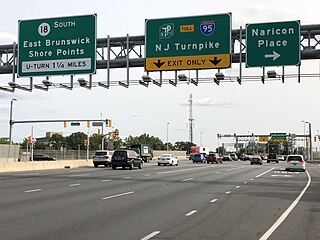
Route 18 is a 42.8-mile-long (68.9 km) state highway in the central part of the US state of New Jersey. It begins at an intersection with Route 138 in Wall Township, Monmouth County and ends at Interstate 287 (I-287) in Piscataway Township, Middlesex County. Route 18 is a major route through central New Jersey that connects the Jersey Shore to the Raritan Valley region, connecting the county seats of Monmouth (Freehold) and Middlesex respectively. The route runs through Ocean Township, Marlboro Township, East Brunswick, and is the main thoroughfare for Rutgers University. Much of the route is a freeway. The remainder of the route is an arterial road with traffic lights in the East Brunswick and Old Bridge areas, and a boulevard in the remainder of Piscataway. Route 18 was designated in 1939 as a proposed freeway from Old Bridge to Eatontown. The section west of Old Bridge was formerly designated as part Route S28, a prefixed spur of State Highway Route 28 from Middlesex to Matawan. The designation, assigned in the 1927 renumbering, remained until a second renumbering in 1953. At that point, Route S28 was redesignated as Route 18, though the section from Old Bridge to Matawan was signed as TEMP 18, as this section would be decommissioned when the Route 18 freeway was built.
East Brunswick is a township in Middlesex County, in the U.S. state of New Jersey. The suburban bedroom community is part of the New York City metropolitan area and is located on the southern shore of the Raritan River, directly adjacent to the city of New Brunswick and located roughly 29 miles (47 km) away from New York City. As of the 2020 United States census, the township's population was 49,715, its highest decennial count ever and an increase of 2,203 (+4.6%) from the 2010 census count of 47,512, which in turn reflected an increase of 756 (+1.6%) from the 46,756 counted in the 2000 census.

Milltown is a borough in Middlesex County, in the U.S. state of New Jersey. The borough is nestled within the heart of the Raritan Valley region, with Lawrence Brook flowing through the center of the community. As of the 2020 United States census, the borough's population was 7,037, an increase of 144 (+2.1%) from the 2010 census count of 6,893, which in turn reflected a decrease of 107 (−1.5%) from the 7,000 counted in the 2000 census.

The Raritan River is a major river of New Jersey. Its watershed drains much of the mountainous area of the central part of the state, emptying into the Raritan Bay on the Atlantic Ocean.

North Brunswick is a township in Middlesex County, in the U.S. state of New Jersey. It is centrally located in the Raritan Valley region within the New York metropolitan area. As of the 2020 United States census, the township's population was 43,905, an increase of 3,163 (+7.8%) from the 2010 census count of 40,742, which in turn reflected an increase of 3,455 (+12.3%) from the 36,287 counted in the 2000 census.

The Raritan River Rail Road was a 12-mile (19 km) shortline railroad in Middlesex County, New Jersey U.S., Founded in 1888, it was based in South Amboy, from which it ran west as far as New Brunswick. It served both passengers and freight in its heyday and operated profitably throughout much of its existence. The Raritan River was absorbed into Conrail in 1980, becoming a branch line of Conrail Shared Assets Operations. It terminates at U.S. Route 1 in North Brunswick.

The School of Environmental and Biological Sciences (SEBS) is a constituent school of Rutgers University's New Brunswick-Piscataway campus. Formerly known as Cook College—which was named for George Hammell Cook, a professor at Rutgers in the 19th Century—it was founded as the Rutgers Scientific School and later College of Agriculture after Rutgers was named New Jersey's land-grant college under the Morrill Act of 1862. Today, unlike the other arts and sciences schools at Rutgers, the School of Environmental and Biological Sciences specializes in environmental science, animal science and other life sciences. Although physically attached to the New Brunswick-Piscataway campus, most of the SEBS campus lies in North Brunswick, New Jersey.
Manalapan Brook is a tributary of the South River in Monmouth and Middlesex counties, New Jersey in the United States.

The Millstone River is a 38.6-mile-long (62.1 km) tributary of the Raritan River in central New Jersey in the United States.
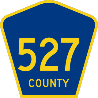
County Route 527 is a county highway in the U.S. state of New Jersey. The highway extends 84.86 mi (136.57 km) from Main Street in Toms River Township to Pompton Avenue in Cedar Grove. It passes through more counties (six) than any other county route in New Jersey. CR 527 is also the second longest 500-series county route in New Jersey after Route 519. The county route traverses through the northernmost stretches of the Pine Barrens in South Jersey, much of the Raritan Valley and Rahway Valley regions in Central Jersey, and the First and Second Watchung Mountains in North Jersey. It passes through Ocean, Monmouth, Middlesex, Somerset, Union, and Essex counties on the eastern side of the state.
Weston is an unincorporated community and census-designated place (CDP) located in Franklin Township, in Somerset County, in the U.S. state of New Jersey. As of the 2010 United States Census, the CDP's population was 1,235.
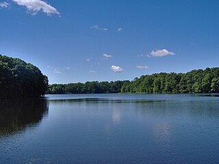
Farrington Lake is a scenic freshwater reservoir in Middlesex County, New Jersey near Milltown, New Jersey. Created by a dam on the Lawrence Brook, a tributary of the Raritan River, the lake is in fact a widened section of the Lawrence Brook. Its main tributaries are the Ireland Brook, the Beaverdam Brook, and the Oakeys Brook.

Oakeys Brook is a tributary of Lawrence Brook, a branch of the Raritan River in Middlesex County, New Jersey in the United States.

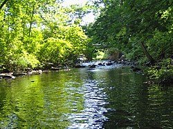
Sucker Brook is a tributary of Lawrence Brook in central New Jersey in the United States.

Sawmill Brook is a tributary of Lawrence Brook in northwestern East Brunswick, New Jersey in the United States.
Ireland Brook is a tributary of Lawrence Brook in Middlesex County, New Jersey in the United States.
Beaverdam Brook is a tributary of Lawrence Brook in central East Brunswick, New Jersey in the United States.

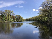
The Westons Mill Pond is a dammed section of the Lawrence Brook. The dam is located in the Westons Mills section of East Brunswick, New Jersey, United States, but the pond also borders the city of New Brunswick and North Brunswick Township. It is one of a series of dams on the Lawrence Brook. The Westons Mill Pond Dam is the dam that controls reservoir output. The Westons Mill Pond is available for boating, although gasoline motors are prohibited due to the highly sensitive wildlife ecosystems found there.
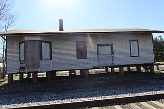
The Raritan River Freight Station is the only surviving station of the Raritan River Railroad and is located in Milltown, New Jersey. It is privately owned by James Curran who has agreed to sell the station to the Raritan River Railroad Historical Society for one dollar if they can find the means of moving it off of his property.