Round Valley Reservoir

Last updated

Round Valley Reservoir
RoundValleySign2.JPG
USA New Jersey relief location map.svg
Red pog.svg
Round Valley Reservoir
Usa edcp relief location map.png
Red pog.svg
Round Valley Reservoir
Location Clinton Township, New Jersey
Coordinates 40°36′50.0″N74°49′21.7″W / 40.613889°N 74.822694°W / 40.613889; -74.822694
Type Reservoir
Basin  countriesUnited States
Surface areaover 2,300 acres (9.3 km2)
Max. depth180 ft (55 m)
Water volume55,000,000,000 US gal (0.21 km3)
Surface elevation381 ft (116 m)

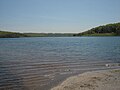
The Round Valley Reservoir in Clinton Township in Hunterdon County, New Jersey, United States, was formed in 1960 when the New Jersey Water Authority constructed two large dams and flooded a large valley. The reservoir is named after the naturally formed circular valley surrounded by Cushetunk Mountain. The deep valley was caused by erosion of the soft sedimentary rock. The surrounding ridges of Cushetunk Mountain endure because they were underlaid with dense and durable volcanic rock diabase that cooled slowly under the surface of the earth. The reservoir covers what used to be a farming community, with remains of a school and a church on the lake floor among other buildings. [1] [2]

Contents

Reaching depths of 180 feet (55 m), this 2,350 acres (9.5 km2) reservoir is best known for its pristine clear blue waters. The reservoir contains 55 billion US gallons (210,000,000 m3) of water for use in central New Jersey, making it the largest in the state. Its water is distributed during times of drought via the nearby south branch of the Raritan River. The New Jersey Division of Wildlife (a department of the New Jersey Department of Environmental Protection) claims the reservoir is the southernmost body of water that contains naturally reproducing lake trout. This is one of only two lakes in New Jersey with lake trout, the other being Merrill Creek Reservoir in Warren County. Some of the other species of fish in the lake include bass, pickerel, catfish, american eel, yellow perch, brown trout, and rainbow trout. The park also has a wilderness area for camping, swimming and SCUBA diving facilities, a boat ramp and nature hiking and biking trails. The reservoir has been called the Bermuda Triangle of New Jersey, and over 26 people have drowned there since 1971. Six of them have never been found. [3] [4]

Round Valley Reservoir, Clinton Township, NJ RoundValleySign.JPG
Round Valley Reservoir, Clinton Township, NJ

Related Research Articles

<span class="mw-page-title-main">Detroit Lake</span> Reservoir in Oregon, United States

Detroit Lake is a reservoir impounded by the Detroit Dam on the North Santiam River 46 miles (74 km) southeast of Salem, Oregon, United States. The lake is adjacent to Oregon Route 22 near the city of Detroit. This mesotrophic lake stores water for use by the city of Salem and other nearby communities.

<span class="mw-page-title-main">Curecanti National Recreation Area</span> National Park Service in Colorado, US

Curecanti National Recreation Area is a National Park Service unit located on the Gunnison River in western Colorado. Established in 1965, Curecanti National Recreation Area is responsible for developing and managing recreational facilities on three reservoirs, Blue Mesa Reservoir, Morrow Point Reservoir and Crystal Reservoir, constructed on the upper Gunnison River in the 1960s by the U.S. Bureau of Reclamation to better utilize the vital waters of the Colorado River and its major tributaries. A popular destination for boating and fishing, Curecanti offers visitors two marinas, traditional and group campgrounds, hiking trails, boat launches, and boat-in campsites. The state's premiere lake trout and Kokanee salmon fisheries, Curecanti is a popular destination for boating and fishing, and is also a popular area for ice-fishing in the winter months.

<span class="mw-page-title-main">Stevens Creek Reservoir</span> Reservoir in Santa Clara County, California

Stevens Creek Reservoir is an artificial lake located in the foothills of the Santa Cruz Mountains near Cupertino, California. A 1,063-acre (430 ha) county park surrounds the reservoir and provides limited fishing, picnicking, hiking, and horseback riding activities. Although swimming is not allowed, non-power boating is allowed for certain parts of the year. No powered boats or jet skis are allowed. All vessels must be inspected for invasive Quagga mussels prior to launch.

<span class="mw-page-title-main">Lake Success (California)</span> Lake in California

Lake Success is a lake near Porterville, California on the Tule River at 36.06°N 118.92°W. It is formed by Success Dam and has a capacity of 82,000 acre-feet (101,000,000 m3). The 156 feet (48 m) tall earth dam is owned and operated by the U.S. Army Corps of Engineers. Its construction was completed in 1961. The project's primary purpose is flood control, but the lake also provides water for irrigation and recreation. California State Route 190 also crosses the lake's only bridge.

<span class="mw-page-title-main">Wachusett Reservoir</span> Second largest body of water in the state of Massachusetts

The Wachusett Reservoir is the second largest body of water in the state of Massachusetts. It is located in central Massachusetts, northeast of Worcester. It is part of the water supply system for metropolitan Boston maintained by the Massachusetts Water Resources Authority (MWRA). It has an aggregate capacity of 65 billion US gallons (250,000,000 m3) and an area of almost 7 square miles (18 km2). Water from the reservoir flows to the covered Norumbega Storage Facility via the Cosgrove Tunnel and the MetroWest Water Supply Tunnel. The reservoir has a maximum depth of 120 feet (37 m) and a mean depth of 48 feet (15 m).

<span class="mw-page-title-main">Ramapo Mountain State Forest</span> Forest in New Jersey, United States

Ramapo Mountain State Forest is a 4,200-acre (17 km2) state forest in Bergen and Passaic Counties in New Jersey. The park is operated and maintained by the New Jersey Division of Parks and Forestry.

<span class="mw-page-title-main">Delaware Water Gap National Recreation Area</span> Protected area

Delaware Water Gap National Recreation Area is a 70,000-acre (28,000 ha) national recreation area administered by the National Park Service in northwest New Jersey and northeast Pennsylvania. It is centered around a 40-mile (64 km) stretch of the Delaware River designated the Middle Delaware National Scenic River. At the area's southern end lays the Delaware Water Gap, a dramatic mountain pass where the river cuts between Blue Mountain and Kittatinny Mountain.

<span class="mw-page-title-main">Lake Murray (California)</span> Reservoir in San Diego, California

Lake Murray is a reservoir in San Diego, California, operated by the City of San Diego's Public Utilities Department. Although thinly divided by a few housing communities and select roadways, it is technically considered to be part of the jurisdiction which makes up Mission Trails Regional Park. When full, the reservoir covers 171.1 acres (69.2 ha), has a maximum water depth of 95 feet (29 m), and a shoreline of 3.2 miles (5.1 km). The asphalt-paved service road lining roughly two-thirds of the lake's perimeter is a popular recreation site for the Navajo community as well as residents of the northernmost neighborhoods in La Mesa. It lies south of Cowles Mountain and a small golf course. It also functions as an important aeronautical reporting point for aircraft inbound to land at Montgomery-Gibbs Executive Airport.

<span class="mw-page-title-main">Foster Reservoir</span> Reservoir in Oregon, United States

Foster Reservoir is a reservoir created by Foster Dam on the South Santiam River in the city of Foster, Oregon, United States. The reservoir is approximately 5.6 km (3.5 mi) long and covers approximately 494 ha when full. Primary use of the reservoir is recreation in the summer and flood control in the winter and spring.

<span class="mw-page-title-main">Folsom Lake</span> Reservoir on the American River in the Sacramento metropolitan area

Folsom Lake is a reservoir on the American River in the Sierra Nevada foothills of California, United States.

<span class="mw-page-title-main">Whiskeytown–Shasta–Trinity National Recreation Area</span> National recreation area in California, United States

The Whiskeytown–Shasta–Trinity National Recreation Area is a United States National Recreation Area in northern California. The recreation area was authorized in 1965 by the United States Congress. Recreational activities available include swimming, fishing, boating, camping, and hiking.

<span class="mw-page-title-main">Kittatinny Valley State Park</span>

Kittatinny Valley State Park is located in Andover Township and extends into Andover Borough, New Jersey. Features include Glacial lakes, limestone outcroppings, former railroads, and a small airport. Lake Aeroflex and Gardner's Pond form part of the headwaters of the Pequest River and are excellent for fishing and boating. The park is home to a variety of wildlife such as whitetail deer, wild turkeys, a variety of songbirds, beavers, muskrats, and squirrels. The park is operated and maintained by the New Jersey Division of Parks and Forestry.

<span class="mw-page-title-main">Broken Bow Lake</span> Reservoir in McCurtain County, Oklahoma

Broken Bow Lake is a reservoir in southeastern Oklahoma, located on Mountain Fork River and 9 miles (14 km) northeast of the town of Broken Bow in McCurtain County. It is one of the largest fresh water lakes within the state of Oklahoma, and a popular tourist destination for locals and visitors from neighboring Texas and Arkansas.

<span class="mw-page-title-main">Saugatuck Reservoir</span> Reservoir in Connecticut, United States

The Saugatuck Reservoir is a reservoir in Fairfield County, Connecticut, United States, that straddles the border between the towns of Redding, Weston, and Easton. Its completion is marked by the creation of the Samuel P. Senior dam of the Saugatuck River in January 1942, and provides water to several of the nearby towns. The reservoir is surrounded by the Centennial Watershed State Forest and a small section of the Trout Brook Valley State Park Reserve on the southeast end of the reservoir. The Saugatuck Reservoir utilizes an uncontrolled spillway adjacent to the Samuel P. Senior dam that effectively limits the maximum water level. There is also a concrete levee positioned on the southeastern side of the reservoir that prevents water from flooding Trout Brook Valley.

<span class="mw-page-title-main">Loon Lake (California)</span> Reservoir in El Dorado County, California

Loon Lake is a reservoir in the Eldorado National Forest of El Dorado County, California, United States. The 76,200 acre⋅ft (94,000,000 m3) lake is formed by Loon Lake Dam, completed in 1963 as part of the Upper American River Project by Sacramento Municipal Utility District to conserve spring snow melt runoff for use during the summer and autumn for hydroelectric power production. Loon Lake Dam impounds water at the headwaters of Gerle Creek which, prior to the dam, flowed intermittently through (natural) Loon and Pleasant Lakes. But most of the water now stored in Loon Lake arrives from Buck Island Reservoir in the adjacent Rubicon River watershed by way of the Buck-Loon Tunnel. Nearby is Loon Lake Chalet, a popular winter recreation destination. In summer, a boat ramp for water sports and camping are available, but the area is less popular than nearby Union Valley Reservoir and Rubicon Trail.

<span class="mw-page-title-main">Stokes State Forest</span>

Stokes State Forest is a state park located in Sandyston, Montague and Frankford in Sussex County, New Jersey, United States. Stokes comprises 16,447 acres (66.56 km2) of mountainous woods in the Kittatinny Mountains, extending from the southern boundary of High Point State Park southwestward to the eastern boundary of the Delaware Water Gap National Recreation Area. The park is operated and maintained by the New Jersey Division of Parks and Forestry.

<span class="mw-page-title-main">Watauga Lake</span> Reservoir in Tennessee, United States

Watauga Lake, located east of Elizabethton, Tennessee, is the local name of the Watauga Reservoir created by the Tennessee Valley Authority (TVA) with the 1948 completion of the TVA Watauga Dam.

<span class="mw-page-title-main">Spruce Run Recreation Area</span>

Spruce Run Recreation Area is a 1,290-acre (5.2 km2) New Jersey state recreation area located in Union Township and Clinton Township in Hunterdon County, New Jersey, United States. It encompasses the Spruce Run Reservoir that is used as a backup reservoir to protect the state from prolonged droughts. The reservoir is the third largest in the state, after Round Valley and Wanaque Reservoir. The reservoir is used for recreation purposes, including hunting, fishing, boating and swimming.

<span class="mw-page-title-main">Cushetunk Mountain</span> Mountain in New Jersey, US

Cushetunk Mountain is a ring shaped mountain in the U.S. state of New Jersey, located in Readington and Clinton Township in Hunterdon County. The Lenape Native Americans called the mountain "Cushetunk" meaning "place of hogs" after the wild hogs found there. In the 1960s, the valley at the heart of the mountain was dammed and filled with water to create Round Valley Reservoir. Today, the mountain and its accompanying lake act as a vital water supply to Central New Jersey, while at the same time providing numerous recreational opportunities to the region.

<span class="mw-page-title-main">Little Dell Reservoir</span> Reservoir in the state of Utah, United States

Little Dell Reservoir is a reservoir in eastern Salt Lake County, Utah, United States, about 13 miles (21 km) east of Salt Lake City in the western Wasatch Mountains.

References

  1. "The Tragic Story Behind The Village That Was Flooded To Make Way For New Jersey's Round Valley Reservoir". September 21, 2019. Retrieved October 17, 2021.
  2. BlanchardFamilyPosts (September 5, 2015). "The Town at the bottom of Round Valley 090515". Archived from the original on December 21, 2021. Retrieved October 17, 2021 via YouTube.
  3. Police Search New Jersey's 'Bermuda Triangle': Top News Stories at Officer.com
  4. N.J.'s 'Bermuda Triangle': Mystery surrounds Clinton fishing hole's deep, dark past