
Stony Brook, also known as Stoney Brook, is a tributary of the Millstone River in Hunterdon and Mercer counties, New Jersey, in the United States.

Rocky Brook is a tributary of the Millstone River in Monmouth and Mercer counties, New Jersey in the United States.
Beden Brook, also Bedens Brook, Beden's Brook, or Beeden's Brook, is a tributary of the Millstone River in central New Jersey in the United States.

Stony Brook is a tributary of Green Brook in central New Jersey in the United States.

The Skylands Region is a region and marketing area of the State of New Jersey located in the Northern and Central part of the state. It is one of six tourism regions established by the New Jersey State Department of Tourism, the others being the Gateway Region, Greater Atlantic City Region, the Southern Shore Region, the Delaware River Region and the Shore Region. The area officially encompasses Hunterdon, Morris, Somerset, Sussex and Warren counties; the northwestern part of the Passaic County fits in with the Skylands Region, but it is part of the Gateway Region and not the Skylands Region. One could also say that the western most part of Bergen is also part of the skylands. The area features uplifted land, rolling hills and mountains characteristic of North Jersey. The region contains 60,000 acres of state parkland, and a diverse geography filled with lakes, rivers and picturesque hills.
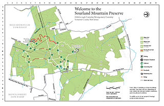
The Sourland Mountain Preserve is located on Sourland Mountain, in the Sourlands region of New Jersey. It is within Hillsborough Township and Montgomery Township of Somerset County.

Royce Brook is a tributary of the Millstone River in Hillsborough and Manville, New Jersey in the United States.

The Sourlands is a region in the US state of New Jersey that includes portions of Hunterdon County, Mercer County and Somerset County. It is centered on Sourland Mountain and comprises parts of Lambertville, East Amwell, West Amwell, Hillsborough, Hopewell Boro, Hopewell Township, Montgomery. The region is flanked by the Hopewell Fault to the south and Amwell Valley to the north that runs from Mount Airy to an area just west of Flagtown and a diabase formation running from Lambertville to Mount Airy. The Sourland also include a hilly area towards the southwest called Pleasant Valley, with a number of farms. Although much of the Sourlands is not conducive to farming, Pleasant Valley and the slopes on the surrounding ridges have a number of farms. The slopes of the ridge to the north are also home to Unionville Vineyard.

Rocky Hill Ridge, also known as the Mount Lucas-Rocky Hill Ridge, named after Lucas Voorhees, an 18th-century landowner, is a diabase trap rock ridge running west to east in the U.S. State of New Jersey. Diabase intrusions form Baldpate Mountain and Pennington Mountain, the Mount Rose extension of the Mount Lucas-Rocky Hill ridge, and part of the Sourland Mountains. The Ridge is nine miles long and continues across the Millstone River, just below The Georgetown Franklin Turnpike, as the Ten-Mile Run Mountain and Lawrence Brook Mountain. The western section of the ridge, which runs to the northwest to The Sourlands is the Mount Rose section of the ridge.

Peters Brook is a tributary of Stony Brook in Mercer and Hunterdon counties, New Jersey in the United States.

Sucker Brook is a tributary of Lawrence Brook in central New Jersey in the United States.

Sawmill Brook is a tributary of Lawrence Brook in northwestern East Brunswick, New Jersey in the United States.

Cranbury Brook, also known as Cranberry Brook, is a tributary of the Millstone River in Middlesex and Monmouth Counties, New Jersey in the United States.

Cruser Brook, also known as Crusers Brook, is a tributary of Pike Run in Somerset County, New Jersey in the United States.
Roaring Brook is a tributary of Cruser Brook in Somerset County, New Jersey, in the United States.
Back Brook is a tributary of Pike Run in Somerset County, New Jersey in the United States. It is located on the east side of Sourland Mountain.

Pike Run, also known as North Pike Run, is a tributary of Beden Brook in Somerset County, New Jersey in the United States. It is the namesake for the nearby residential development of Pike Run in Belle Mead, New Jersey.

Baldwins Creek is a tributary of the Stony Brook in Mercer County, New Jersey in the United States.

Stony Brook Branch is a tributary of the Stony Brook in Mercer County, New Jersey in the United States.


