
The New Jersey Turnpike (NJTP) is a system of controlled-access toll roads in the U.S. state of New Jersey. The turnpike is maintained by the New Jersey Turnpike Authority. The 117.2-mile (188.6 km) mainline's southern terminus is at the Delaware Memorial Bridge on I-295 in Pennsville. Its northern terminus is at an interchange with US 46 in Ridgefield Park. Construction of the mainline, from concept to completion, took a total of 22 months between 1950 and 1951. It was opened to traffic on November 5, 1951, between its southern terminus and exit 10.

Route 18 is a 47.92-mile-long (77.12 km) state highway in the central part of the US state of New Jersey. It begins at an intersection with Route 138 in Wall Township, Monmouth County, and ends at Interstate 287 (I-287) in Piscataway, Middlesex County. Route 18 is a major route through Central New Jersey that connects the Jersey Shore to the Raritan Valley region, connecting the seats of Monmouth County (Freehold) and Middlesex County respectively. The route runs through Ocean Township, Marlboro, East Brunswick, and is the main thoroughfare for Rutgers University. Much of the route is a freeway. The remainder of the route is an arterial road with traffic lights in the East Brunswick and Old Bridge areas, and a boulevard in the remainder of Piscataway. Route 18 was designated in 1939 as a proposed freeway from Old Bridge to Eatontown. The section west of Old Bridge was formerly designated as part Route S28, a prefixed spur of State Highway Route 28 from Middlesex to Matawan. The designation, assigned in the 1927 renumbering, remained until a second renumbering in 1953. At that point, Route S28 was redesignated as Route 18, though the section from Old Bridge to Matawan was signed as TEMP 18, as this section would be decommissioned when the Route 18 freeway was built.

The Pennsylvania Turnpike, sometimes shortened to Penna Turnpike or PA Turnpike, is a controlled-access toll road which is operated by the Pennsylvania Turnpike Commission (PTC) in Pennsylvania. It runs for 360 miles (580 km) across the southern part of the state, connecting Pittsburgh and Philadelphia, and passes through four tunnels as it crosses the Appalachian Mountains. A component of the Interstate Highway System, it is part of Interstate 76 (I-76) between the Ohio state line and Valley Forge. I-70 runs concurrently with I-76 between New Stanton and Breezewood, Interstate 276 (I-276) between Valley Forge and Bristol Township, and I-95 from Bristol Township to the New Jersey state line.

Middlesex County is a county located in the north-central part of the U.S. state of New Jersey, extending inland from the Raritan Valley region to the northern portion of the Jersey Shore. As of the 2020 United States census, the county was the state's third-most populous county with a population of 863,162, its highest decennial count ever and an increase of 53,304 (+6.6%) from the 2010 census count of 809,858, which in turn reflected an increase of 59,696 (8.0%) from the 750,162 counted in the 2000 census. Middlesex is part of the New York metropolitan area. Many communities within the county serve as commuter towns to and from New York City and other points north. The county is part of the Central Jersey region of the state.

Route 31 is a state highway in New Jersey, United States. It runs 48.93 miles (78.75 km) from US 206/US 1 Bus. in Trenton, Mercer County, north to an intersection with US 46 in the Buttzville section of White Township, Warren County. Along the way, Route 31 heads through the communities of Flemington, Clinton, and Washington. Most of the highway is state-maintained; however, the section within the city limits of Trenton is maintained by the city. Much of Route 31 is a two-lane highway that passes through farmland, woodland, and mountainous areas. Two portions of the route—from Trenton to Pennington and from Ringoes to Clinton—consist of more development.

The Raritan River is a river of the U.S. state of New Jersey. Its watershed drains much of the mountainous areas in the northern and central sections of the state, emptying into the Raritan Bay near Staten Island on the Atlantic Ocean.

The Garden State Parkway (GSP) is a controlled-access toll road that stretches the north–south length of eastern New Jersey from the state's southernmost tip near Cape May north to the New York state line at Montvale. Its name refers to New Jersey's nickname, the "Garden State". The parkway has an unsigned reference number of Route 444 by the New Jersey Department of Transportation (NJDOT). At its north end, the road becomes the Garden State Parkway Connector, a component of the New York State Thruway system that connects to the Thruway mainline in Ramapo, New York.

The Governor Alfred E. Driscoll Bridge, is a bridge on the Garden State Parkway in the U.S. state of New Jersey, spanning the Raritan River near its mouth in Raritan Bay. The bridge connects the Middlesex County communities of Woodbridge Township on the north with Sayreville on the south. With a total of 15 travel lanes and 6 shoulder lanes, it is one of the world's widest and busiest motor vehicle bridges. Only 30 feet east of the Driscoll Bridge is the Edison Bridge, which carries U.S. Route 9. The bridge offers views of some of the taller buildings in the Lower Manhattan skyline, the New Brunswick skyline, the Verrazzano-Narrows Bridge, and the Outerbridge Crossing.

The Delaware Memorial Bridge is a dual-span suspension bridge crossing the Delaware River. The toll bridges carry Interstate 295 and U.S. Route 40 and is also the link between Delaware and New Jersey. The bridge was designed by the firm of Howard, Needles, Tammen & Bergendoff with consulting help from engineer Othmar Ammann, whose other designs include the George Washington Bridge and the Verrazzano-Narrows Bridge.
Central Jersey, or Central New Jersey, is the middle region of the U.S. state of New Jersey. The designation Central Jersey is a distinct administrative toponym. While New Jersey is often divided into North Jersey and South Jersey, many residents recognize Central Jersey as a distinct third entity. As of the 2020 census, Central Jersey has a population of 3,580,999.
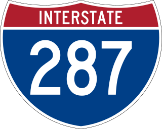
Interstate 287 (I-287) is an auxiliary Interstate Highway in the US states of New Jersey and New York. It is a partial beltway around New York City, serving northern New Jersey and the counties of Rockland and Westchester in New York. I-287, which is signed north–south in New Jersey and east–west in New York, follows a roughly horseshoe-shaped route from the New Jersey Turnpike (I-95) in Edison, New Jersey, clockwise to the New England Thruway (I-95) in Rye, New York, for 98.72 miles (158.87 km). Through New Jersey, I-287 runs west from its southern terminus in Edison through suburban areas. In Bridgewater Township, the freeway takes a more northeasterly course, paralleled by US Route 202 (US 202). The northernmost part of I-287 in New Jersey passes through mountainous surroundings. Upon entering New York at Suffern, I-287 turns east on the New York State Thruway (I-87) and runs through Rockland County. After crossing the Hudson River on the Tappan Zee Bridge, I-287 splits from I-87 near Tarrytown and continues east through Westchester County on the Cross Westchester Expressway until it reaches the New England Thruway. Within New Jersey, I-287 is maintained by the New Jersey Department of Transportation (NJDOT), and, within New York, it is maintained by the New York State Thruway Authority (NYSTA).
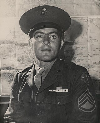
John Basilone was a United States Marine Corps gunnery sergeant who received the Medal of Honor for actions during the Battle for Henderson Field in the Guadalcanal campaign, and the Navy Cross posthumously for extraordinary heroism during the Battle of Iwo Jima. He was the only enlisted Marine to receive both of these decorations in World War II.

The Edison Bridge and the Vieser bridge are a pair of bridges that carry U.S. Route 9 in the state of New Jersey, spanning the Raritan River near its mouth in Raritan Bay. The bridge, which connects Woodbridge on the north with Sayreville on the south, was opened to weekend traffic starting on October 11, 1940, and was opened permanently on November 15, 1940. As of 2003, the bridge carries more than 82,000 vehicles daily and is owned and operated by the New Jersey Department of Transportation. It also runs directly parallel to the Driscoll Bridge, which carries the Garden State Parkway.

The Pennsylvania Turnpike/Interstate 95 Interchange Project is an ongoing road construction project to build an interchange between Interstate 95 (I-95) and the Pennsylvania Turnpike in Bristol Township, Bucks County, Pennsylvania, in the United States. The $553 million first stage is complete: a pair of flyover ramps–one connecting I-95 northbound with the eastbound turnpike and the other connecting the westbound turnpike with I-95 southbound—that opened in 2018, with some cleanups to connecting roads completed in 2021. Construction of the remaining ramps is expected to begin when funding is available.

U.S. Route 9 (US 9) is a United States Numbered Highway in the Mid-Atlantic region of the United States, running from Laurel, Delaware, to Champlain, New York. In New Jersey, the route runs 166.80 miles (268.44 km) from the Cape May–Lewes Ferry terminal in North Cape May, Cape May County, where the ferry carries US 9 across the Delaware Bay to Lewes, Delaware, north to the George Washington Bridge in Fort Lee, Bergen County, where the route along with Interstate 95 (I-95) and US 1 continue into New York City. US 9 is the longest U.S. Highway in the state.

The Donald and Morris Goodkind Bridges are a pair of bridges on U.S. Route 1 in the U.S. state of New Jersey. The bridges cross the Raritan River, connecting Edison on the north bank with New Brunswick on the south.

U.S. Route 1 (US 1) is a U.S. Route which parallels the East Coast of the United States, running from Key West, Florida, in the south to Fort Kent, Maine, at the Canadian border in the north. Of the entire length of the route, 66.06 miles (106.31 km) of it runs through New Jersey. It enters the state from Pennsylvania on the Trenton–Morrisville Toll Bridge over the Delaware River in the state capital of Trenton, running through the city on the Trenton Freeway. From here, US 1 continues northeast as a surface divided highway through suburban areas, heading into Middlesex County and passing through New Brunswick and Edison. US 1 merges with US 9 in Woodbridge, and the two routes continue through northern New Jersey as US 1/9 to the George Washington Bridge over the Hudson River in Fort Lee. At this point, the road continues into New York City along with Interstate 95.
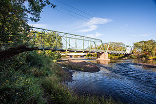
The Nevius Street Bridge is a double intersection Pratt truss bridge that once carried car traffic across the Raritan River between Hillsborough Township and Raritan Borough in Somerset County, New Jersey, United States. The bridge, described using its historic name, Raritan Bridge, was added to the National Register of Historic Places on November 12, 1992, for its engineering and method of construction. It is part of the Metal Truss Bridges in Somerset County Multiple Property Submission (MPS).
List of mayors of Raritan Township and Edison Township, New Jersey, United States. The township was renamed from Raritan to Edison in November 1954.
Morris Goodkind was chief bridge engineer for the New Jersey State Highway Department from 1925 to 1955, and was responsible for the construction of numerous bridges during that period. Goodkind emphasized the integration of architecture and aesthetics in bridge design and received awards from the American Society of Civil Engineers and the American Institute of Steel Construction for his designs.


