Oakeys Brook (New Jersey)

Last updated
Oakeys Brook
Oakeys Brook by School - 1.JPG
Oakeys Brook near Brunswick Acres School in North Brunswick
Oakeys Brook.JPG
Oakeys Brook map
Location
Country United States
Physical characteristics
Source 
  coordinates 40°25′56″N74°32′39″W / 40.43222°N 74.54417°W / 40.43222; -74.54417
Mouth  
  coordinates
40°25′06″N74°29′29″W / 40.41833°N 74.49139°W / 40.41833; -74.49139
  elevation
52 ft (16 m)
Basin features
Progression Lawrence Brook, Raritan River, Atlantic Ocean
River system Raritan River system
Tributaries 
  left Cow Yard Brook

Oakeys Brook is a tributary of Lawrence Brook, a branch of the Raritan River in Middlesex County, New Jersey in the United States.

Contents

Course

The source of Oakeys Brook is near Beekman Road in central South Brunswick. Farther downstream, it runs through the Nassau Square housing development on Augustine Drive. Then it crosses Henderson Road in northern South Brunswick (which is its official source at 40°25′56″N74°32′39″W / 40.43222°N 74.54417°W / 40.43222; -74.54417 [1] ), and runs beside the Brunswick Acres School in northern South Brunswick. It then crosses Route 1 and merges with another unnamed tributary. It continues flowing away from Black Horse Lane before coming toward it and crossing the railroad tracks a little farther north than the road reaches them. Another unnamed tributary joins it, along with Cow Yard Brook. It turns east, crosses Route 130 near Black Horse Lane, and crosses Davidson Mill Road before emptying into Farrington Lake, near Davidson Mill Road 40°25′06″N74°29′29″W / 40.41833°N 74.49139°W / 40.41833; -74.49139 . [1]

Animal life

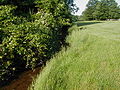
Oakeys Brook is an ecosystem full of many varieties of life, despite its proximity to human habitation in many upstream areas. Many tadpoles and frogs live in the stream, especially upstream where natural dams sometimes create small ponds. Snakes and occasionally turtles may be found by the stream. Upstream, numerous species of small fish live in it, providing food for some birds which live there. The deer cross on planks of wood to get food. It is easy for people to cross, but crayfish can snap at your feet

Accessibility

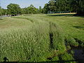
Oakeys Brook flows in many areas through developed sectors, where it is easily accessible. Students at Brunswick Acres are sometimes allowed to pick up the trash littered on the bank.

Terrain

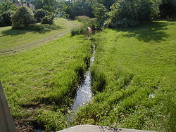
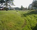
Oakeys Brook generally has a clay streambed. Upstream decay products turn the mud black, making it an ideal place for amphibians and turtles to hide in. Downstream, there are a few more rocks, although the stream is still muddy and deep. The stream flows through wetland areas in several places near Black Horse Lane.

This stream is generally low-lying, collecting water from various storm drainage systems. It is fed by swamp drainage and springs in the downstream areas but by storm drainage and farm drainage in upstream areas. Since a major source is storm drainage, it swells considerably during rains.

Tributaries

Sister tributaries

See also

Related Research Articles

<span class="mw-page-title-main">Lawrence Brook</span> River in the United States

Lawrence Brook is a tributary of the Raritan River in Middlesex County, New Jersey, in the United States.

<span class="mw-page-title-main">Loantaka Brook</span>

Loantaka Brook is a tributary of the Passaic River in New Jersey in the United States.

<span class="mw-page-title-main">Six Mile Run (New Jersey)</span> River in the United States

Six Mile Run is a tributary of the Millstone River that drains a large area in central Franklin Township in Somerset County and as well western portions of North Brunswick and South Brunswick Townships in Middlesex County, New Jersey in the United States.

<span class="mw-page-title-main">Nine Mile Run (New Jersey)</span> River in the United States

Nine Mile Run, known as Ninemile Run according to the USGS GNIS, is a moderately large tributary of the Six Mile Run, one of the branches of the Millstone River, in central New Jersey in the United States.

<span class="mw-page-title-main">Sucker Brook (Lawrence Brook tributary)</span> River in the United States

Sucker Brook is a tributary of Lawrence Brook in central New Jersey in the United States.

<span class="mw-page-title-main">Middlebush Brook (New Jersey)</span> River in the United States

Middlebush Brook is a tributary of Six Mile Run in Somerset County, New Jersey in the United States.

<span class="mw-page-title-main">Sawmill Brook (New Jersey)</span> River in the United States

Sawmill Brook is a tributary of Lawrence Brook in northwestern East Brunswick, New Jersey in the United States.

Ireland Brook is a tributary of Lawrence Brook in Middlesex County, New Jersey in the United States.

<span class="mw-page-title-main">Cross Brook (New Jersey)</span> River in the United States

Cross Brook is a tributary of Six Mile Run in Somerset and Middlesex Counties, New Jersey in the United States.

<span class="mw-page-title-main">Ten Mile Run (New Jersey)</span> River in the United States

Ten Mile Run is a tributary of the Millstone River, draining an area in southern South Brunswick and southern Franklin Park, New Jersey in the United States.

Beaverdam Brook is a tributary of Lawrence Brook in central East Brunswick, New Jersey in the United States.

<span class="mw-page-title-main">Cow Yard Brook (New Jersey)</span> River in the United States

The Cow Yard Brook is a small tributary of the Oakeys Brook, in central South Brunswick, New Jersey in the United States.

<span class="mw-page-title-main">Simonson Brook (New Jersey)</span> River in the United States

Simonson Brook, also known as Sunonson Brook, is a tributary of the Millstone River in southern Franklin Park, Somerset County, New Jersey in the United States.

<span class="mw-page-title-main">Terhune Run</span> River in the United States

Terhune Run is a tributary of Lawrence Brook in eastern South Brunswick, New Jersey in the United States.

<span class="mw-page-title-main">Little Catawissa Creek</span> Tributary of Catawissa Creek, Pennsylvania

Little Catawissa Creek is a tributary of Catawissa Creek in Columbia County and Schuylkill County, in Pennsylvania, in the United States. It is approximately 10.8 miles (17.4 km) long and flows through Conyngham Township in Columbia County and Union Township and North Union Township in Schuylkill County. The named tributaries of the creek include Stony Run and Trexler Run. The creek has some alkalinity and is slightly acidic. The main rock formations in the watershed of it are the Mauch Chunk Formation, the Pocono Formation, and the Pottsville Formation. A number of other rock formations occur in small areas of the watershed as well. The main soils in the watershed are the Leck Kill soil and the Hazleton soil.

<span class="mw-page-title-main">Messers Run</span> Tributary river in eastern Pennsylvania

Messers Run is a tributary of Catawissa Creek in Schuylkill County, Pennsylvania, in the United States. It is approximately 5.2 miles (8.4 km) long and flows through Kline Township and East Union Township. The only named tributary of the stream is Negro Hollow, but it has two unnamed tributaries. The creek has some alkalinity, but is slightly acidic. The main rock formations in the watershed of it are the Mauch Chunk Formation and the Pottsville Formation. The main soils in the watershed are the Leck Kill soil and the Hazleton soil.

Long Run is a tributary of Nescopeck Creek in Luzerne County, Pennsylvania, in the United States. It is approximately 3.0 miles (4.8 km) long and flows through Butler Township. The watershed of the stream has an area of 4.62 square miles (12.0 km2). Land uses in the watershed include forested land, agricultural land, and barren land. The waters of the stream are slightly acidic, but this is not caused by acid mine drainage. It is considered to be Class A Wild Trout Waters, a Coldwater Fishery, and a Migratory Fishery. The stream has two unnamed tributaries and at least one bridge crosses it.

<span class="mw-page-title-main">Pond Creek (Little Wapwallopen Creek tributary)</span> River

Pond Creek is a tributary of Little Wapwallopen Creek in Luzerne County, Pennsylvania, in the United States. It is approximately 6.4 miles (10.3 km) long and flows through Slocum Township and Conyngham Township. The watershed of the creek has an area of 9.69 square miles (25.1 km2) and is part of the Lower North Branch Susquehanna drainage basin. A bridge was built over the creek in 1956. In the early 1900s, the Glen Brook Water Company planned to construct a dam on the creek. The surficial geology in the vicinity of Pond Creek includes Wisconsinan Till, alluvium, boulder alluvium, alluvial fan, and bedrock consisting of sandstone and shale, as well as some patches of wetland.

<span class="mw-page-title-main">Cider Run (Bowman Creek tributary)</span> River in Pennsylvania, U.S.

Cider Run is a tributary of Bowman Creek in Wyoming County, Pennsylvania, in the United States. It is approximately 2.5 miles (4.0 km) long and flows through Forkston Township and Noxen Township. The watershed of the stream has an area of 3.77 square miles (9.8 km2). The stream is not designated as an impaired waterbody. Its watershed is classified as Exceptional Value waters and a Migratory Fishery and the stream is designated as a Wilderness Trout Stream.

Nine Partners Creek is a tributary of Tunkhannock Creek in Susquehanna County, Pennsylvania, in the United States. It is approximately 10 miles (16 km) long and flows through New Milford Township, Harford Township, and Lenox Township. The watershed of the creek has an area of 38.6 square miles (100 km2). The creek has two named tributaries: Butler Creek and Leslie Creek. The surficial geology in the vicinity of Nine Partners Creek includes Wisconsinan Till, alluvium, bedrock, alluvial fan, and wetlands. The creek's drainage basin is designated as a Coldwater Fishery and a Migratory Fishery.

References

  1. 1 2 "GNIS Detail - Oakeys Brook". USGS. Retrieved June 8, 2010.