| Shallow Brook | |
|---|---|
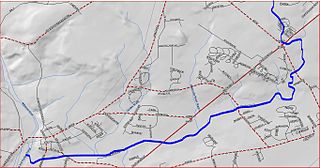
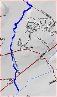
Shallow Brook map | |
| Country | United States |
| Physical characteristics | |
| Main source | 40°20′47″N74°29′4″W / 40.34639°N 74.48444°W |
| River mouth | 79 ft (24 m) 40°20′50″N74°34′59″W / 40.34722°N 74.58306°W Coordinates: 40°20′50″N74°34′59″W / 40.34722°N 74.58306°W |
| Basin features | |
| Progression | Devils Brook, Millstone River, Raritan River, Atlantic Ocean |
Shallow Brook is a tributary of Devils Brook in central New Jersey in the United States.

A tributary or affluent is a stream or river that flows into a larger stream or main stem river or a lake. A tributary does not flow directly into a sea or ocean. Tributaries and the main stem river drain the surrounding drainage basin of its surface water and groundwater, leading the water out into an ocean.

Devils Brook is a tributary of the Millstone River in central New Jersey in the United States.

New Jersey is a state in the Mid-Atlantic region of the Northeastern United States. It is a peninsula, bordered on the north and east by the state of New York, particularly along the extent of the length of New York City on its western edge; on the east, southeast, and south by the Atlantic Ocean; on the west by the Delaware River and Pennsylvania; and on the southwest by the Delaware Bay and Delaware. New Jersey is the fourth-smallest state by area but the 11th-most populous, with 9 million residents as of 2017, and the most densely populated of the 50 U.S. states; its biggest city is Newark. New Jersey lies completely within the combined statistical areas of New York City and Philadelphia and was the second-wealthiest U.S. state by median household income as of 2017.
Contents
Shallow Brook flows generally parallel to the Devils Brook, draining a similar area in Middlesex and Mercer counties.

Middlesex County is a county located in central New Jersey, United States. As of the 2017 Census estimate, the county's population was 842,798, making it the state's second-most populous county, an increase of 4.1% from the 2010 United States Census, when its population was enumerated at 809,858, making it the second-most populous county in the state. Middlesex is part of the New York metropolitan area, and its county seat is New Brunswick. The center of population of the state of New Jersey is located in Middlesex County, in East Brunswick Township, just east of the New Jersey Turnpike. The 2000 Census showed that the county ranked 63rd in the United States among the highest-income counties by median household. The Bureau of Economic Analysis ranked the county as having the 143rd-highest per capita income of all 3,113 counties in the United States as of 2009. Middlesex County holds the nickname, "The Greatest County in the Land".

Mercer County is a county located in the U.S. state of New Jersey. Its county seat is Trenton, the state capital. The county constitutes the Trenton-Ewing, NJ Metropolitan Statistical Area and is considered part of the New York Metropolitan Area by the United States Census Bureau, but also directly borders the Philadelphia metropolitan area and is included within the Federal Communications Commission's Philadelphia Designated Market Area and the greater Philadelphia-Reading-Camden Combined Statistical Area. As of the 2017 Census estimate, the county's population was 374,733, making it the state's 12th-most populous county, an increase of 2.2% from the 2010 United States Census, when its population was enumerated at 366,513, in turn an increase of 15,752 (4.5%) from the 350,761 enumerated in the 2000 Census, retaining its position as the 12th-most populous county in the state.