New Vernon is an unincorporated community and census-designated place located within Harding Township in Morris County, in the U.S. state of New Jersey. The community falls within the boundaries of Harding Township along with a portion of Green Village. New Vernon is the location of the governmental offices for Harding Township.

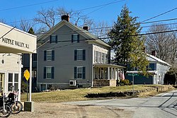
Pottersville is an unincorporated community and census-designated place (CDP) split between Bedminster Township in Somerset County and Tewksbury Township in Hunterdon County, in the U.S. state of New Jersey. The area is served as United States Postal Service ZIP Code 07979. As of the 2010 United States Census, the population for ZIP Code Tabulation Area 07979 was 589. In 1990, most of the village was listed on the National Register of Historic Places as the Pottersville Village Historic District.

Vincentown is an unincorporated community and census-designated place (CDP) located on the South Branch Rancocas Creek in Southampton Township of Burlington County, New Jersey. The area is served as United States Postal Service ZIP Code 08088.

Finesville is an unincorporated community and census-designated place (CDP) located within Pohatcong Township in Warren County, in the U.S. state of New Jersey. The CDP was defined as part of the 2010 United States Census. As of the 2010 Census, the CDP's population was 175.

Little York is an unincorporated community located along the border of Alexandria and Holland townships in Hunterdon County, in the U.S. state of New Jersey. Little York is located on County Route 614 3.1 miles (5.0 km) north-northeast of Milford. Little York has a post office with ZIP Code 08834.

Readingsburg, also known as Stone Mill, is an unincorporated community located along the South Branch Raritan River within Clinton Township in Hunterdon County, New Jersey.

Headquarters is an unincorporated community located within the Amwell Valley of Delaware Township in Hunterdon County, New Jersey. The settlement is centered around the intersection of Zentek Road and County Route 604. It is about 3 miles (4.8 km) from Ringoes to the east and 1 mile (1.6 km) from Sergeantsville to the west. The Headquarters Historic District was listed on the state and national registers of historic places in 2011 and had its boundary increased in 2016.

Millbrook, also known as Millbrook Village, is an unincorporated community located along Old Mine Road within Hardwick Township, formerly Pahaquarry Township, in Warren County, in the U.S. state of New Jersey. It is named after the Mill Brook, now known as Van Campens Mill Brook, a tributary of the Delaware River. The area is now part of the Delaware Water Gap National Recreation Area.

Washington Valley is an unincorporated community in the Whippany River valley within Morris Township in Morris County, in the U.S. state of New Jersey.

The John Smith House is a historic building located at 124 Washington Valley Road in the Washington Valley section of Morris Township in Morris County, New Jersey, United States. It was documented by the Historic American Buildings Survey (HABS) in 1937. The house was added to the National Register of Historic Places on January 1, 1976, for its significance in agriculture and architecture. It was designated a contributing property of the Washington Valley Historic District on November 12, 1992.

The Asbury Historic District is a 288-acre (117 ha) historic district encompassing the community of Asbury in Franklin Township of Warren County, New Jersey. It is bounded by County Route 632, County Route 643, Maple Avenue, Kitchen Road, and School Street and extends along the Musconetcong River into Bethlehem Township of Hunterdon County. It was listed on the National Register of Historic Places on March 19, 1993 for its significance in architecture, industry, religion, community development, politics/government, and commerce. The district includes 141 contributing buildings, a contributing structure, two contributing sites, and four contributing objects.

The Old Mine Road Historic District is a 687-acre (278 ha) historic district located along Old Mine Road in Sussex County and Warren County, New Jersey. It is part of the Delaware Water Gap National Recreation Area. The district was added to the National Register of Historic Places on December 3, 1980, for its significance in agriculture, archaeology, architecture, commerce, exploration/settlement, and transportation. It includes 24 contributing buildings and five contributing sites.

The Imlaydale Historic District is a 32-acre (13 ha) historic district primarily in Washington Township of Warren County, New Jersey. It was added to the National Register of Historic Places on March 27, 1991 for its significance in architecture, community development, industry, politics/government, and transportation. The listing includes 12 contributing buildings, four contributing structures, and two contributing sites.

The German Valley Historic District is a 69-acre (28 ha) historic district located in the Long Valley section of Washington Township in Morris County, New Jersey. The district was added to the National Register of Historic Places on July 14, 1983, for its significance in agriculture, education, transportation, industry, and religion.

Pleasant Valley is an unincorporated community located in Washington Township, Warren County, New Jersey, west of Washington, along the Pohatcong Creek. The hamlet was built around a mill on the creek during the mid-18th century. The Pleasant Valley Historic District, encompassing the village, is listed on the state and national registers of historic places.

The Anthony–Corwin Farm is a historic farmhouse located at 244 West Mill Road near Long Valley in Washington Township, Morris County, New Jersey. It was added to the National Register of Historic Places on May 1, 1992, for its significance in architecture. The 11.5-acre (4.7 ha) farm overlooks the valley formed by the South Branch Raritan River. The farmhouse is part of the Stone Houses and Outbuildings in Washington Township Multiple Property Submission (MPS).

The Leonard Neighbor Farmstead is a historic house located at 177 West Mill Road near Long Valley in Washington Township, Morris County, New Jersey. It was added to the National Register of Historic Places on May 1, 1992, for its significance in architecture. The farm overlooks the valley formed by the South Branch Raritan River. The house is part of the Stone Houses and Outbuildings in Washington Township Multiple Property Submission (MPS).

Franklin Corners is an unincorporated community located along the Passaic River at the intersection of County Route 613 and U.S. Route 202 in Bernards Township of Somerset County, New Jersey. In the 19th century, it had a grist mill, saw mill, general store, school, and several houses. The Franklin Corners Historic District, featuring Van Dorn's Mill, was listed on the National Register of Historic Places in 1975.

Millville is an unincorporated community located along River Road and Shimers Brook in Montague Township of Sussex County, New Jersey. The Montague Grange and other parts of the community are in the Delaware Water Gap National Recreation Area.

The Simon Van Duyne House is a historic house located at 58 Maple Avenue in the Pine Brook section of the township of Montville in Morris County, New Jersey. The oldest section was built c. 1750. It was documented by the Historic American Buildings Survey in 1936. The house was later added to the National Register of Historic Places on January 17, 1992, for its significance in architecture. The house was also listed as part of the Dutch Stone Houses in Montville, New Jersey Multiple Property Submission (MPS).