Kenvil, New Jersey | |
|---|---|
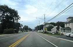 U.S. Route 46 traveling through Kenvil | |
 Location in Morris County and the state of New Jersey. | |
| Coordinates: 40°52′13″N74°37′54″W / 40.870198°N 74.631639°W | |
| Country | |
| State | |
| County | Morris |
| Township | Roxbury |
| Area | |
• Total | 1.36 sq mi (3.51 km2) |
| • Land | 1.19 sq mi (3.07 km2) |
| • Water | 0.17 sq mi (0.43 km2) 15.89% |
| Elevation | 709 ft (216 m) |
| Population | |
• Total | 1,806 |
| • Density | 1,522.7/sq mi (587.92/km2) |
| Time zone | UTC−05:00 (Eastern (EST)) |
| • Summer (DST) | UTC−04:00 (Eastern (EDT)) |
| ZIP Code | 07847 |
| FIPS code | 34-36720 [4] [5] [6] |
| GNIS feature ID | 02584005 [4] [7] |


Kenvil is an unincorporated community and census-designated place (CDP) [8] located within Roxbury Township, in Morris County, in the U.S. state of New Jersey. [9] As of the 2020 census, it had a population of 1,806. [3]
