Succasunna, New Jersey

Last updated

Succasunna, New Jersey
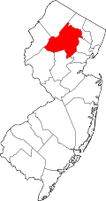
Morris County New Jersey incorporated and unincorporated areas Succusunna highlighted.svg
Location in Morris County and the state of New Jersey.
Location map of Morris County, New Jersey.svg
Red pog.svg
Succasunna
Location in Morris County
USA New Jersey relief location map.svg
Red pog.svg
Succasunna
Location in New Jersey
Usa edcp relief location map.png
Red pog.svg
Succasunna
Location in the United States
Coordinates: 40°51′04″N74°39′30″W / 40.851023°N 74.658201°W / 40.851023; -74.658201
Country Flag of the United States.svg  United States
State Flag of New Jersey.svg  New Jersey
County Morris
Township Roxbury
Area
[1]
  Total6.04 sq mi (15.64 km2)
  Land5.87 sq mi (15.20 km2)
  Water0.17 sq mi (0.43 km2)  1.14%
Elevation
[2]
751 ft (229 m)
Population
 (2020) [3]
  Total10,338
  Density1,761.46/sq mi (680.05/km2)
Time zone UTC−05:00 (Eastern (EST))
  Summer (DST) UTC−04:00 (Eastern (EDT))
ZIP Code
07876
FIPS code 34-71370 [4] [5] [6]
GNIS feature ID02584032 [4] [7]

Succasunna is an unincorporated community and census-designated place (CDP) in Roxbury Township, Morris County, New Jersey, United States, [8] serving as the township's downtown and population center. As of the 2020 census, it had a population of 10,338, [3] up from 9,152 in 2010. [9]

Contents

History

The name "Succasunna" comes from the Lenni Lenape Native American word for "land of black stones", most likely due to the rich iron ore deposits in the area. [10] The community was established circa 1740.

The Morris Canal was an important transportation link in the iron industry around Succasunna, carrying coal to iron-ore producing areas all over northern New Jersey. The canal was abandoned in 1924 and largely dismantled.

Succasunna was the site of the world's first electronic switching public telephone exchange. The Western Electric model 1ESS system was cut over for service on the New Jersey Bell 584 central office on May 30, 1965. A commemorative plaque on the wall of the central office building notes this historic event. [11] Instead of electro-mechanical relays, the 1ESS was the first commercial computerized electronic switching system. This innovation allowed for features of modern telephone service, like call forwarding, call waiting, and three-way calling. [12]

Geography

Succasunna is in western Morris County and occupies the southern portion of Roxbury Township. It is bordered to the northwest by Ledgewood and to the northeast by Kenvil, both in Roxbury Township. It is bordered to the southeast by Randolph Township, to the south by Chester Township, and to the southwest by Flanders in Mount Olive Township.

New Jersey Route 10 passes through the northeast part of Succasunna, leading northwest 1 mile (1.6 km) to its terminus at U.S. Route 46 in Ledgewood and east 13 miles (21 km) to Whippany. The Morristown and Erie Railway runs rail freight service through the area two to five times per week on its High Bridge Branch.

According to the U.S. Census Bureau, the Succasunna CDP has a total area of 6.04 square miles (15.64 km2), of which 5.87 square miles (15.20 km2) are land and 0.17 square miles (0.44 km2), or 2.78%, are water. [1] The community is drained by the Lamington River, which forms the southeast border of the CDP and is a tributary of the North Branch of the Raritan River, and by Drakes Brook, which flows southwest out of the community and is a tributary of the South Branch of the Raritan.

Demographics

Historical population
CensusPop.Note
2010 9,152
2020 10,33813.0%
Population sources: 2010 [9] [3]

Succasunna was part of the Succasunna-Kenvil CDP in the 2000 United States Census, which counted the combined population of Succasunna and Kenvil as 12,569. [13] For the 2010 census, the area was split into two CDPs, Succasunna, with a population of 9,152, [9] and Kenvil with 3,009 people. [14] [15] [16] [17]

2010 census

The 2010 United States census counted 9,152 people, 3,110 households, and 2,650 families in the CDP. The population density was 1,784.6 per square mile (689.0/km2). There were 3,163 housing units at an average density of 616.8 per square mile (238.1/km2). The racial makeup was 91.40% (8,365) White, 1.48% (135) Black or African American, 0.04% (4) Native American, 4.91% (449) Asian, 0.00% (0) Pacific Islander, 0.79% (72) from other races, and 1.39% (127) from two or more races. Hispanic or Latino of any race were 5.86% (536) of the population. [9]

Of the 3,110 households, 38.1% had children under the age of 18; 75.2% were married couples living together; 7.3% had a female householder with no husband present and 14.8% were non-families. Of all households, 12.2% were made up of individuals and 5.0% had someone living alone who was 65 years of age or older. The average household size was 2.94 and the average family size was 3.20. [9]

24.9% of the population were under the age of 18, 7.1% from 18 to 24, 20.7% from 25 to 44, 35.3% from 45 to 64, and 12.1% who were 65 years of age or older. The median age was 43.5 years. For every 100 females, the population had 98.2 males. For every 100 females ages 18 and older there were 93.5 males. [9]

Education

As part of Roxbury Township, residents of Succasunna are served by the Roxbury School District.

Established in 1963, St. Therese School is a Catholic school located in the community, operated under the auspices of the Roman Catholic Diocese of Paterson. [18] [19]

Notable people

People who were born in, residents of, or otherwise closely associated with Succasunna include:

Related Research Articles

<span class="mw-page-title-main">Old Bridge (CDP), New Jersey</span> Populated place in Middlesex County, New Jersey, US

Old Bridge is a census-designated place (CDP) in Old Bridge Township, Middlesex County, New Jersey, United States. As of the 2020 census, the CDP's population was 27,210, up from 23,753 in 2010. The Old Bridge CDP occupies only a portion of Old Bridge Township.

<span class="mw-page-title-main">Chester Township, New Jersey</span> Township in Morris County, New Jersey, US

Chester Township is a township in southwestern Morris County, in the U.S. state of New Jersey. As of the 2020 United States census, the township's population was 7,713, a decrease of 125 (−1.6%) from the 2010 census count of 7,838, which in turn reflected an increase of 556 (+7.6%) from the 7,282 counted in the 2000 census. The township's name is derived from Chestershire in England.

<span class="mw-page-title-main">Lake Telemark, New Jersey</span> Populated place in Morris County, New Jersey, US

Lake Telemark is an unincorporated community and census-designated place (CDP) in Rockaway Township, Morris County, New Jersey, United States. As of the 2020 census, the CDP's population was 1,172.

<span class="mw-page-title-main">Mount Olive Township, New Jersey</span> Township in Morris County, New Jersey, US

Mount Olive Township is a township in western Morris County, in the U.S. state of New Jersey. As of the 2020 United States census, the township's population was 28,886, its highest decennial census count ever and an increase of 769 (+2.7%) from the 2010 census count of 28,117, which in turn reflected an increase of 3,924 (+16.2%) from the 24,193 counted in the 2000 census.

<span class="mw-page-title-main">Roxbury, New Jersey</span> Township in Morris County, New Jersey, US

Roxbury is a township in southwestern Morris County, in the U.S. state of New Jersey. As of the 2020 United States census, the township's population was 22,950, a decrease of 374 (−1.6%) from the 2010 census count of 23,324, which in turn reflected a decline of 559 (−2.3%) from the 23,883 counted in the 2000 census. The township is located approximately 36 miles (58 km) west-northwest of New York City, 27 miles (43 km) west-northwest of Newark, New Jersey and 26 miles (42 km) east of the Delaware Water Gap on the border of New Jersey and Pennsylvania.

<span class="mw-page-title-main">Succasunna-Kenvil, New Jersey</span> Populated place in Morris County, New Jersey, US

Succasunna-Kenvil is a former census-designated place (CDP) located within Roxbury Township, in Morris County, in the U.S. state of New Jersey. As of the 2000 United States Census, the CDP's population was 12,569. For the 2010 census, the area was split into two CDPs, Succasunna and Kenvil.

<span class="mw-page-title-main">White Meadow Lake, New Jersey</span> Populated place in Morris County, New Jersey, US

White Meadow Lake is an unincorporated community and census-designated place (CDP) located within Rockaway Township, in Morris County, in the U.S. state of New Jersey. As of the 2010 United States Census, the CDP's population was 8,836.

<span class="mw-page-title-main">Waretown, New Jersey</span> Populated place in Ocean County, New Jersey, US

Waretown is an unincorporated community and census-designated place (CDP) located on the Jersey Shore within Ocean Township, in Ocean County, in the U.S. state of New Jersey. As of the 2020 United States census, the CDP's population was 1,483, a decrease of 86 (5.5%) from the 1,589 recorded at the 2010 United States Census, which in turn had decreased by 13 (-0.8%) from the 1,582 counted at the 2000 census. Waretown is home to Albert Music Hall.

<span class="mw-page-title-main">Flanders, New Jersey</span> Populated place in Morris County, New Jersey, US

Flanders is an unincorporated community and census-designated place (CDP) in Mount Olive Township, in southwestern Morris County, New Jersey, United States. As of the 2020 census, the population was 9,832. Flanders is served by the U.S. Postal Service as ZIP Code 07836.

<span class="mw-page-title-main">Cedar Knolls, New Jersey</span> Populated place in Morris County, New Jersey, US

Cedar Knolls is an unincorporated community located within Hanover Township in Morris County, in the U.S. state of New Jersey. It is part of Hanover Township along with Whippany.

<span class="mw-page-title-main">Kenvil, New Jersey</span> Populated place in Morris County, New Jersey, US

Kenvil is an unincorporated community and census-designated place (CDP) located within Roxbury Township, in Morris County, in the U.S. state of New Jersey. As of the 2020 census, it had a population of 1,806.

<span class="mw-page-title-main">Ledgewood, New Jersey</span> Populated place in Morris County, New Jersey, US

Ledgewood is an unincorporated community and census-designated place (CDP) in Roxbury Township, Morris County, New Jersey, United States. It was historically known as Drakesville after Abraham Drake, originally from Piscataway, New Jersey, who operated a mill and tavern here in the mid 1700s. The community was located on the Morris Canal.

Port Morris is a historic unincorporated community and census-designated place (CDP) in Roxbury Township, Morris County, New Jersey, United States. The community is in the hills of New Jersey's Skylands Region, on the shores of Lake Musconetcong.

Landing is an unincorporated community and census-designated place (CDP) in Roxbury Township, Morris County, New Jersey, United States. The community is located at the south end of Lake Hopatcong near Hopatcong State Park. The area is served as United States Postal Service ZIP Code 07850.

<span class="mw-page-title-main">Oak Ridge, New Jersey</span> Populated place in Morris and Passaic counties, New Jersey, US

Oak Ridge is an unincorporated community and census-designated place (CDP) located in West Milford Township in Passaic County and Jefferson Township in Morris County, in the U.S. state of New Jersey. The area is served as United States Postal Service ZIP Code 07438.

<span class="mw-page-title-main">Port Murray, New Jersey</span> Census-designated place in Warren County, New Jersey, United States

Port Murray is an unincorporated community and census-designated place (CDP) located within Mansfield Township in Warren County, in the U.S. state of New Jersey, that was created as part of the 2010 United States Census. As of the 2010 Census, the CDP's population was 129.

Troy Hills is a census-designated place (CDP) in the township of Parsippany–Troy Hills, Morris County, New Jersey, United States. As of the 2020 census, it had a population of 5,081.

<span class="mw-page-title-main">Port Colden, New Jersey</span> Populated place in Warren County, New Jersey, US

Port Colden is an unincorporated community and census-designated place (CDP) located within Washington Township, in Warren County, in the U.S. state of New Jersey, that was created as part of the 2010 United States Census. As of the 2010 Census, the CDP's population was 122.

<span class="mw-page-title-main">Florence (CDP), New Jersey</span> Populated place in Burlington County, New Jersey, US

Florence is an unincorporated community and census-designated place (CDP) located within Florence Township, in Burlington County, in the U.S. state of New Jersey, that was established as part of the 2010 United States Census. As of the 2000 United States Census, the CDP was combined as Florence-Roebling, which had a total population of 8,200. As of the 2010 Census, the Florence-Roebling CDP was split into its components, Roebling and Florence. As of the 2010 Census, the population of the Florence CDP was 4,426.

<span class="mw-page-title-main">Lower Berkshire Valley, New Jersey</span> Populated place in Morris County, New Jersey, US

Lower Berkshire Valley is a census-designated place (CDP) in Roxbury and Jefferson townships, Morris County, New Jersey, in the United States. As of the 2020 census, it had a population of 617.

References

  1. 1 2 "2024 U.S. Gazetteer Files: New Jersey". United States Census Bureau. Retrieved November 8, 2024.
  2. U.S. Geological Survey Geographic Names Information System: Succasunna Census Designated Place, Geographic Names Information System. Accessed December 23, 2012.
  3. 1 2 3 "Census Population API". United States Census Bureau. Retrieved October 11, 2022.
  4. 1 2 Gazetteer of New Jersey Places, United States Census Bureau. Accessed July 21, 2016.
  5. U.S. Census website, United States Census Bureau. Accessed September 4, 2014.
  6. Geographic Codes Lookup for New Jersey, Missouri Census Data Center. Accessed June 9, 2023.
  7. US Board on Geographic Names, United States Geological Survey. Accessed September 4, 2014.
  8. Locality Search, State of New Jersey. Accessed April 19, 2015.
  9. 1 2 3 4 5 6 DP-1 - Profile of General Population and Housing Characteristics: 2010 Demographic Profile Data for Succasunna CDP, New Jersey, United States Census Bureau. Accessed December 23, 2012.
  10. Indian Place Names in New Jersey from the Federal Writers' Project of the Works Progress Administration 1938-1939 Series, Bulletin 12., RootsWeb.com. Accessed June 18, 2016. "Succasunna in Morris County means 'land of black stones.' This probably was the Indians' way of describing the iron ore found in that region."
  11. Staff. "Tomorrow's Telephone Is Reality", Rome News-Tribune , June 10, 1965. Accessed August 29, 2013. "Tomorrow's telephone service became a reality for 4,300 telephone customers in Succasunna, N. J., with the cutover of the Bell System's first Commercial Electronic Central Office.... Succasunna is the first step in a nationwide Bell System conversion to Electronic Switching."
  12. "New Jersey Bell, No. 1 Electronic Switching System (ESS), 144 Route 10 West, Succasunna, Morris County, NJ". Historic American Engineering Record (Library of Congress). Historic American Engineering Record, creator. Retrieved December 8, 2021.
  13. DP-1: Profile of General Demographic Characteristics: 2000; Census 2000 Summary File 1 (SF 1) 100-Percent Data for Succasunna-Kenvil CDP, New Jersey Archived 2020-02-12 at archive.today , United States Census Bureau. Accessed December 23, 2012.
  14. DP-1 - Profile of General Population and Housing Characteristics: 2010 Demographic Profile Data for Kenvil CDP, New Jersey Archived 2020-02-12 at archive.today , United States Census Bureau. Accessed December 23, 2012.
  15. New Jersey: 2010 - Population and Housing Unit Counts - 2010 Census of Population and Housing (CPH-2-32), p. III-4. United States Census Bureau, August 2012. Accessed December 23, 2012. "New CDPs: Kenvil (formed from part of deleted Succasunna-Kenvil CDP) and Succasunna (formed from part of deleted Succasunna-Kenvil CDP); Deleted CDPs: Succasunna-Kenvil (split to form Kenvil and Succasunna CDPs)."
  16. GCT-PH1 - Population, Housing Units, Area, and Density: 2010 - County -- County Subdivision and Place from the 2010 Census Summary File 1 for Morris County, New Jersey Archived 2020-02-12 at archive.today , United States Census Bureau. Accessed December 23, 2012.
  17. 2006-2010 American Community Survey Geography for New Jersey, United States Census Bureau. Accessed December 23, 2012.
  18. Morris County, Roman Catholic Diocese of Paterson Catholic Schools Office. Accessed July 26, 2008.
  19. History, St. Therese School. Accessed August 25, 2013.
  20. Cassell, Dewey, with Sultan, Aaron; and Gartland, Mike. The Art of George Tuska, p. 27. (TwoMorrows Publishing, 2005), ISBN   1-893905-40-3; ISBN   978-1-893905-40-5. "Chesler had a house with some property up in Succasunna, New Jersey."
  21. Ewing, Emma Mai. "The 'Funnies' Can Be Serious", The New York Times , September 12, 1976. Accessed December 23, 2012. "Now, however, thanks to Harry 'A' Chesler of Succasunna, all that is changing at Fairleigh Dickinson University in Madison, where students and teachers are studying comics and cartoons as related to the transition in American society."
  22. Philemon Dickerson, Biographical Directory of the United States Congress . Accessed August 25, 2013. "Dickerson, Philemon, (brother of Mahlon Dickerson), a Representative from New Jersey; born in Succasunna, Morris County, N.J., January 11, 1788"
  23. Session 1989 House Joint Resolution 459 - A Joint Resolution Honoring the Life and Memory of Dr. Leo Warren Jenkins, Former Chancellor of East Carolina University, North Carolina General Assembly, March 6, 1989. Accessed June 12, 2020. "Whereas, Leo Warren Jenkins was born on May 28, 1913, in Succasunna, New Jersey and was raised in Elizabeth, New Jersey"
  24. About, Doug Miller Soccer. Accessed December 23, 2012. "Doug Miller was born in Succasunna, New Jersey in May of 1969 to Jim and Jackie Miller."
  25. Havsy, Jane. "Roxbury alumna Paige Monaghan signs with Sky Blue FC", Daily Record , February 4, 2019. Accessed June 12, 2020. "Butler midfielder Paige Monaghan, a Roxbury graduate, was recently named to the Big East first team.... 'I am beyond blessed to have been drafted and now signed with Sky Blue FC,' Monaghan, a 22-year-old from Succasunna, said in a press release."