Current listings not on the National List
Gloucester County
See National Register of Historic Places listings in Gloucester County, New Jersey for the national list.
| [1] | Name on the Register | Image | Date listed [2] | Location | City or town | Description |
|---|---|---|---|---|---|---|
| 1 | Broad Street Historic District |  | 19 February 1988 (#1429) | Broad Street (between Woodbury Creek and Courtland Street) and Delaware Street (between Broad and Wood streets) 39°50′17″N75°09′12″W / 39.838169°N 75.153328°W | Woodbury | It includes the Gloucester County Courthouse. [3] |
Hunterdon County
See National Register of Historic Places listings in Hunterdon County, New Jersey for the national list.
| [1] | Name on the Register | Image | Date listed [2] | Location | City or town | Description |
|---|---|---|---|---|---|---|
| 1 | NJ Route 165 Bridge over Swan Creek |  | 11 February 1999 (#3355) | Intersections of NJ Route 165 and Swan Street 40°21′53″N74°56′30″W / 40.364720°N 74.94163940°W | Lambertville | [4] |
| 2 | Lilly Mansion |  | 2 February 1981 (#1603) | 6 Lilly Street, Lambertville, NJ 08530 40°21′56″N74°56′32″W / 40.365643°N 74.942308°W | Lambertville | Lilly Mansion was built between 1812 and 1830 for John Lilly. It is now the Lambertville Public Library. [5] |
| 3 | People's Store | 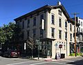 | 2 February 1981 (#1605) | 28 N Union St, Lambertville, NJ 08530 40°13′12″N74°33′51″W / 40.220066°N 74.564200°W | Lambertville | Built in 1839, the building is now an antiques mall. [6] |
Mercer County
See National Register of Historic Places listings in Mercer County, New Jersey for the national list.
| [1] | Name on the Register | Image | Date listed [2] | Location | City or town | Description |
|---|---|---|---|---|---|---|
| 1 | Shaky Bridge |  | 24 March 2004 (#4313) | near Trenton Water Filtration Plant at the Calhoun Street Bridge 40°13′24″N74°46′48″W / 40.2232316°N 74.7800616°W | Trenton | (spans approx. 20 feet) demonstration project from John A. Roebling. [7] |
| 2 | Yard Avenue Historic District | 25 April 1983 (#1809) | 40°13′13″N74°45′16″W / 40.22034°N 74.75449°W | Trenton | Demolished. [8] It was petitioned to be de-certified. [9] It is now known as Station Plaza. [10] There was a book published in the early 80's. [11] It is no longer listed on the map. [12] In included an area including Carroll street, Southard Street, Yard Avenue, South Clinton Avenue, and East State Street, and was considered to be "Railroad Age". [13] | |
| 3 | Waters Edge Archaeological Complex | 3 March 1997 (#3535) | 40°12′26″N74°45′42″W / 40.2071°N 74.7618°W | Trenton | HPO Opinion: 12/19/1975 Smithsonian Institution site registration designation 28-Me-268(ID#3535) [14] It is on the site of Water's Edge residential care facility. [15] at 512 Union Street, Trenton, New Jersey 08611 It is superseded by the Smithsonian Institution site registration designation 28Me273 [17] | |
| 4 | Benevolent Protective Order of Elks, Trenton Lodge 105 |  | 7 March 1988 (#1792) | 120 North Warren Street, Trenton, NJ 40°13′18″N74°45′55″W / 40.221535°N 74.765341°W | Trenton | Construction on the building began in 1910, was completed the following year and formally opened January 1, 1912. [18] |
| 5 | Trenton Trust Company |  | 21 May 2008 (#4786) | 28 West State Street, Trenton, NJ 40°13′15″N74°46′02″W / 40.220723°N 74.767139°W | Trenton | Built in 1928 as Trenton Trust Headquarters. [19] In 1937, Mary Roebling, became the bank's president, making her the first woman to head a major American bank. [20] |
Monmouth County
See National Register of Historic Places listings in Monmouth County, New Jersey for the national list.
| [1] | Name on the Register | Image | Date listed [2] | Location | City or town | Description |
|---|---|---|---|---|---|---|
| 1 | F&JA Masonry Arch Bridge (Applegate Creek) | 30 June 2008 (#3633) | Freehold & Jamesburg Agricultural Railroad over Applegate Creek, MP 18.5 40°14′35″N74°14′59″W / 40.24317°N 74.24965°W | Freehold Township | F&JA Masonry Arch Bridge (Applegate Creek), ID#4829 [21] |
Somerset County
See National Register of Historic Places listings in Somerset County, New Jersey for the national list.
| [1] | Name on the Register | Image | Date listed [2] | Location | City or town | Description |
|---|---|---|---|---|---|---|
| 1 | Raritan Water Power Canal |  | 27 August 2001 (#3633) | Raritan, NJ 08869 40°33′55″N74°38′16″W / 40.56521667°N 74.63778333°W | Raritan | Raritan Water Power Canal Historic District, ID#3633 [22] |