List of the National Register of Historic Places listings in Monmouth County, New Jersey
| Atlantic – Bergen (Closter, Franklin Lakes, Ridgewood, Saddle River, Wyckoff) – Burlington – Camden – Cape May – Cumberland – Essex – Gloucester – Hudson – Hunterdon – Mercer – Middlesex – Monmouth – Morris – Ocean – Passaic – Salem – Somerset – Sussex – Union – Warren |
This is intended to be a complete list of properties and districts listed on the National Register of Historic Places in Monmouth County, New Jersey. Latitude and longitude coordinates of the sites listed on this page may be displayed in an online map. [1]
This National Park Service list is complete through NPS recent listings posted July 26, 2024. [2]
| [3] | Name on the Register [4] | Image | Date listed [5] | Location | City or town | Description |
|---|---|---|---|---|---|---|
| 1 | PS Alexander Hamilton (steamship) |  | March 25, 1977 (#77000887) | Off NJ 36 40°25′19″N74°02′06″W / 40.421944°N 74.035°W | Atlantic Highlands | 1924 steamer that sunk in 1977 near Naval Weapons Station Earle |
| 2 | All Saints' Memorial Church Complex |  | February 15, 1974 (#74001179) | Navesink Ave. and Locust Rd. 40°23′53″N74°01′13″W / 40.398133°N 74.020275°W | Navesink | 1864 Gothic-style Episcopal church |
| 3 | Allaire Village |  | January 11, 1974 (#74001174) | 3 miles (4.8 km) southeast of Farmingdale on NJ 524 40°09′31″N74°07′44″W / 40.158611°N 74.128889°W | Farmingdale | 18th-19th century living history museum |
| 4 | Allen House |  | May 8, 1974 (#74001180) | Broad St. and Sycamore Ave. 40°19′26″N74°03′44″W / 40.323889°N 74.062222°W | Shrewsbury | 1710 tavern operating as a historic house museum, part of the Shrewsbury Historic District |
| 5 | Allenhurst Railroad Station |  | September 17, 1980 (#80002504) | Main St. 40°14′14″N74°00′25″W / 40.237222°N 74.006944°W | Allenhurst | 1897 historic active railroad station |
| 6 | Allenhurst Residential Historic District |  | June 18, 2010 (#10000353) | Roughly bounded by the Atlantic Ocean, Main Street, Cedar Avenue, Hume Street, and Elberon Avenue 40°14′10″N74°00′02″W / 40.236222°N 74.000692°W | Allenhurst | Historic district including 412 contributing properties |
| 7 | Allentown Historic District |  | June 14, 1982 (#82003284) | Portions of North and South Main streets, Church, Pearl and Hamilton streets, Lakeview Drive and Yardville Road 40°10′36″N74°35′14″W / 40.176667°N 74.587222°W | Allentown | Historic district including 219 contributing buildings, including Allentown Mill |
| 8 | Allentown Mill |  | February 14, 1978 (#78001774) | 42 S. Main Street 40°10′34″N74°35′13″W / 40.176111°N 74.586944°W | Allentown | Historic gristmill |
| 9 | Allgor–Barkalow Homestead |  | June 21, 1984 (#84002748) | New Bedford Road 40°10′30″N74°03′52″W / 40.175°N 74.064444°W | Wall Township | Old Wall Historical Society museum |
| 10 | Arburtus Cottage |  | August 18, 2015 (#15000003) | 508 4th Avenue 40°13′25″N74°00′25″W / 40.223633°N 74.006903°W | Asbury Park | Stephen Crane House, Asbury Park Historical Society museum |
| 11 | Asbury Park Commercial Historic District |  | September 30, 2014 (#14000536) | Roughly bounded by 500, 600, 700 blocks, of Bond St., Cookman & Mattison Aves. between Lake & Bangs Aves. 40°12′59″N74°00′43″W / 40.2164°N 74.0119°W | Asbury Park | Encompasses most of downtown Asbury Park |
| 12 | Asbury Park Convention Hall |  | March 2, 1979 (#79001512) | Ocean Ave. 40°13′22″N73°59′56″W / 40.222778°N 73.998889°W | Asbury Park | Actively used 1928 convention center located on the boardwalk |
| 13 | Audenried Cottage |  | March 8, 1991 (#91000117) | 21 Tuttle Ave. 40°09′31″N74°01′21″W / 40.158611°N 74.0225°W | Spring Lake | Part of the Spring Lake as a Coastal Resort Multiple Property Submission (MPS) |
| 14 | Bell Laboratories-Holmdel |  | June 26, 2017 (#16000223) | 101 Crawfords Corner Rd. 40°21′54″N74°10′02″W / 40.36498°N 74.1673°W | Holmdel Township | Former research and development facility now used as a mixed use living and working space known as Bell Works |
| 15 | Bradley Beach Free Public Library | 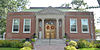 | December 24, 2013 (#13000976) | 511 4th Ave. 40°12′01″N74°00′58″W / 40.200379°N 74.016244°W | Bradley Beach | Actively used |
| 16 | Bradley Beach Station | 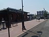 | June 22, 1984 (#84002749) | Between LaReine and Brimley Avenues 40°12′13″N74°01′09″W / 40.203611°N 74.019167°W | Bradley Beach | part of the Operating Passenger Railroad Stations TR |
| 17 | Brielle Road Bridge over the Glimmer Glass |  | April 25, 2008 (#08000336) | Brielle Rd. over The Glimmer Glass 40°06′43″N74°02′45″W / 40.111886°N 74.04577°W | Brielle and Manasquan | 1938 bascule bridge |
| 18 | Brookdale Farm Historic District |  | November 9, 2020 (#100004105) | 805 Newman Springs Road, Lincroft 40°19′58″N74°08′32″W / 40.3328°N 74.1422°W | Middletown Township | 1786 horse farm part of Thompson Park |
| 19 | Maj. John Burrowes Mansion |  | September 29, 1972 (#72000803) | 94 Main St. 40°25′00″N74°13′46″W / 40.416667°N 74.229444°W | Matawan | 1723 mansion site to a 1778 clash between British and Patriots |
| 20 | Camp Evans Historic District |  | March 26, 2002 (#02000274) | 2201 Marconi Rd. (Wall Township) • Boundary increase and decrease (listed August 21, 2012, refnum 12000076): 2201 Marconi Rd. (Wall Township) 40°11′06″N74°03′28″W / 40.185°N 74.057778°W | Wall Township | Former military installation |
| 21 | The Carlton Theatre |  | December 18, 2009 (#09001100) | 99 Monmouth St. 40°20′56″N74°04′13″W / 40.348836°N 74.070364°W | Red Bank Borough | 1926 theater now known as Count Basie Theatre |
| 22 | Chauncy Jerome Jr. Shipwreck Site |  | March 1, 1996 (#96000205) | Address Restricted | Long Branch City | Mid 19th century packet ship |
| 23 | Christ Church |  | November 12, 1971 (#71000511) | 92 Kings Highway 40°23′38″N74°07′05″W / 40.393889°N 74.118056°W | Middletown Township | 1744 historic church |
| 24 | Christ Church (Episcopal), Shrewsbury | 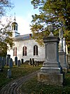 | October 25, 1995 (#95001184) | Jct. of Broad St. and Sycamore Ave. 40°19′25″N74°03′42″W / 40.323611°N 74.061667°W | Shrewsbury | 1769 historic church, part of the Shrewsbury Historic District |
| 25 | Church of the Presidents |  | November 7, 1976 (#76001169) | 1260 Ocean Ave. 40°15′48″N73°59′27″W / 40.263333°N 73.990833°W | Long Branch | Former church that seven presidents attended |
| 26 | Clarksburg Methodist Episcopal Church |  | February 5, 1999 (#99000084) | 512 Cty Rd. 524 40°11′29″N74°27′05″W / 40.191389°N 74.451389°W | Millstone Township | 1845 historic church |
| 27 | Clarksburg School |  | November 12, 1999 (#99001316) | 524 Stagecoach Rd. (Millstone Township) 40°11′28″N74°26′33″W / 40.191111°N 74.4425°W | Clarksburg | 1925 historic school |
| 28 | Dr. Robert W. Cooke Medical Office |  | January 18, 2011 (#10001145) | 67 McCampbell Road 40°20′44″N74°10′20″W / 40.345694°N 74.172139°W | Holmdel | 1823 medical office, Holmdel Historical Society museum |
| 29 | Court Street School |  | August 4, 1995 (#95001003) | Jct. of Court St. and Holmes Terr. 40°15′58″N74°17′01″W / 40.266111°N 74.283611°W | Freehold | 1921 historic school |
| 30 | Coward-Smith House |  | July 6, 1989 (#89000804) | Burlington Path Rd. 40°08′32″N74°28′28″W / 40.142222°N 74.474444°W | Upper Freehold | Crica 1750 historic house |
| 31 | Coward-Hendrickson House | 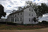 | March 21, 1985 (#85000594) | Address Restricted | Cream Ridge | 1728 historic house |
| 32 | Dempsey Pump House | 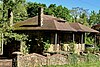 | April 11, 2024 (#100010171) | 55 Hamilton Avenue, Leonardo 40°25′06″N74°03′33″W / 40.418472°N 74.059167°W | Middletown Township | |
| 33 | First Presbyterian Church of Rumson |  | March 3, 2010 (#09000132) | 4 E. River Rd. 40°22′34″N74°00′35″W / 40.376239°N 74.009858°W | Rumson | 1885 historic church |
| 34 | Frederic A. Duggan First Aid and Emergency Squad Building |  | September 18, 1998 (#98001177) | 311 Washington Ave. 40°09′19″N74°01′45″W / 40.155278°N 74.029167°W | Spring Lake | Oldest first aid squad in the country, built in 1934 |
| 35 | Fisk Chapel |  | October 29, 1975 (#75001146) | Cedar Ave. 40°21′38″N74°02′28″W / 40.360556°N 74.041111°W | Fair Haven | 1882 African-American historic church |
| 36 | Fort Hancock and the Sandy Hook Proving Ground Historic District |  | April 24, 1980 (#80002505) | NJ 36 40°26′55″N73°59′40″W / 40.448611°N 73.994444°W | Sandy Hook | Part of the Gateway National Recreation Area, one of 5 sites operated by the National Park Service in New Jersey |
| 37 | Fort Hancock U.S. Life Saving Station | 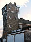 | November 30, 1981 (#81000080) | North of Highlands on Sandy Hook 40°25′35″N73°59′05″W / 40.426389°N 73.984722°W | Highlands | 1894 structure part of the Fort Hancock and the Sandy Hook Proving Ground Historic District |
| 38 | Fort Monmouth Historic District |  | March 12, 2014 (#13000764) | Oceanport Ave. 40°18′50″N74°02′42″W / 40.314°N 74.045°W | Oceanport | Former army fort installation being readapted as a mixed used development |
| 39 | T. Thomas Fortune House |  | December 8, 1976 (#76001171) | 94 W. Bergen Pl. 40°20′29″N74°04′26″W / 40.341389°N 74.073889°W | Red Bank | 19th century historic house |
| 40 | Gregory Primary School |  | October 24, 2012 (#12000880) | 157 N. 7th Ave. 40°18′30″N73°59′47″W / 40.308298°N 73.99631°W | Long Branch | Historic school now used as senior housing |
| 41 | Grover House |  | October 10, 2002 (#02001121) | 940 W. Front Street 40°20′41″N74°06′15″W / 40.344722°N 74.104167°W | Middletown Township | 1730 historic house |
| 42 | Murry Guggenheim House | 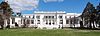 | March 28, 1978 (#78001778) | Cedar and Norwood Avenues 40°16′56″N74°00′12″W / 40.282222°N 74.003333°W | West Long Branch | Also known as the Guggenheim Library, at Monmouth University |
| 43 | Hankinson–Moreau–Covenhoven House |  | May 1, 1974 (#74001175) | 150 W. Main Street 40°15′07″N74°17′19″W / 40.251944°N 74.288611°W | Freehold | 1752 historic house known for being used by Henry Clinton during the American Revolution |
| 44 | Holmdel Dutch Reformed Church |  | October 22, 1980 (#80002506) | 41 Main St. 40°20′43″N74°11′04″W / 40.345278°N 74.184444°W | Holmdel | 1838 historic church |
| 45 | Holmes–Hendrickson House |  | April 26, 1978 (#78001776) | Longstreet Road, adjacent to Holmdel Park 40°22′20″N74°11′09″W / 40.372222°N 74.185833°W | Holmdel | 1754 farmhouse |
| 46 | Holy Trinity Episcopal Church |  | March 8, 1991 (#91000116) | Jct. of Monmouth and Third Aves. 40°08′46″N74°01′52″W / 40.146111°N 74.031111°W | Spring Lake | Part of the Spring Lake as a Coastal Resort MPS |
| 47 | Horn Antenna |  | December 20, 1989 (#89002457) | Off Garden State Parkway in Crawford Hill Facility 40°23′29″N74°11′07″W / 40.391389°N 74.185278°W | Holmdel | 1960s horn antenna known for discovering cosmic microwave background radiation |
| 48 | House at 364 Cedar Avenue |  | November 1, 1979 (#79001514) | 364 Cedar Avenue 40°16′53″N74°00′04″W / 40.281389°N 74.001111°W | Long Branch | Demolished c. 2009 |
| 49 | Imlaystown Historic District |  | January 3, 1985 (#85000032) | Roughly Imlaystown-Davis Station Rd., and Imlaystown-Red Valley Rd. 40°09′50″N74°30′41″W / 40.163889°N 74.511389°W | Imlaystown | Historic district with 29 contributing properties, including Salter's Mill |
| 50 | Jersey Homesteads Historic District |  | December 5, 1983 (#83004053) | All that area within the corporate boundaries of the Borough of Roosevelt 40°13′17″N74°28′26″W / 40.221389°N 74.473889°W | Roosevelt | New Deal era planned community |
| 51 | Kovenhoven |  | April 26, 1974 (#74001176) | North of Holmdel off NJ 34 40°21′56″N74°11′43″W / 40.365556°N 74.195278°W | Holmdel | 1699 historic house |
| 52 | Lauriston |  | March 8, 2002 (#02000134) | 91 Rumson Road Coordinates missing | Rumson | Historic mansion demolished in 2023 |
| 53 | Little Silver Station |  | June 22, 1984 (#84002754) | Sycamore and Branch Aves. 40°19′35″N74°02′28″W / 40.326389°N 74.041111°W | Little Silver | part of the Operating Passenger Railroad Stations TR |
| 54 | Longstreet Farm |  | November 29, 1979 (#79003255) | Longstreet Road at Roberts Road, Holmdel Park 40°22′08″N74°11′02″W / 40.368889°N 74.183889°W | Holmdel | 18th century historic living history farm |
| 55 | MacGregor-Tallman House | 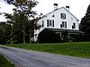 | September 5, 1985 (#85002003) | 407 Monmouth Rd. 40°16′52″N74°01′09″W / 40.281111°N 74.019167°W | West Long Branch | 18th century historic house |
| 56 | MacLeod–Rice House | 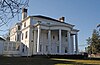 | December 3, 2018 (#100003203) | 900 Leonardville Road, Leonardo 40°24′39″N74°03′18″W / 40.410722°N 74.055111°W | Middletown Township | |
| 57 | Martin Maloney Cottage |  | October 26, 1992 (#91000115) | 101 Morris Avenue 40°09′05″N74°01′29″W / 40.151389°N 74.024722°W | Spring Lake | Part of the Spring Lake as a Coastal Resort MPS |
| 58 | Manasquan Friends Meetinghouse and Burying Ground |  | July 22, 1992 (#91000902) | NJ 35 at Manasquan Circle 40°07′58″N74°03′53″W / 40.132778°N 74.064722°W | Wall Township | 1884 meeting house |
| 59 | Matawan Station |  | June 22, 1984 (#84002756) | Between Main and Atlantic Avenues 40°25′12″N74°13′27″W / 40.42°N 74.224167°W | Matawan | part of the Operating Passenger Railroad Stations TR |
| 60 | Merino Hill House and Farm | 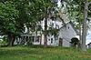 | February 11, 1988 (#87002561) | Allentown-Clarksburg Rd., CR 524 40°11′08″N74°30′06″W / 40.185556°N 74.501667°W | Wrightsville | Actively used 1735 farm |
| 61 | Middletown Village Historic District |  | May 3, 1974 (#74001177) | Irregular pattern on both sides of Kings Highway, south and west of NJ 35 40°23′38″N74°06′48″W / 40.393889°N 74.113333°W | Middletown Township | Historic district containing 15 contributing properties, including Christ Church |
| 62 | Monmouth Battlefield | 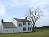 | October 15, 1966 (#66000467) | Northwest of Freehold on NJ 522, west of Rte. 9 40°16′23″N74°18′50″W / 40.273056°N 74.313889°W | Freehold | Site of the Battle of Monmouth |
| 63 | Monmouth Boat Club |  | August 16, 1994 (#94000857) | Union St. east of Boat Club Ct. 40°21′12″N74°04′01″W / 40.353333°N 74.066944°W | Red Bank | Actively used 1879 historic boat club building |
| 64 | Navesink Historic District |  | September 5, 1975 (#75001148) | Roughly triangular area including both sides of Monmouth and Locust Avenues to the junction with Hillside and Grand Avenues 40°24′00″N74°02′08″W / 40.400000°N 74.035556°W | Navesink | Historic district containing 96 contributing properties |
| 65 | Navesink Light Station |  | February 17, 2006 (#06000237) | 100 Government-Lighthouse Road 40°23′46″N73°59′09″W / 40.396222°N 73.985778°W | Highlands | 1862 non-operational dual lighthouse, also known as Navesink Twin Lights |
| 66 | Navesink Military Reservation Historic District |  | October 13, 2015 (#15000011) | Grand Tour Road and Portland Road, Hartshorne Woods Park 40°23′26″N73°59′20″W / 40.390556°N 73.988889°W | Middletown Township | Former military installation located within Hartshorne Woods Park |
| 67 | North Long Branch School-Primary No. 3 |  | July 28, 1999 (#99000906) | 469 Church St. 40°19′15″N73°58′44″W / 40.320833°N 73.978889°W | Long Branch | 1891 historic school |
| 68 | North Shrewsbury Ice Boat and Yacht Club |  | October 31, 2019 (#08000179) | 9 Union St. 40°21′10″N74°04′00″W / 40.3528°N 74.0666°W | Red Bank | Longest standing active iceboat club in the world, established in 1880 |
| 69 | Ocean Grove Camp Meeting Association District |  | April 12, 1976 (#76001170) | Bounded by Fletcher Lake, NJ 71, Lake Wesley, and the Atlantic Ocean 40°12′34″N74°00′47″W / 40.209444°N 74.013056°W | Ocean Grove | Consists of the entire unincorporated community of Ocean Grove, a late 19th century Christian resort town |
| 70 | Old Kentuck |  | November 6, 1973 (#73001118) | Pleasant Valley Road, Pleasant Valley 40°21′58″N74°13′12″W / 40.366000°N 74.220000°W | Marlboro | 1770 historic house, Asher Holmes House |
| 71 | Old Mill at Tinton Falls |  | April 24, 1973 (#73001119) | 1205 Sycamore Ave. 40°18′16″N74°06′03″W / 40.304444°N 74.100833°W | Tinton Falls | 1676 historic mill now operating as an MJ's restaurant, part of the Tinton Falls Historic District |
| 72 | Old Scots Burying Ground | 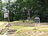 | August 15, 2001 (#01000841) | Gordon's Corner Road 40°20′23″N74°15′35″W / 40.339722°N 74.259722°W | Marlboro | 1685 historic cemetery |
| 73 | Palace Amusements |  | November 22, 2000 (#00001406) | 201-207 Lake Ave. 40°13′04″N74°00′13″W / 40.217778°N 74.003611°W | Asbury Park | Demolished in 2004 |
| 74 | Parker Homestead | 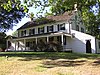 | December 28, 2011 (#11000966) | 235 Rumson Rd. 40°20′36″N74°02′26″W / 40.343358°N 74.040564°W | Little Silver | 1720 historic farmstead |
| 75 | Players Boat Club |  | June 17, 2019 (#100004058) | 925 River Rd. 40°22′07″N74°01′48″W / 40.3685°N 74.0301°W | Fair Haven | Active boat club dating back to 1910 |
| 76 | Probasco-Dittner Farmstead |  | February 1, 2006 (#05001564) | 61 Bucks Mill Rd. 40°17′15″N74°12′14″W / 40.2875°N 74.203889°W | Colts Neck | Mid-late 18th century farmstead |
| 77 | Portland Place |  | December 12, 2012 (#12001033) | 220 Hartshorne Rd. 40°23′25″N74°00′21″W / 40.390293°N 74.005732°W | Middletown Township | 1720 country house on a former farmstead |
| 78 | Anthony Reckless Estate | 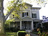 | June 3, 1982 (#82003286) | 164 Broad Street 40°20′48″N74°03′55″W / 40.3465402°N 74.0653189°W | Red Bank | 1870 historic house, now operating as the Woman's Club of Red Bank |
| 79 | Red Bank Passenger Station |  | May 28, 1976 (#76001172) | Ridge and Monmouth Sts. 40°20′52″N74°04′30″W / 40.347778°N 74.075°W | Red Bank | part of the Operating Passenger Railroad Stations TR |
| 80 | River Street School |  | April 14, 1995 (#95000410) | 60 River St. 40°20′35″N74°04′36″W / 40.343056°N 74.076667°W | Red Bank | Historic school now home to low-income apartments |
| 81 | Romer Shoal Light Station |  | January 24, 2007 (#06001304) | In Lower New York Bay, 3.8 miles (6.1 km) north of Sandy Hook 40°30′46″N74°00′50″W / 40.512778°N 74.013889°W | Highlands Borough | part of the Light Stations of the United States MPS |
| 82 | Salter's Mill | 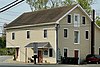 | September 29, 1980 (#80002507) | Imlaystown-Davis Station Road 40°09′54″N74°30′51″W / 40.165°N 74.514167°W | Imlaystown | 1897 historic gristmill, part of the Imlaystown Historic District |
| 83 | Sandy Hook Archeological Site |  | June 26, 1998 (#98000704) | Address Restricted | Highlands | Part of Sandy Hook |
| 84 | Sandy Hook Light | 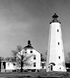 | October 15, 1966 (#66000468) | Fort Hancock Military Reservation 40°27′42″N74°00′09″W / 40.461667°N 74.0025°W | Sandy Hook | Oldest working lighthouse in the United States, built in 1764, part of the Gateway National Recreation Area |
| 85 | Seabright Lawn Tennis and Cricket Club |  | July 9, 1991 (#91000883) | Jct. of Rumson Rd. and Tennis Court Ln. 40°21′59″N73°59′01″W / 40.366389°N 73.983611°W | Rumson | 1877 active historic private sports club, oldest active lawn tennis club in the United States |
| 86 | Seabrook–Wilson House |  | October 29, 1974 (#74001178) | 119 Port Monmouth Road, Port Monmouth 40°26′21″N74°05′35″W / 40.439167°N 74.093056°W | Middletown Township | |
| 87 | Shadow Lawn |  | March 28, 1978 (#78001780) | Cedar and Norwood Aves. 40°16′46″N74°00′19″W / 40.279444°N 74.005278°W | West Long Branch | Also known as Woodrow Wilson Hall, at Monmouth University |
| 88 | Shrewsbury Historic District |  | July 17, 1978 (#78001779) | Broad and Sycamore Streets 40°19′23″N74°03′49″W / 40.323056°N 74.063611°W | Shrewsbury | Historic district encompassing 47 contributing buildings, including the Christ Church, the Allen House, and the Wardell House |
| 89 | Shrewsbury Township Hall |  | December 8, 1980 (#80002508) | 51 Monmouth St. 40°20′57″N74°04′06″W / 40.349167°N 74.068333°W | Red Bank | 1892 former town hall, now used as a performing arts center for Red Bank Catholic High School |
| 90 | Squan Beach Life-Saving Station #9 |  | March 5, 2008 (#08000135) | Ocean & 2nd Aves. 40°07′03″N74°02′02″W / 40.1175°N 74.033889°W | Manasquan | 1902 lifeguard station |
| 91 | St. George's-by-the-River Episcopal Church | 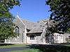 | February 13, 2007 (#07000045) | 7 Lincoln Ave. 40°21′48″N73°58′43″W / 40.363333°N 73.978611°W | Rumson | 1907 historic church |
| 92 | St. James Memorial Church of Eatontown |  | February 17, 1978 (#78001775) | 69 Broad St. 40°18′22″N74°03′26″W / 40.306111°N 74.057222°W | Eatontown | 1866 historic church |
| 93 | St. John's Episcopal Church |  | December 27, 1990 (#90001374) | Little Silver Point Rd. 40°20′02″N74°01′58″W / 40.333889°N 74.032778°W | Little Silver | 1876 historic church |
| 94 | St. Peter's Episcopal Church |  | March 19, 1998 (#98000256) | 31 Throckmorton St. 40°15′34″N74°16′34″W / 40.259444°N 74.276111°W | Freehold Borough | 1771 historic church |
| 95 | Steinbach–Cookman Building |  | July 8, 1982 (#82003285) | Cookman Avenue 40°12′59″N74°00′37″W / 40.216389°N 74.010278°W | Asbury Park | Early 20th century former flagship store of the Steinbach department store chain, part of the Asbury Park Commercial Historic District |
| 96 | George Taylor House |  | April 29, 1994 (#94000392) | 74 Broadway 40°16′03″N74°16′02″W / 40.2675°N 74.267222°W | Freehold Borough | 1870 historic house |
| 97 | Tinton Falls Historic District |  | November 10, 1977 (#77000888) | Irregular pattern along Tinton and Sycamore Avenues 40°18′18″N74°05′57″W / 40.305°N 74.099167°W | Tinton Falls | Historic district containing the Old Mill at Tinton Falls |
| 98 | The Towers |  | August 20, 2012 (#12000529) | 27 Prospect Circle 40°24′44″N74°02′01″W / 40.412173°N 74.033487°W | Atlantic Highlands | 1894 house known as the Strauss Mansion |
| 99 | Trinity Church |  | August 6, 2014 (#14000465) | 503 Asbury Ave. 40°13′11″N74°00′29″W / 40.2197°N 74.0081°W | Asbury Park | 1908 historic stone church |
| 100 | Union Schoolhouse |  | June 23, 1976 (#76001173) | West of Red Bank on Middletown-Lincroft Road 40°21′57″N74°07′14″W / 40.365833°N 74.120556°W | Middletown Township | 1842 historic schoolhouse, also known as the Little Red Schoolhouse |
| 101 | Upper Freehold Baptist Meeting |  | April 21, 1975 (#75001147) | East of Imlaystown on Yellow Meetinghouse and Red Valley roads 40°10′08″N74°28′28″W / 40.168889°N 74.474444°W | Upper Freehold Township | 1720 historic church also known as Ye Olde Yellow Meeting House |
| 102 | Upper Meeting House of the Baptist Church of Middletown |  | December 7, 1990 (#87002573) | 40 Main St. 40°20′41″N74°11′11″W / 40.344722°N 74.186389°W | Holmdel | 1809 historic church |
| 103 | Village Inn |  | November 13, 1972 (#72000802) | Water and Main Streets 40°17′50″N74°21′34″W / 40.297222°N 74.359444°W | Englishtown | 1732 historic house also known as Davis Tavern and Robert Newell House |
| 104 | Walker-Combs-Hartshorne Farmstead | 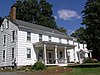 | October 4, 1990 (#90001474) | 189 Wemrock Rd. 40°14′51″N74°18′22″W / 40.2475°N 74.306111°W | Freehold | 1686 historic farmstead |
| 105 | Walnford |  | June 29, 1976 (#76001167) | South of Allentown off CR 539 40°08′05″N74°33′32″W / 40.134722°N 74.558889°W | Walnford | Historic district containing 16 contributing buildings |
| 106 | Wardell House |  | July 24, 1974 (#74001181) | 419 Sycamore Ave. 40°19′22″N74°03′46″W / 40.322778°N 74.062778°W | Shrewsbury | 1764 historic house, part of the Shewsbury Historic District |
| 107 | Water Witch Club Casino |  | August 13, 1990 (#90001219) | Junction of E. Twin Road and W. Twin Road 40°24′01″N73°59′36″W / 40.400278°N 73.993333°W | Middletown Township | 1905 historic clubhouse, used as a venue today, focal point of the Water Witch Club Historic District |
| 108 | Water Witch Club Historic District |  | March 12, 2004 (#04000147) | Roughly bounded by NJ 36, Water Witch Dr., Sea View Terrace, Park Way, Windlass Path and Serpentine Dr. 40°24′02″N73°59′49″W / 40.400556°N 73.996944°W | Middletown Township | Historic district containing numerous contributing buildings, including the Water Witch Club Casino |
| 109 | Robert White House |  | March 7, 2012 (#12000077) | 20 South St. 40°20′45″N74°03′43″W / 40.3458°N 74.061833°W | Red Bank | 1790s historic home, oldest in Red Bank |
| 110 | Winsor Building |  | September 13, 1979 (#79001513) | 400-420 Main St. and 715-131 Bangs Ave 40°13′02″N74°00′42″W / 40.217222°N 74.011667°W | Asbury Park | 1904 historic mixed-used building |
| 111 | George Wurts Summer Home |  | December 28, 1989 (#89002162) | 306 Eighth Ave. 40°13′41″N74°00′07″W / 40.228056°N 74.001944°W | Asbury Park | 19th century summer home for |