
West Freehold is an unincorporated community and census-designated place (CDP) within Freehold Township, in Monmouth County, New Jersey, United States. As of the 2020 census, the CDP's population was 13,596. Due to the community's proximity to the Battle of Monmouth, West Freehold is home to several important historical structures, which have been preserved in the West Freehold Village Historic District.

Samuel Lewis Southard was a prominent American statesman of the early 19th century, serving as a U.S. Senator, Secretary of the Navy, and the tenth governor of New Jersey. He also served as President pro tempore of the Senate, and was briefly first in the presidential line of succession.

The Airport Circle is a traffic circle in Pennsauken Township, New Jersey, United States. It is located at the intersection of Route 38, U.S. Route 30 (US 30), and US 130, close to the Camden border. South of the circle, US 30 and US 130 run concurrently until they reach the former Collingswood Circle in Collingswood. The Airport Circle opened in 1927 and is the first of is kind in the United States. It is named for Camden Central Airport whose terminal building was located beside the circle, to the south-east. The circle has been modified to include traffic lights and ramps to help ease traffic congestion.
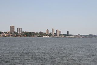
North Hudson is the area in the northern part of Hudson County, New Jersey, situated on the west bank of the Hudson River, mostly atop the Hudson Palisades. It comprises Weehawken, Union City, West New York, Guttenberg, and North Bergen.

New Lisbon is an unincorporated community located within Pemberton Township in Burlington County, in the U.S. state of New Jersey. It is a settlement along Four Mile Road where it intersects Mount Misery Road. The community is located along the Philadelphia and Long Branch Railway, later a part of the Pennsylvania Railroad, and featured a train station.
Monroeville is an unincorporated community located within portions of Elk Township in Gloucester County and Upper Pittsgrove Township in Salem County, in the U.S. state of New Jersey. The area is served as United States Postal Service ZIP Code 08343. Monroeville is mostly filled with wooded areas and farms.

Perrineville is an unincorporated community located within Millstone Township in Monmouth County, in the U.S. state of New Jersey. The area is served as United States Postal Service ZIP Code 08535.
Bonhamtown is a section of Edison Township in Middlesex County, New Jersey, United States.

Hornerstown is an unincorporated community located within Upper Freehold Township in Monmouth County, in the U.S. state of New Jersey. Hornerstown is located near Cream Ridge and uses the 08514 ZIP code.

James Jay Mapes was an American chemist, inventor and educator, mostly known for his achievements in scientific agriculture.
Wilburtha is a section of Ewing Township in Mercer County, in the U.S. state of New Jersey. Located where Wilburtha Road crosses the Delaware and Raritan Canal, it is one of the oldest settlements in Ewing Township and developed due to the construction of the canal in the early 19th century. The community was known as Greensburg before adopting its current name in 1883. The Yardley–Wilburtha Bridge once connected Wilburtha to Yardley, Pennsylvania on the other side of the Delaware River. The Belvidere Delaware Railroad once passed through the village. Today, Wilburtha is primarily a residential neighborhood consisting of detached, single-family homes, the majority of which were built in the 1950s through the early 1980s. There are still many Georgian and Federal-style homes found in the area.

Brindletown is an unincorporated community located within Plumsted Township, in Ocean County, in the U.S. state of New Jersey. Brindletown was once a village home to a hotel, a mill, and large estates overlooking Brindle Lake. Brindletown was purchased by the federal government to expand Camp Dix in the 1920s. The site of the original Brindletown is within a weapons training site though the site of the current Brindletown is accessible to the public. The current settlement is centered about the intersection of Long Swamp Road and Carter Lane to the north of the original site. Houses line Long Swamp Road and other surrounding roads in the area while some farms are found to the north of Long Swamp Road. The portion of the community within the confines of Fort Dix is mostly forest.

Cranbury Station is an unincorporated community located within Cranbury Township in Middlesex County, in the U.S. state of New Jersey. The area immediately around the site of the former railroad station along the Camden and Amboy Railroad contains agricultural businesses and small homes. Hightstown-Cranbury Station Road is the main road through the settlement paralleling the railroad and Station Road as a major road heading east and west through the area. Modern warehouses line Station Road and the nearby New Jersey Turnpike west of the station while large housing developments are located east of here in Monroe Township.
New Durham was an unincorporated community and now a neighborhood located within Edison in Middlesex County, New Jersey, United States, south of Dismal Swamp.

Bergerville is an unincorporated community located within Howell Township in Monmouth County, in the U.S. state of New Jersey. The area was originally developed as a resort bungalow community in the first half of the 20th century.

Fairfield is an unincorporated community located within Howell Township in Monmouth County, in the U.S. state of New Jersey. The community is centered on the intersection of County Route 524 (CR 524) and Ketchum Road, where the Colonial Era Our House Tavern is located. The area includes several small businesses, township offices and schools. There are also small farms and residential developments in the area. Fairfield was a stop on the Freehold and Jamesburg Agricultural Railroad.

Freewood Acres is an unincorporated community located within Howell Township in Monmouth County, in the U.S. state of New Jersey. The area is made up of mostly single-story homes arranged along a street grid in the northern reaches of the Pine Barrens. U.S. Route 9 runs through the center of the community just north of its interchange with Interstate 195. The Land O'Pines Elementary School and Manasquan Reservoir County Park exist to the east of the community. It became the center of the Kalmyk American community in the latter part of the 20th century.

Red Valley is an unincorporated community located within Upper Freehold Township in Monmouth County, in the U.S. state of New Jersey. The settlement is located at the intersection of County Route 526 and Red Valley Road (south) and Yellow Meetinghouse Road (north) near the township's eastern border with Millstone Township. Except for some single-family houses located along the roads in the area, the area is primarily made up of farmland.

Comical Corner or Comical Corners is an unincorporated community located within Pemberton Township in Burlington County, in the U.S. state of New Jersey. The site of the actual corners is at the intersection of Pemberton Road and Arneys Mount Road. The original name may have been "Conical Corner" based on the cone-like shape of the skewed intersection but had turned to "Comical Corner" based on a mishearing. The area, located just to the north of Pemberton Borough, is mostly rural and is surrounded by farmland on the two obtuse sides of the intersection.


