
Allenhurst is a borough located on the Jersey Shore, in Monmouth County, in the U.S. state of New Jersey. The settlement was named after resident Abner Allen and was incorporated as a borough by an act of the New Jersey Legislature on April 26, 1897, from portions of Ocean Township. As of the 2020 United States census, the borough's population was 472, a decrease of 24 (−4.8%) from the 2010 census count of 496, which in turn reflected a decline of 222 (−30.9%) from the 718 counted in the 2000 census.

Avon-by-the-Sea is a borough in Monmouth County, in the U.S. state of New Jersey. As of the 2020 United States census, the borough's population was 1,933, an increase of 32 (+1.7%) from the 2010 census count of 1,901, which in turn reflected a decline of 343 (−15.3%) from the 2,244 counted in the 2000 census.

Belmar is a borough located on the Jersey Shore in Monmouth County, in the U.S. state of New Jersey. As of the 2020 United States census, the borough's population was 5,907, an increase of 113 (+2.0%) from the 2010 census count of 5,794, which in turn reflected a decline of 251 (−4.2%) from the 6,045 counted in the 2000 census.

Interlaken is a borough situated in the Jersey Shore region, within Monmouth County, in the U.S. state of New Jersey. As of the 2020 United States census, the borough's population was 828, an increase of 8 (+1.0%) from the 2010 census count of 820, which in turn had reflected a decline of 80 (−8.9%) from the 900 counted in the 2000 census.

Loch Arbour is a village situated on the Jersey Shore in Monmouth County, in the U.S. state of New Jersey. As of the 2020 United States census, the village's population was 224, an increase of 30 (+15.5%) from the 2010 census count of 194, which had in turn reflected a decline of 86 (−30.7%) from the 280 recorded at the 2000 census.

Middletown Township is a township in northern Monmouth County, in the U.S. state of New Jersey. As of the 2020 United States census, the township was the state's 20th-most-populous municipality and the largest in the county, with a population of 67,106, an increase of 584 (+0.9%) from the 2010 census count of 66,522, which in turn reflected an increase of 195 residents (0.3%) from its population of 66,327 at the 2000 census, when it was the state's 17th-most-populous municipality.

Monmouth Beach is a borough in Monmouth County, in the U.S. state of New Jersey, situated on the Jersey Shore in Central Jersey. As of the 2020 United States census, the borough's population was 3,174, a decrease of 105 (−3.2%) from the 2010 census count of 3,279, which in turn had reflected a decline of 316 (−8.8%) from the 3,595 counted at the 2000 census.

Neptune Township is a township in Monmouth County, in the U.S. state of New Jersey. As of the 2020 United States census, the township's population was 28,061, an increase of 126 (+0.5%) from the 2010 census count of 27,935, which in turn reflected an increase of 245 (+0.9%) from the 27,690 counted in the 2000 census.

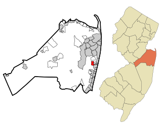
Ocean Township is a township situated on the Jersey Shore in east central Monmouth County, within the U.S. state of New Jersey. The township is a bedroom suburb of New York City. Ocean Township has no central downtown and consists of three main unincorporated communities: Oakhurst, Wanamassa, and Wayside. The township is divided into two ZIP codes, 07755 (Oakhurst) and 07712. Small portions have Allenhurst (07711), Deal (07723) and Long Branch (07740) ZIP codes.
Wanamassa is an unincorporated community and census-designated place (CDP) within Ocean Township, in Monmouth County, New Jersey, United States. As of the 2020 census, the CDP's population was 4,344. The community was named for Wanamassa, a Native American leader of the 17th century.

West Long Branch is a borough situated within the Jersey Shore region, within Monmouth County, in the U.S. state of New Jersey. As of the 2020 United States census, the borough's population was 8,587, its highest decennial count ever and an increase of 490 (+6.1%) from the 2010 census count of 8,097, which in turn reflected a decline of 161 (−1.9%) from the 8,258 counted in the 2000 census. West Long Branch is the home of Monmouth University.
Bradley Beach is a borough in Monmouth County, in the U.S. state of New Jersey. As of the 2020 United States census, the borough's population was 4,282, a decrease of 16 (−0.4%) from the 2010 census count of 4,298, which in turn had reflected a decrease of 495 (−10.3%) from the 4,793 counted at the 2000 census. The summer population can reach 30,000.

Deal is a borough situated on the Jersey Shore within Monmouth County, in the U.S. state of New Jersey. The community was settled by Europeans in the mid-1660s and named after an English carpenter from Deal, Kent. As of the 2020 United States census, the borough's population was 900, an increase of 150 (+20.0%) from the 2010 census count of 750, which in turn had reflected a decline of 320 (−29.9%) from the 1,070 counted in the 2000 census.

Chatsworth is an unincorporated community located within Woodland Township in Burlington County, New Jersey, United States. The area is served as United States Postal Service ZIP Code 08019. The New Jersey Central's Blue Comet passenger train was wrecked here in 1939. Chatsworth has been called "Capital of the Pine Barrens."

Clarksburg is an unincorporated community located within Millstone Township in Monmouth County, in the U.S. state of New Jersey. The area is served as United States Postal Service ZIP code 08510.

Cliffwood is an unincorporated community located within Aberdeen Township in Monmouth County, New Jersey, United States. The area is served as United States Postal Service ZIP code 07721.
Asbury Park High School is a comprehensive, community public high school serving students in seventh through twelfth grades. It is in a landmark building in Asbury Park, in Monmouth County, in the U.S. state of New Jersey, that was constructed during the New Deal as a model high school campus. It is part of the Asbury Park Public Schools, an Abbott District serving children in pre-kindergarten through twelfth grade. The current school building opened to students in September 1926.

Perrineville is an unincorporated community located within Millstone Township in Monmouth County, in the U.S. state of New Jersey. The area is served as United States Postal Service ZIP Code 08535.

Holmeson is an unincorporated community located within Millstone Township in Monmouth County, in the U.S. state of New Jersey. As it is located along County Route 537 through which the Monmouth–Ocean county line runs down the center, portions of the community are also located in Jackson Township. Owing to its location near Interstate 195 and Six Flags Great Adventure, the community is mostly made up of gas stations, restaurants, and small businesses though the Jackson Premium Outlets occupies land just south of the community.
West Keansburg is an unincorporated community located within Hazlet Township in Monmouth County, in the U.S. state of New Jersey. Its total land area is estimated at 1.667 square miles (4.32 km2) and it includes portions of the township east of Waackaack Creek and some parts north of Route 36, as well as some other parts in northeast Hazlet. As of the 2000 United States Census, West Keansburg had a population of 14,423, which is over half of Hazlet's total population of 21,165.


