
Lawrenceville is an unincorporated community and census-designated place (CDP) within Lawrence Township in Mercer County, in the U.S. state of New Jersey. The community is situated roughly halfway between Princeton and Trenton. Lawrenceville is part of the Trenton–Princeton metropolitan area within the New York combined statistical area; however, the CDP actually is located approximately 15 miles closer to Philadelphia than to New York City, and as with the remainder of Mercer County, lies within the Federal Communications Commission's Philadelphia Designated Market Area. As of the 2020 census, the CDP's population was 3,751, a decrease of 136 (−3.5%) from the 3,887 recorded at the 2010 census, which in turn had reflected a decrease of 194 (−4.8%) from the 4,081 counted in the 2000 census.

Jersey County is a county located in the U.S. state of Illinois. At the 2020 census, it had a population of 21,512. The county seat and largest community is Jerseyville, with a population of 8,337 in 2010. The county's smallest incorporated community is Otterville, with a population of 87.

Jerseyville is the largest city in and the county seat of Jersey County, Illinois, United States. At the 2020 census, the city had a total population of 8,337.
Howell Township is a township in Monmouth County, in the U.S. state of New Jersey. The township is the largest municipality in the county by total area, comprising about 61.21 square miles (158.5 km2). It is located in the New York metropolitan area and has been a steadily growing bedroom community of New York City. As of the 2020 United States census, the township's population was 53,537, its highest decennial count ever and an increase of 2,462 (+4.8%) from the 2010 census count of 51,075, which in turn reflected an increase of 2,172 (+4.4%) from the 48,903 counted in the 2000 census.
Wall Township is a township within Monmouth County, in the U.S. state of New Jersey. Crisscrossed by several different highways within the heart of the Jersey Shore region, the township is a transportation hub of Central New Jersey and a bedroom suburb of New York City, in the New York Metropolitan Area. As of the 2020 United States census, Wall Township's population was 26,525, its highest decennial count ever and an increase of 361 (+1.4%) from the 2010 census count of 26,164, which in turn reflected an increase of 903 (+3.6%) from the 25,261 counted in the 2000 census.

West Freehold is an unincorporated community and census-designated place (CDP) within Freehold Township, in Monmouth County, New Jersey, United States. As of the 2010 United States Census, the CDP's population was 13,613. Due to the community's close proximity to the Battle of Monmouth, West Freehold is home to several important historical structures, which have been preserved in the 'West Freehold Village Historic District'. The historically preserved Monmouth Battlefield, along with the historic villages of Clarksburg, Englishtown, Smithburg and Tennent are a short distance away.

Ramtown is a census-designated place and unincorporated community located within Howell Township, in Monmouth County, in the U.S. state of New Jersey. As of the 2010 United States Census, the CDP's population was 6,242.

Bridgeport is a census-designated place (CDP) and unincorporated community that is part of Logan Township, in Gloucester County, in the U.S. state of New Jersey. At the 2020 United States census, the population of the CDP was 389. in the 2010 census, the population was 504.

Clarksburg is an unincorporated community located within Millstone Township in Monmouth County, in the U.S. state of New Jersey. The area is served as United States Postal Service ZIP code 08510.

Keasbey is a census-designated place (CDP) and unincorporated community in Woodbridge Township, Middlesex County, New Jersey, United States. It is located in the western outskirts of adjacent Perth Amboy. As of the 2020 census, the CDP's population was 3,027. Many Hispanic / Latino families have relocated from Perth Amboy to Keasbey.

Adelphia is an unincorporated community located in northern Howell Township, Monmouth County, in the U.S. state of New Jersey. The area is served as United States Postal Service ZIP code 07710. The community borders Freehold Township, and residents who reside in Adelphia use a Freehold mailing address.
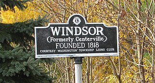
Windsor is a small historic unincorporated community and census-designated place (CDP) located within Robbinsville Township in Mercer County, in the U.S. state of New Jersey. The area is served as United States Postal Service ZIP Code 08561. As of the 2020 United States census, the CDP's population was 330, an increase of 104 (+46.0%) above the 226 counted at the 2010 census. The community, covering 570 acres (230 ha), was added to the National Register of Historic Places in 1992.

Jersey Township is one of eleven townships in Jersey County, Illinois, United States. As of the 2010 census, its population was 10,165 and it contained 4,398 housing units.
Squankum is an unincorporated community located within Howell Township in Monmouth County, in the U.S. state of New Jersey. The name Squankum was used for a town in Gloucester County, which was changed to present day Williamstown, due to postal regulations that prohibited the two towns from having the same name.
Ardena is an unincorporated community located within Howell Township in Monmouth County, in the U.S. state of New Jersey. The community is located along County Route 524 near Vanderveer Road in the western part of the township. The area consists of about half farmland and half residential developments.

Bergerville is an unincorporated community located within Howell Township in Monmouth County, in the U.S. state of New Jersey. The area was originally developed as a resort bungalow community in the first half of the 20th century.

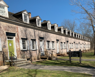
Eayrestown is an unincorporated community located within Lumberton Township in Burlington County, in the U.S. state of New Jersey. The settlement is named for Richard and Elizabeth Eayres, the first settlers of the site in the 1600s. It was also the first settlement in what is now Lumberton Township. The settlement, located along the South Branch Rancocas Creek, was the site of numerous saw and gristmills early in its history and a picnic grove that attracted people from around the area. Today, numerous farms and housing developments dot the area.

Fairfield is an unincorporated community located within Howell Township in Monmouth County, in the U.S. state of New Jersey. The community is centered on the intersection of County Route 524 (CR 524) and Ketchum Road, where the Colonial Era Our House Tavern is located. The area includes several small businesses, township offices and schools. There are also small farms and residential developments in the area. Fairfield was a stop on the Freehold and Jamesburg Agricultural Railroad.

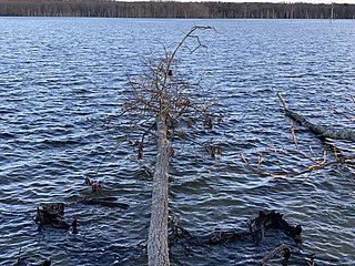
Freewood Acres is an unincorporated community located within Howell Township in Monmouth County, in the U.S. state of New Jersey. The area is made up of mostly single-story homes arranged along a street grid in the northern reaches of the Pine Barrens. U.S. Route 9 runs through the center of the community just north of its interchange with Interstate 195. The Land O'Pines Elementary School and Manasquan Reservoir County Park exist to the east of the community. It became the center of the Kalmyk American community in the latter part of the 20th century.

Maxim is an unincorporated community located within Howell Township in Monmouth County, in the U.S. state of New Jersey. The area, just southwest of the Squankum takes its name from the Maxim Powder Company and its founder, Hudson Maxim, who developed a plant there in 1890.


