Upper Freehold Township is a township in Monmouth County, New Jersey, United States. As of the 2020 United States Census, the township's population was 7,273.

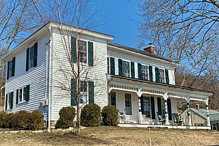
Imlaystown is an unincorporated community located along County Route 43 and Davis Station Road within Upper Freehold Township in Monmouth County, New Jersey. It is located in ZIP code 08526. The community is accessible from Exit 11 of Interstate 195.
Prallsville is an unincorporated community located along New Jersey Route 29 by the border of Stockton and Delaware Township in Hunterdon County, New Jersey. The Delaware River and Wickecheoke Creek border the community. The Prallsville District was listed on the National Register of Historic Places in 1979.
Potterstown is an unincorporated community along the border of Clinton and Readington townships in Hunterdon County, New Jersey.

The Old Eagle Tavern is a historic building located at 431, 433 South Broad Street at the corner of Ferry Street in Trenton, Mercer County, New Jersey. The building was built in 1765 by Robert Waln. The building operated as a tavern and hotel from 1765 to 1896. It was added to the National Register of Historic Places on November 3, 1972 for its architectural, commercial, and political significance. The building is also a contributing property of the Trenton Ferry Historic District, which was listed on June 26, 2013.

Arneytown is an unincorporated community located along Province Line Road on the border of North Hanover Township in Burlington County and Upper Freehold Township in Monmouth County of New Jersey. It is two miles (3.2 km) north of Jacobstown. Province Line Road was on the boundary line between the Provinces of East Jersey and West Jersey. The area was once called Upper Freehold by 18th-century Quaker settlers. With the establishment of the first post office in 1827, it became known as Arneytown.

Little York is an unincorporated community located along the border of Alexandria and Holland townships in Hunterdon County, New Jersey, United States. Little York is located on County Route 614 3.1 miles (5.0 km) north-northeast of Milford. Little York has a post office with ZIP code 08834.

Readingsburg, also known as Stone Mill, is an unincorporated community located along the South Branch Raritan River within Clinton Township in Hunterdon County, New Jersey.
Amsterdam is an unincorporated community located within Holland Township in Hunterdon County, New Jersey. Located on the southern flank of the Musconetcong Mountain, the area was settled in the first half of the 18th century. It was later named after Amsterdam, Netherlands. The Amsterdam Historic District, encompassing the community, was listed on the state and national registers of historic places in 1995.

Headquarters is an unincorporated community located within the Amwell Valley of Delaware Township in Hunterdon County, New Jersey. The settlement is centered around the intersection of Zentek Road and County Route 604. It is about 3 miles (4.8 km) from Ringoes to the east and 1 mile (1.6 km) from Sergeantsville to the west. The Headquarters Historic District was listed on the state and national registers of historic places in 2011 and had its boundary increased in 2016.

The Kingston Mill Historic District is a 49-acre (20 ha) historic district in Kingston, New Jersey. It is roughly bounded by Herrontown, River, and Princeton-Kingston Roads in the townships of Princeton in Mercer County, South Brunswick in Middlesex County, and Franklin in Somerset County. It was added to the National Register of Historic Places on April 10, 1986 for its significance in engineering, exploration/settlement, industry, and transportation. The district includes 16 contributing buildings and 2 contributing structures.

The Whitehouse–Mechanicsville Historic District is a historic district located along old New Jersey Route 28, Mill, Lamington and School Roads in Whitehouse and Mechanicsville, unincorporated communities in Readington Township, Hunterdon County, New Jersey. It was added to the National Register of Historic Places on March 17, 2015 for its significance in architecture and community development. The district includes 140 contributing buildings.

Middle Valley is an unincorporated community located along Middle Valley Road and County Route 513 in Washington Township, Morris County, New Jersey. It is near Long Valley in the valley of the South Branch Raritan River. The Middle Valley Historic District was listed on the state and national registers of historic places in 1989 and 1990.

Pleasant Valley is an unincorporated community located in Washington Township, Warren County, New Jersey, west of Washington, along the Pohatcong Creek. The hamlet was built around a mill on the creek during the mid-18th century. The Pleasant Valley Historic District, encompassing the village, is listed on the state and national registers of historic places.

Point Breeze was an estate in Bordentown, New Jersey. It was the home of Joseph Bonaparte, the brother of Napoleon Bonaparte, from 1816 to 1839.
Middletown Village is an unincorporated community located in the central part of Middletown Township, Monmouth County, New Jersey. It was the first settlement in the township and one of the oldest in New Jersey. The Middletown Village Historic District, encompassing the community, was listed on the state and national registers of historic places in 1974.

Old Bridge, also known as the Historic Village of Old Bridge, is an unincorporated community located within East Brunswick in Middlesex County, New Jersey. It is on the South River, a tributary of the Raritan River. The community is named after the first bridge built here to cross the river, the South River Bridge. After other bridges were built crossing the river, it became known as the Old Bridge. The Old Bridge Historic District, encompassing much of the village, is listed on the state and national registers of historic places.
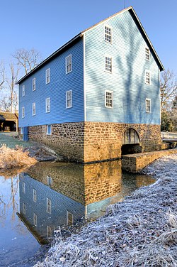
Salter's Mill is a historic gristmill built c. 1897 and located at 33 Imlaystown Road in the Imlaystown section of Upper Freehold Township in Monmouth County, New Jersey. It was added to the National Register of Historic Places on September 29, 1980, for its significance in agriculture, architecture, and exploration/settlement. The mill is next to a 28-acre (11 ha) mill pond, which was also used in the ice business. In 1985, it was also listed as a contributing property of the Imlaystown Historic District.

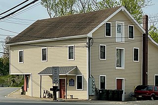
Franklin Corners is an unincorporated community located along the Passaic River at the intersection of County Route 613 and U.S. Route 202 in Bernards Township of Somerset County, New Jersey. In the 19th century, it had a grist mill, saw mill, general store, school, and several houses. The Franklin Corners Historic District, featuring Van Dorn's Mill, was listed on the National Register of Historic Places in 1975.