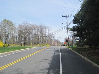
Route 18 is a 42.8-mile-long (68.9 km) state highway in the central part of the US state of New Jersey. It begins at an intersection with Route 138 in Wall Township, Monmouth County and ends at Interstate 287 (I-287) in Piscataway Township, Middlesex County. Route 18 is a major route through central New Jersey that connects the Jersey Shore to the Raritan Valley region, connecting the county seats of Monmouth (Freehold) and Middlesex respectively. The route runs through Ocean Township, Marlboro Township, and East Brunswick, as for much of the route is a limited-access freeway. The remainder of the route is a multi-lane divided highway with traffic lights in the East Brunswick and Old Bridge areas. Route 18 was designated in 1939 as a proposed freeway from Old Bridge to Eatontown. The section west of Old Bridge was formerly designated as part Route S28, a prefixed spur of State Highway Route 28 from Middlesex to Matawan. The designation, assigned in the 1927 renumbering, remained until a second renumbering in 1953. At that point, Route S28 was redesignated as Route 18, though the section from Old Bridge to Matawan was signed as TEMP 18, as this section would be decommissioned when the Route 18 freeway was built.
Route 34 is a state highway in the central part of the U.S. state of New Jersey. The route runs 26.79 mi (43.11 km) from an intersection with Route 35 and Route 70 in Wall Township, Monmouth County north to an intersection with U.S. Route 9 in Old Bridge Township, Middlesex County. The route is a four-lane divided highway between its southern terminus and the north end of the Route 33 concurrency in Howell Township; along this stretch, the route intersects the Garden State Parkway and Interstate 195 (I-195)/Route 138 within a short distance of each other. North of Route 33, Route 34 is an undivided two- to four-lane road that intersects Route 18 in Colts Neck Township and Route 79 in Matawan. Route 34 passes through mostly suburban areas along its route.

Colts Neck Township is a township in Monmouth County, New Jersey, United States. It is located in the New York Metropolitan Area. As of the 2010 United States Census, the population was 10,142, reflecting a decline of 2,189 (-17.8%) from the 12,331 counted in the 2000 Census, which had in turn increased by 3,772 (+44.1%) from the 8,559 counted in the 1990 Census.

Marlboro Township is a township in Monmouth County, New Jersey, United States. The township is located within the Raritan Valley region and is a part of the New York Metropolitan Area. As of the 2010 United States Census, the township had a population of 40,191, reflecting an increase of 5,449 (+16.3%) from the 33,423 counted in the 2000 Census, which had in turn increased by 6,707 (+25.1%) from the 26,716 counted in the 1990 Census.

Route 79 is a state highway located in Monmouth County in the U.S. state of New Jersey. It runs 12.13 mi (19.52 km) from an intersection with U.S. Route 9 in Freehold Township north to an intersection with Route 34 and County Route 516 Spur in Matawan. The route is a mostly two-lane undivided road that passes through both suburban residential, urban commercial, and open rural areas. The route intersects Route 33 in Freehold Township, Route 33 Business and CR 537 in Freehold Borough, Route 18 and CR 520 in Marlboro Township, and CR 516 in Matawan.
The Freehold Regional High School District is a public regional school district established in 1953, that serves students in ninth through twelfth grades from eight communities in western Monmouth County, New Jersey, United States. The district, with six high schools, is the largest regional high school district in the state, as measured by enrollment. The district serves students from Colts Neck Township, Englishtown, Farmingdale, Freehold Borough, Freehold Township, Howell Township, Manalapan Township and Marlboro Township.

Colts Neck High School is a four-year comprehensive public high school located in Colts Neck Township, in Monmouth County, New Jersey, United States, serving students in ninth through twelfth grades and operating as one of the six secondary schools of the Freehold Regional High School District. The school is located at the corner of County Route 537 and Five Points Road. The school serves students from all of Colts Neck Township and from portions of both Howell Township and Marlboro Township. The school has been accredited by the Middle States Association of Colleges and Schools Commission on Elementary and Secondary Schools since 2008.
The Marlboro Township School District is a community public school district that serves students in pre-kindergarten through eighth grade in Marlboro Township in Monmouth County, New Jersey, United States.
County Route 537 is a county highway in the U.S. state of New Jersey. The highway extends 66.22 miles (106.57 km) from Delaware Avenue in Camden to CR 11 in Oceanport. It is the state's fourth longest 500 series county route.
The Colts Neck School District is a comprehensive community public school district serving students in pre-kindergarten through eighth grade in Colts Neck Township in Monmouth County, New Jersey, United States.
U.S. Route 9 is a U.S. highway in the northeast United States, running from Laurel, Delaware north to Champlain, New York. In New Jersey, it runs from Cape May to Fort Lee northwards.

Adelphia is an unincorporated community located within the northern section of Howell Township in Monmouth County, New Jersey, United States. The area is served as United States Postal Service ZIP code 07710. The community borders Freehold Township.
County Route 520 is a county highway in the U.S. state of New Jersey. County Route 520 is a major road across Monmouth County connecting the county's central towns to the Jersey Shore at Sea Bright. The highway extends 22.39 miles (36.03 km) from Englishtown Road in Old Bridge Township to Ocean Avenue in Sea Bright.

Chairville is a rural unincorporated community located along the border of Medford and Southampton townships in Burlington County, New Jersey, United States. The settlement is named for a chair parts factory that operated from 1845 to 1890. Also located in the area were the Peacock Cemetery, a sawmill, and a one-room schoolhouse. Today, the site is located at the intersection of Chairville Road and New Jersey Route 70 and Little Creek.
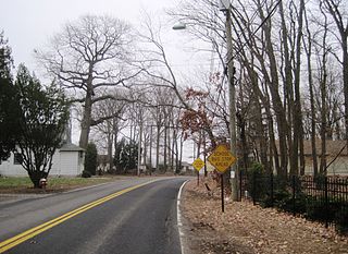
Montrose is an unincorporated community located near the intersection of Dutch Lane Road and Boundary Road along the border of Colts Neck and Marlboro townships in Monmouth County, New Jersey, United States. The town was located in "Atlantic Township" at one time prior to the name being changed to "Colts Neck". Prior to being called Montrose, the area was called "Barrentown".
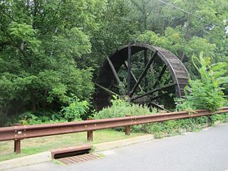
Bucks Mill is an unincorporated community located within Colts Neck Township, in Monmouth County, New Jersey, United States. Bucks Mill Road is the main road that passes north and south through the area; County Route 537 travels to the south of Bucks Mill, near the Hominy Hill Golf Course. Homes, equestrian facility and horse farms, and the township-owned Bucks Mill Recreational Area are located in the area. The settlement is named for Bucks Mill, a gristmill that derived its power from a watermill on the Yellow Brook. Originally built in 1854 and owned for many years by William Buck, Alfred Buck, and Garrett Buck, it was destroyed by a fire on October 30, 1967. The watermill is the only remaining artifact of the original complex and stands today on the side of Bucks Mill Road.

Penns Neck is an unincorporated community located within West Windsor Township in Mercer County, New Jersey, United States. The community developed at the intersection of the Trenton-New Brunswick Turnpike and Washington Road. The Penns Neck Circle and the historic Penns Neck Baptist Church (1812) are both located in Penns Neck. The Princeton Branch rail line, known as the Dinky, has run through the area since 1865, and stopped at Penns Neck station until January 1971.

New Canton is an unincorporated community located along the border of Robbinsville Township in Mercer County and Upper Freehold Township in Monmouth County, New Jersey, United States. The area was once known as Cabbagetown and has been settled since the 18th century. The settlement is located at the intersection of Old York Road and New Canton-Stone Tavern Road just north of Interstate 195's interchange 8. The Upper Freehold side of the area contains farmland and new housing developments while the Robbinsville side features new commercial warehouse buildings including an Amazon.com Fulfillment Center opened in July 2014.
Sand Hills is an unincorporated community located within South Brunswick Township in Middlesex County, New Jersey, United States. The settlement is named for Sand Hills, a small group of diabase hills which contains Middlesex County's highest point. The settlement is located approximately at the intersection of U.S. Route 1, Sand Hills Road, and Major Road. There is a small cluster of houses and small businesses on Major Road just south of US 1 while more housing developments are found on the north side of the highway. Fast food restaurants, stores, and repair shops line US 1 through the area; this area of US 1 also has large inclines on both sides of the hills to climb from the relatively low and flat areas of the Atlantic coastal plain.

Burlington Heights is an unincorporated community located within Freehold Township in Monmouth County, New Jersey, United States. The community was created in the early 1960s and originally consisted of 112 homes of mixed styles designed by Peter Petillo and Associates of Freehold. It is located along Colts Neck Road on the east side of the township, near New Jersey Route 18 and the Colts Neck municipal line.


