Millstone Township is a township in western Monmouth County, in the U.S. state of New Jersey. The township is located within the Raritan Valley region and is a part of the New York metropolitan area. As of the 2020 United States census, the township's population was 10,376, a decrease of 190 (−1.8%) from the 2010 census count of 10,566, which in turn reflected an increase of 1,596 (+17.8%) from the 8,970 counted in the 2000 census.

Upper Freehold Township is a township in Monmouth County, in the U.S. state of New Jersey. As of the 2020 United States census, the township's population was 7,273, an increase of 371 (+5.4%) from the 2010 census count of 6,902, which in turn reflected an increase of 2,620 (+61.2%) from the 4,282 counted in the 2000 census.

West Freehold is an unincorporated community and census-designated place (CDP) within Freehold Township, in Monmouth County, New Jersey, United States. As of the 2010 United States Census, the CDP's population was 13,613. Due to the community's close proximity to the Battle of Monmouth, West Freehold is home to several important historical structures, which have been preserved in the 'West Freehold Village Historic District'. The historically preserved Monmouth Battlefield, along with the historic villages of Clarksburg, Englishtown, Smithburg and Tennent are a short distance away.

Adelphia is an unincorporated community located in northern Howell Township, Monmouth County, in the U.S. state of New Jersey. The area is served as United States Postal Service ZIP code 07710. The community borders Freehold Township, and residents who reside in Adelphia use a Freehold mailing address.

Perrineville is an unincorporated community located within Millstone Township in Monmouth County, in the U.S. state of New Jersey. The area is served as United States Postal Service ZIP Code 08535.

Holmeson is an unincorporated community located within Millstone Township in Monmouth County, in the U.S. state of New Jersey. As it is located along County Route 537 through which the Monmouth–Ocean county line runs down the center, portions of the community are also located in Jackson Township. Owing to its location near Interstate 195 and Six Flags Great Adventure, the community is mostly made up of gas stations, restaurants, and small businesses though the Jackson Premium Outlets occupies land just south of the community.

Smithburg is an unincorporated community located where the municipal boundaries of Freehold, Manalapan and Millstone townships intersect in Monmouth County, in the U.S. state of New Jersey. County Route 527 and Monmouth Road pass through the center of the quaint village of Smithburg.

Prospertown is an unincorporated community located within the New Jersey townships of Jackson and Plumsted in Ocean County and Upper Freehold in Monmouth County. The community is home to Prospertown Lake and is adjacent to Six Flags Great Adventure, both located on County Route 537. The center of the community is located at the intersection of CR 537, Hawkin Road, and Emleys Hill Road. Most of the area consists of pine forests but there are some homes along the roads in the area.
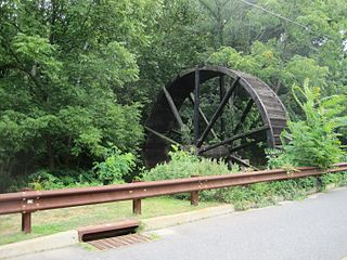
Bucks Mill is an unincorporated community located within Colts Neck Township, in Monmouth County, in the U.S. state of New Jersey. Bucks Mill Road is the main road that passes north and south through the area; County Route 537 travels to the south of Bucks Mill, near the Hominy Hill Golf Course. Homes, equestrian facility and horse farms, and the township-owned Bucks Mill Recreational Area are located in the area. The settlement is named for Bucks Mill, a gristmill that derived its power from a watermill on the Yellow Brook. Originally built in 1854 and owned for many years by William Buck, Alfred Buck, and Garrett Buck, it was destroyed by a fire on October 30, 1967. The watermill is the only remaining artifact of the original complex and stands today on the side of Bucks Mill Road.

Emleys Hill is an unincorporated community located within Upper Freehold Township in Monmouth County, in the U.S. state of New Jersey. The settlement is located at the intersection of Emleys Hill Road and Burlington Path Road.

Wyckoffs Mills is an unincorporated community located along the border of Cranbury and Monroe townships in Middlesex County, in the U.S. state of New Jersey. Located at the intersection of Wyckoff Mills Road and Wyckoffs Mills Road, the area only contains lots containing residential structures; the remainder of the land is made up of farmland and wetlands. The Millstone River flows to the south of the settlement and a 500-kilovolt transmission line crosses the farmland to the north and south.

Bergerville is an unincorporated community located within Howell Township in Monmouth County, in the U.S. state of New Jersey. The area was originally developed as a resort bungalow community in the first half of the 20th century.

Charleston Springs is an unincorporated community located within Millstone Township in Monmouth County, in the U.S. state of New Jersey. Stage Coach Road, also designated County Route 524, is the main road that runs through the settlement, with Ely Harmony Road as the intersecting road defining the locality. The Manalapan Brook runs to the west of the center of Charleston Springs and CR 537 runs to the south of the area. The Monmouth County-owned Charleston Springs Golf Course is located one mile (1.6 km) northeast of the center of Charleston Springs on CR 527.

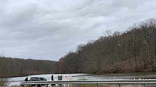
Cooleys Corner is an unincorporated community located within Upper Freehold Township in Monmouth County, in the U.S. state of New Jersey. The site of the settlement is within the Assunpink Wildlife Management Area, a New Jersey Department of Environmental Protection Division of Fish and Wildlife-operated preserved area in Monmouth and Mercer counties along the Assunpink Creek. Before the creation of the Assunpink Lake in the 1970s, the area consisted of farmland located at the intersection of Clarksburg Road and Imlaystown-Hightstown Road. Some farmland is still present in the area but is now mostly used by hunters. The main boat ramp to Assunpink Lake is located along the former Imlaystown-Hightstown Road.
Glendola is an unincorporated community located within Wall Township in Monmouth County, in the U.S. state of New Jersey. It is the location of the Glendola Reservoir. Most of the area consists of single-family residences along numerous streets throughout the settlement. The main east–west road through Glendola is Belmar Boulevard while access to the nearby Route 18 freeway is provided via Brighton Avenue.

Red Valley is an unincorporated community located within Upper Freehold Township in Monmouth County, in the U.S. state of New Jersey. The settlement is located at the intersection of County Route 526 and Red Valley Road (south) and Yellow Meetinghouse Road (north) near the township's eastern border with Millstone Township. Except for some single-family houses located along the roads in the area, the area is primarily made up of farmland.

Old Church is an unincorporated community located within Monroe Township in Middlesex County, in the U.S. state of New Jersey. The settlement is named for a Presbyterian community that settled on the site but relocated to Cranbury c. 1740. Originally, the area was farmland. One of the farms in the area was the Dey Farm, in existence since the founding of Monroe Township in 1838 and the site of a command post used by George Washington during the Battle of Monmouth in 1778. Starting in 2004, the area experienced a major change from its agricultural roots to single-family residences on the south side of the area and age-restricted communities to the north. This redevelopment also caused the severing of the main north–south road, Old Church Road and the extension of Federal Road which formerly had its western end at Old Church Road to Applegarth Road. The a farmhouse named England House was moved 4,000 feet (1,200 m) to the Dey Farm site to preserve the area's history prior to the construction of the new houses in 2004.

Sharon is an unincorporated community located within Upper Freehold Township in Monmouth County, in the U.S. state of New Jersey. Located at the intersection of Herbert Road and Sharon Station Road, the settlement is the site of a former stop on the Pemberton and Hightstown Railroad. Except for a few single-family homes in the area, most of the area is farmland. The railroad has since been abandoned and is being converted to the Union Transportation Trail, a rail trail. Sharon is the current northern terminus of the trail.

Stone Tavern is an unincorporated community located on the border of Millstone and Upper Freehold townships in Monmouth County, in the U.S. state of New Jersey.

West Farms is an unincorporated community located within Howell Township in Monmouth County, in the U.S. state of New Jersey. The settlement is centered on the intersection of West Farms Road and Casino Drive, located to the west of Farmingdale and to the north of the Manasquan Reservoir. It was once home Jewish farmers who settled there in the early 20th century. The rural area is mostly made up of wooded areas with some houses and churches dotted along the two aforementioned roads. Numerous small farms are also located throughout the area.


