Millstone Township is a township in western Monmouth County, in the U.S. state of New Jersey. The township is located within the Raritan Valley region and is a part of the New York metropolitan area. As of the 2020 United States census, the township's population was 10,376, a decrease of 190 (−1.8%) from the 2010 census count of 10,566, which in turn reflected an increase of 1,596 (+17.8%) from the 8,970 counted in the 2000 census.

Upper Freehold Township is a township in Monmouth County, in the U.S. state of New Jersey. As of the 2020 United States census, the township's population was 7,273, an increase of 371 (+5.4%) from the 2010 census count of 6,902, which in turn reflected an increase of 2,620 (+61.2%) from the 4,282 counted in the 2000 census.
Franklin Township is a township in Somerset County, in the U.S. state of New Jersey. It is centrally located in the Raritan Valley region, within the New York Metropolitan Area. As of the 2020 United States census, the township's population was 68,364, an increase of 6,064 (+9.7%) from the 2010 census count of 62,300, which in turn reflected an increase of 11,397 (+22.4%) from the 50,903 counted in the 2000 census. The township was the state's 19th most-populous municipality in 2020, after being ranked 22nd in 2010.

Millstone is a borough in Somerset County, in the U.S. state of New Jersey. The borough was originally known as Somerset Courthouse and was the county seat. As of the 2020 United States census, the borough's population was 448, an increase of 30 (+7.2%) from the 2010 census count of 418, which in turn reflected an increase of 8 (+2.0%) from the 410 counted in the 2000 census.

Clarksburg is an unincorporated community located within Millstone Township in Monmouth County, in the U.S. state of New Jersey. The area is served as United States Postal Service ZIP code 08510.

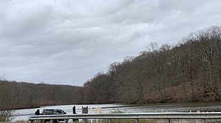
The Millstone River is a 38.6-mile-long (62.1 km) tributary of the Raritan River in central New Jersey in the United States.

Griggstown is an unincorporated community and census-designated place (CDP) located within Franklin Township, in Somerset County, in the U.S. state of New Jersey. As of the 2010 United States Census, the CDP's population was 819. The area was first settled around 1733. The Millstone River and the Delaware and Raritan Canal both flow through Griggstown.

East Millstone is an unincorporated community and census-designated place (CDP) located in Franklin Township in Somerset County, in the U.S. state of New Jersey.

County Route 518 is a county highway in the U.S. state of New Jersey. The highway extends 20.58 miles (33.12 km) from Route 29/Route 165 in Lambertville to Lincoln Highway in Franklin Township. It is also known as the Georgetown Franklin Turnpike.
Weston is an unincorporated community and census-designated place (CDP) located in Franklin Township, in Somerset County, in the U.S. state of New Jersey. As of the 2010 United States Census, the CDP's population was 1,235.

Perrineville is an unincorporated community located within Millstone Township in Monmouth County, in the U.S. state of New Jersey. The area is served as United States Postal Service ZIP Code 08535.

Smithburg is an unincorporated community located where the municipal boundaries of Freehold, Manalapan and Millstone townships intersect in Monmouth County, in the U.S. state of New Jersey. County Route 527 and Monmouth Road pass through the center of the quaint village of Smithburg.

Fair Play is a rural unincorporated community in Millstone Township, Monmouth County, in the U.S. state of New Jersey. It is just south of Disbrow Hill and north of Rocky Brook on County Route 1 at Fairplay Road, west of Perrineville and southeast of Hightstown.

Penns Neck is an unincorporated community located within West Windsor Township in Mercer County, in the U.S. state of New Jersey. The community developed at the intersection of the Trenton-New Brunswick Turnpike and Washington Road. The Penns Neck Circle and the historic Penns Neck Baptist Church (1812) are both located in Penns Neck. The Princeton Branch rail line, known as the Dinky, has run through the area since 1865, and stopped at Penns Neck station until January 1971.

Wyckoffs Mills is an unincorporated community located along the border of Cranbury and Monroe townships in Middlesex County, in the U.S. state of New Jersey. Located at the intersection of Wyckoff Mills Road and Wyckoffs Mills Road, the area only contains lots containing residential structures; the remainder of the land is made up of farmland and wetlands. The Millstone River flows to the south of the settlement and a 500-kilovolt transmission line crosses the farmland to the north and south.

Charleston Springs is an unincorporated community located within Millstone Township in Monmouth County, in the U.S. state of New Jersey. Stage Coach Road, also designated County Route 524, is the main road that runs through the settlement, with Ely Harmony Road as the intersecting road defining the locality. The Manalapan Brook runs to the west of the center of Charleston Springs and CR 537 runs to the south of the area. The Monmouth County-owned Charleston Springs Golf Course is located one mile (1.6 km) northeast of the center of Charleston Springs on CR 527.

Ely is an unincorporated community located within Millstone Township in Monmouth County, in the U.S. state of New Jersey. The settlement is named for the Ely family that owned property in the area and operated the Charleston Springs hotel. Today, the settlement is located along Stage Coach Road, County Route 524, in the eastern portion of the township. Most of the area consists of large single-family homes though some farmland and the township-owned Brandywine Soccer Complex are located in the near the settlement.

Red Valley is an unincorporated community located within Upper Freehold Township in Monmouth County, in the U.S. state of New Jersey. The settlement is located at the intersection of County Route 526 and Red Valley Road (south) and Yellow Meetinghouse Road (north) near the township's eastern border with Millstone Township. Except for some single-family houses located along the roads in the area, the area is primarily made up of farmland.

Stone Tavern is an unincorporated community located on the border of Millstone and Upper Freehold townships in Monmouth County, in the U.S. state of New Jersey.


