
Monmouth County is a county located in the central portion of the U.S. state of New Jersey. It is bordered to its west by Mercer and Middlesex Counties, to its south by Ocean County, to its east by the Atlantic Ocean, and to its north by the Raritan Bay. Monmouth County's geographic area comprises 30% water. The county is part of the Jersey Shore region of the state. It has also been categorized under the Central Jersey region, though it was not among the four counties explicitly listed as included in Central Jersey as part of legislation signed into law in 2023.

Route 36 is a state highway in Monmouth County, New Jersey, United States. The 24.4-mile (39.27 km) long route, shaped as a backwards C, begins at an intersection with the Garden State Parkway and Hope Road on the border of Tinton Falls and Eatontown and runs east to Long Branch. From Long Branch, the route follows the Atlantic Ocean north to Sea Bright and turns west, running to the south of the Raritan Bay. Route 36 ends in Keyport at an interchange with the Garden State Parkway and Route 35. It varies in width from a six-lane divided highway to a two-lane undivided road. The route is signed east–west between Eatontown and Long Branch and north–south between Long Branch and Keyport.

Fair Haven is a borough situated in the Jersey Shore region within Monmouth County, in the U.S. state of New Jersey, in the New York metropolitan area. Fair Haven is located on the Rumson peninsula along the Navesink River and is bordered by Red Bank and Little Silver to the west. As of the 2020 United States census, the borough's population was 6,269, its highest decennial count ever and an increase of 148 (+2.4%) from the 2010 census count of 6,121, which in turn reflected an increase of 184 (+3.1%) from the 5,937 counted in the 2000 census.

Highlands is a borough in northern Monmouth County, in the U.S. state of New Jersey. An historic waterfront community located on the Raritan Bay within the Raritan Valley region, this scenic borough is a commuter town of New York City in the New York metropolitan area. As of the 2020 United States census, the borough's population was 4,621, a decrease of 384 (−7.7%) from the 2010 census count of 5,005, which in turn reflected a decline of 92 (−1.8%) from the 5,097 counted in the 2000 census. The eastern part of the town is on a high bluff that overlooks Sandy Hook Bay, the entrance to New York Harbor, and the Atlantic Ocean, from which the borough derives its name. Atop this bluff are the Navesink Twin Lights.

Middletown Township is a township in northern Monmouth County, in the U.S. state of New Jersey. As of the 2020 United States census, the township was the state's 20th-most-populous municipality and the largest in the county, with a population of 67,106, an increase of 584 (+0.9%) from the 2010 census count of 66,522, which in turn reflected an increase of 195 residents (0.3%) from its population of 66,327 at the 2000 census, when it was the state's 17th-most-populous municipality.

Navesink is an unincorporated community and census-designated place (CDP) located on the northernmost stretch of the Jersey Shore in Middletown Township in Monmouth County, in the U.S. state of New Jersey. As of the 2020 United States census, the CDP's population was 2,004, reflecting a decrease of 16 (-0.8%) from thd 2,020 residents enumerated at the 2010 U.S. census.

Red Bank is a borough in Monmouth County, in the U.S. state of New Jersey. Incorporated in 1908, the community is on the Navesink River, the area's original transportation route to the ocean and other ports. Red Bank is in the New York metropolitan area and is a commuter town of New York City. As of the 2020 United States census, the borough's population was 12,936, an increase of 730 (+6.0%) from the 2010 census count of 12,206, which in turn reflected an increase of 362 (+3.1%) from the 11,844 counted in the 2000 census. In the 2020 census, Red Bank was the fourth-most densely populated municipality in Monmouth County.

Rumson is a borough in Monmouth County, in the U.S. state of New Jersey, and is part of the New York Metropolitan Area. As of the 2020 United States census, the borough's population was 7,343, an increase of 221 (+3.1%) from the 2010 census count of 7,122, which in turn reflected a decline of 15 (−0.2%) from 7,137 in 2000.

Shrewsbury Township is a township situated in the Jersey Shore region, within Monmouth County, in the U.S. state of New Jersey. As of the 2020 United States census, the township's population was 1,076, a decrease of 65 (−5.7%) from the 2010 census count of 1,141, which in turn reflected an increase of 43 (+3.9%) from the 1,098 counted in the 2000 census.

Sea Bright is a borough situated on the Jersey Shore, within Monmouth County, in the U.S. state of New Jersey. As of the 2020 United States census, the borough's population was 1,449, an increase of 37 (+2.6%) from the 2010 census count of 1,412, which in turn had reflected a decline of 406 (−22.3%) from the 1,818 counted in the 2000 census.

Shrewsbury is a borough in eastern Monmouth County, in the U.S. state of New Jersey. Located within the heart of the northern Shore region, the borough is a bedroom community of New York City. As of the 2020 United States census, the borough's population was 4,184, its highest decennial count ever and an increase of 375 (+9.8%) from the 2010 census count of 3,809, which in turn reflected an increase of 219 (+6.1%) from the 3,590 counted in the 2000 census.

The Navesink River is an estuary in the eastern United States in Monmouth County, New Jersey. Approximately eight miles (13 km) in length, it is surrounded by the communities of Middletown, Red Bank, Fair Haven, and Rumson.

The Shrewsbury River is a short stream and navigable estuary. The stream is approximately 8 mi long and is located in Monmouth County in Central New Jersey.

The Raritan Bayshore is a region in central sections in the state of New Jersey. It is the area around Raritan Bay from The Amboys to Sandy Hook, in Middlesex and Monmouth counties, including the towns of Perth Amboy, South Amboy, Sayreville, Old Bridge, Matawan, Aberdeen, Keyport, Union Beach, Hazlet, Keansburg, Middletown, Atlantic Highlands, and Highlands. It is the northernmost part of the Jersey Shore, located just south of New York City. At Keansburg is a traditional amusement park while at Sandy Hook are found ocean beaches. The Sadowski Parkway beach area in Perth Amboy, which lies at the mouth of the Raritan River, was deemed the "Riviera of New Jersey" by local government. In recent years many of the beaches on the Bayshore area have been rediscovered and upgraded.
The Middletown Township Public School District is a comprehensive community public school district that serves students from pre-kindergarten through twelfth grade from Middletown Township in Monmouth County, in the U.S. state of New Jersey.

County Route 520 (CR 520) is a county highway in the U.S. state of New Jersey. CR 520 is a major road across Monmouth County connecting the county's central towns to the Jersey Shore at Sea Bright. The highway extends 22.3 miles (35.9 km) from Englishtown Road (CR 527) in Old Bridge to Ocean Avenue (Route 36) in Sea Bright.

The Shark River Inlet is an inlet that connects the Atlantic Ocean with the Shark River, located entirely in Monmouth County, New Jersey, United States. The Shark River Inlet acts as a border between the towns of Belmar and Avon-by-the-Sea at the Atlantic Ocean. The Shark River Inlet is the only river inlet exclusively in Monmouth County that drains directly into the Atlantic Ocean; the Shrewsbury and Navesink rivers drain into Sandy Hook Bay, and the Manasquan River is shared with Ocean County.

The Parker Homestead is a historic home and grounds in Little Silver, Monmouth County, New Jersey, United States, located at 235 Rumson Road near Sickles Park. The main house was originally built circa 1720, and includes materials from an earlier structure the early and late 19th century, and the 1910s and 1920s. It is one of the oldest extant buildings in the state. The farmstead which also includes three outlying barns were listed on the New Jersey Register of Historic Places and the National Register of Historic Places. in 2011.

Oceanic is an unincorporated community located within Rumson in Monmouth County, in the U.S. state of New Jersey. Located on the north side of the borough, Oceanic contains most of Rumson's commercial businesses mainly along Bingham Avenue and River Road. Bingham Avenue connects directly to the Oceanic Bridge over the Navesink River to the Middletown Township community of Locust Point.
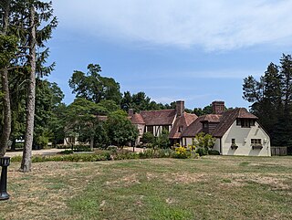
Huber Woods Park is a county park located in the community of Locust, Middletown Township, New Jersey. The 390-acre (160 ha) park, run by the Monmouth County Park System is situated in the Navesink Highlands and is primarily made up of preserved woodland and farmlands formerly owned by the Huber family. The park is often used for hiking, birdwatching and horseback riding and features an environmental center, housed in the former Huber family residence, a reptile house, and an equestrian area.


