
Route 35 is a state highway in the U.S. state of New Jersey, primarily traveling through the easternmost parts of Middlesex, Monmouth, and Ocean counties. It runs 58.1 mi (93.5 km) from the entrance to Island Beach State Park in Berkeley Township, Ocean County, to an intersection with Lincoln Highway/St. Georges Avenue (Route 27) in Rahway, Union County. Between Seaside Park and Mantoloking, Route 35 follows the right-of-way of the former Pennsylvania Railroad along the Jersey Shore. The route heads through Point Pleasant Beach and crosses the Manasquan River on the Brielle Bridge, meeting the intersection of Route 34 and Route 70 at the former Brielle Circle in Wall Township. From there, Route 35 heads north and interchanges with Route 138, an extension of I-195, continuing north through Monmouth County before crossing the Victory Bridge over the Raritan River into Perth Amboy, where the route continues north to Rahway.

Route 36 is a state highway in Monmouth County, New Jersey, United States. The 24.4-mile (39.27 km) long route, shaped as a backwards C, begins at an intersection with the Garden State Parkway and Hope Road on the border of Tinton Falls and Eatontown and runs east to Long Branch. From Long Branch, the route follows the Atlantic Ocean north to Sea Bright and turns west, running to the south of the Raritan Bay. Route 36 ends in Keyport at an interchange with the Garden State Parkway and Route 35. It varies in width from a six-lane divided highway to a two-lane undivided road. The route is signed east–west between Eatontown and Long Branch and north–south between Long Branch and Keyport.

Highlands is a borough in northern Monmouth County, in the U.S. state of New Jersey. An historic waterfront community located on the Raritan Bay within the Raritan Valley region, this scenic borough is a commuter town of New York City in the New York metropolitan area. As of the 2020 United States census, the borough's population was 4,621, a decrease of 384 (−7.7%) from the 2010 census count of 5,005, which in turn reflected a decline of 92 (−1.8%) from the 5,097 counted in the 2000 census. The eastern part of the town is on a high bluff that overlooks Sandy Hook Bay, the entrance to New York Harbor, and the Atlantic Ocean, from which the borough derives its name. Atop this bluff are the Navesink Twin Lights.

Middletown Township is a township in northern Monmouth County, in the U.S. state of New Jersey. As of the 2020 United States census, the township was the state's 20th-most-populous municipality and the largest in the county, with a population of 67,106, an increase of 584 (+0.9%) from the 2010 census count of 66,522, which in turn reflected an increase of 195 residents (0.3%) from its population of 66,327 at the 2000 census, when it was the state's 17th-most-populous municipality.

Monmouth Beach is a borough in Monmouth County, in the U.S. state of New Jersey, situated on the Jersey Shore. As of the 2020 United States census, the borough's population was 3,174, a decrease of 105 (−3.2%) from the 2010 census count of 3,279, which in turn had reflected a decline of 316 (−8.8%) from the 3,595 counted at the 2000 census.

Navesink is an unincorporated community and census-designated place (CDP) located on the northernmost stretch of the Jersey Shore in Middletown Township in Monmouth County, in the U.S. state of New Jersey. As of the 2020 United States census, the CDP's population was 2,004, reflecting a decrease of 16 (-0.8%) from thd 2,020 residents enumerated at the 2010 U.S. census.

Oceanport is a borough situated in the Jersey Shore region, within Monmouth County, in the U.S. state of New Jersey, specifically Central Jersey. As of the 2020 United States census, the borough's population was 6,150, an increase of 318 (+5.5%) from the 2010 census count of 5,832, which in turn reflected an increase of 25 (+0.4%) from the 5,807 counted in the 2000 census.

Sea Bright is a borough situated on the Jersey Shore, within Monmouth County, in the U.S. state of New Jersey. As of the 2020 United States census, the borough's population was 1,449, an increase of 37 (+2.6%) from the 2010 census count of 1,412, which in turn had reflected a decline of 406 (−22.3%) from the 1,818 counted in the 2000 census.

The Shrewsbury River is a short stream and navigable estuary. The stream is approximately 8 mi long and is located in Monmouth County in Central New Jersey.
The Navesink Twin Lights is a non-operational lighthouse and museum located in Highlands, Monmouth County, New Jersey, United States, overlooking Sandy Hook Bay, the entrance to New York Harbor, and the Atlantic Ocean. The Twin Lights, as the name implies, are a pair of beacons located 246 feet (75 m) above sea level on the headlands of the Navesink Highlands.
New Jersey's 6th congressional district is represented by Democrat Frank Pallone, who has served the district in Congress since 1993. The district includes the northern and eastern portions of Middlesex County and the coastal areas of Monmouth County, including towns along the Raritan Bay.

Red Bank is a commuter train station located in Red Bank, Monmouth County, New Jersey, United States. It is one of 20 NJ Transit commuter rail stations on the North Jersey Coast Line. It is located on Bridge Avenue between Monmouth and Oakland Streets, just south of the Navesink River, and consists of two high-level platforms on either side of grade crossings.

The Raritan Bayshore is a region in central sections in the state of New Jersey. It is the area around Raritan Bay from The Amboys to Sandy Hook, in Middlesex and Monmouth counties, including the towns of Perth Amboy, South Amboy, Sayreville, Old Bridge, Matawan, Aberdeen, Keyport, Union Beach, Hazlet, Keansburg, Middletown, Atlantic Highlands, and Highlands. It is the northernmost part of the Jersey Shore, located just south of New York City. At Keansburg is a traditional amusement park while at Sandy Hook are found ocean beaches. The Sadowski Parkway beach area in Perth Amboy, which lies at the mouth of the Raritan River, was deemed the "Riviera of New Jersey" by local government. In recent years many of the beaches on the Bayshore area have been rediscovered and upgraded.

Locust is an unincorporated community located within Middletown Township in Monmouth County, in the U.S. state of New Jersey. It is situated along the north banks of the Navesink River and Claypit Creek. The area consists of mostly medium-to-large sized houses throughout the hilly terrain of this part of the township. The Oceanic Bridge connects Locust with Rumson to the south.

Galilee is an unincorporated community located within Monmouth Beach in Monmouth County, in the U.S. state of New Jersey. The area is named for the Biblical city of Galilee and was founded as a fishing village. Located at the northern extent of Monmouth Beach, it is located along the peninsula where it begins to greatly narrow between the Shrewsbury River and the Atlantic Ocean. Single family homes typically make up the ocean side of the peninsula while condominiums and a marina are located on the river side. The Sea Bright–Monmouth Beach Seawall passes through the community and continues to neighboring Sea Bright.

Normandie is an unincorporated community located within Sea Bright in Monmouth County, in the U.S. state of New Jersey. The community is one of the four main built-up areas of Sea Bright and is a former stop on the New Jersey Southern Railroad. It is located along Route 36 between the CR 520 drawbridge to Rumson and Sandy Hook on a narrow strip of land between the Shrewsbury River and the Atlantic Ocean. The Sea Bright–Monmouth Beach Seawall passes through the neighborhood and Navesink Beach.

Oceanic is an unincorporated community located within Rumson in Monmouth County, in the U.S. state of New Jersey. Located on the north side of the borough, Oceanic contains most of Rumson's commercial businesses mainly along Bingham Avenue and River Road. Bingham Avenue connects directly to the Oceanic Bridge over the Navesink River to the Middletown Township community of Locust Point.

Sharon is an unincorporated community located within Upper Freehold Township in Monmouth County, in the U.S. state of New Jersey. Located at the intersection of Herbert Road and Sharon Station Road, the settlement is the site of a former stop on the Pemberton and Hightstown Railroad. Except for a few single-family homes in the area, most of the area is farmland. The railroad has since been abandoned and is being converted to the Union Transportation Trail, a rail trail. Sharon is the current northern terminus of the trail.
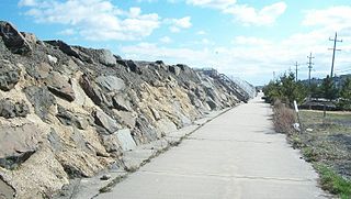
The Sea Bright–Monmouth Beach Seawall is a seawall located along the Jersey Shore in the Monmouth County, New Jersey towns of Sea Bright and Monmouth Beach. It roughly runs north-south direction along 4.7 miles (7.6 km) of the barrier spit of land along the lower Sandy Hook peninsula between the Atlantic Ocean and the Shrewsbury River estuary. The use of seawalls, groins, jetties, bulkheads, revetment, and beach nourishment since the late 1800s has made the stretch of coast one of the most heavily engineered sections of ocean shorefront in the world.
Wardell's Beach is the historic name of a barrier spit located on the Jersey Shore of the Atlantic Ocean in Monmouth County, New Jersey, United States. It takes its name from Eliakim Wardell, an early owner, and his descendants. Since the 19th century it has been joined physically to Sandy Hook, and contains the boroughs of Monmouth Beach and Sea Bright.


