
Monmouth County is a county located in the central portion of the U.S. state of New Jersey. It is bordered to its west by Mercer and Middlesex Counties, to its south by Ocean County, to its east by the Atlantic Ocean, and to its north by the Raritan Bay. Monmouth County's geographic area comprises 30% water. The county is part of the Jersey Shore region of the state. It has also been categorized under the Central Jersey region, though it was not among the four counties explicitly listed as included in Central Jersey as part of legislation signed into law in 2023.

Route 36 is a state highway in Monmouth County, New Jersey, United States. The 24.4-mile (39.27 km) long route, shaped as a backwards C, begins at an intersection of the Garden State Parkway and Hope Road on the border of Tinton Falls and Eatontown and runs east to Long Branch. From Long Branch, the route follows the Atlantic Ocean north to Sea Bright and turns west, running to the south of the Raritan Bay. Route 36 ends in Keyport at an interchange with the Garden State Parkway and Route 35. It varies in width from a six-lane divided highway to a two-lane undivided road. The route is signed east–west between Eatontown and Long Branch and north–south between Long Branch and Keyport.

Monmouth Beach is a borough in Monmouth County, in the U.S. state of New Jersey, situated on the Jersey Shore. As of the 2020 United States census, the borough's population was 3,174, a decrease of 105 (−3.2%) from the 2010 census count of 3,279, which in turn had reflected a decline of 316 (−8.8%) from the 3,595 counted at the 2000 census.

Sea Bright is a borough situated on the Jersey Shore, within Monmouth County, in the U.S. state of New Jersey. As of the 2020 United States census, the borough's population was 1,449, an increase of 37 (+2.6%) from the 2010 census count of 1,412, which in turn had reflected a decline of 406 (−22.3%) from the 1,818 counted in the 2000 census.

Sandy Hook is a barrier spit in Middletown Township, Monmouth County, New Jersey, United States. The barrier spit, approximately 6 miles (9.7 km) in length and varying from 0.1 to 1.0 mile wide, is located at the north end of the Jersey Shore. It encloses the southern entrance of Lower New York Bay south of New York City, protecting it from the open waters of the Atlantic Ocean to the east.

The Jersey Shore, commonly referred to locally as simply the Shore, is the coastal region of the U.S. state of New Jersey. Geographically, the term encompasses about 141 miles (227 km) of oceanfront bordering the Atlantic Ocean, from Perth Amboy in the north to Cape May Point in the south. The region includes Middlesex, Monmouth, Ocean, Atlantic, and Cape May counties, which are in the central and southern parts of the state. Located in the center of the Northeast Megalopolis, the northern half of the shore region is part of the New York metropolitan area, while the southern half of the shore region is part of the Philadelphia metropolitan area, also known as the Delaware Valley. The Jersey Shore hosts the highest concentration of oceanside boardwalks in the United States.

The Shrewsbury River is a short stream and navigable estuary. The stream is approximately 8 mi long and is located in Monmouth County in Central New Jersey.

The Raritan Bayshore is a region in central sections in the state of New Jersey. It is the area around Raritan Bay from The Amboys to Sandy Hook, in Middlesex and Monmouth counties, including the towns of Perth Amboy, South Amboy, Sayreville, Old Bridge, Matawan, Aberdeen, Keyport, Union Beach, Hazlet, Keansburg, Middletown, Atlantic Highlands, and Highlands. It is the northernmost part of the Jersey Shore, located just south of New York City. At Keansburg is a traditional amusement park while at Sandy Hook are found ocean beaches. The Sadowski Parkway beach area in Perth Amboy, which lies at the mouth of the Raritan River, was deemed the "Riviera of New Jersey" by local government. In recent years many of the beaches on the Bayshore area have been rediscovered and upgraded.
Port-au-peck is an unincorporated community located within Oceanport in Monmouth County, in the U.S. state of New Jersey. The name Port-Au-Peck comes from the Lenape name Pootapeck. The land was "sold" to English interests in 1670; however, it is unclear how fair this land transfer was or if the local residents were aware they were giving away their hunting and fishing rights in the transfer.

Locust is an unincorporated community located within Middletown Township in Monmouth County, in the U.S. state of New Jersey. It is situated along the north banks of the Navesink River and Claypit Creek. The area consists of mostly medium-to-large sized houses throughout the hilly terrain of this part of the township. The Oceanic Bridge connects Locust with Rumson to the south.

Holmeson is an unincorporated community located within Millstone Township in Monmouth County, in the U.S. state of New Jersey. As it is located along County Route 537 through which the Monmouth–Ocean county line runs down the center, portions of the community are also located in Jackson Township. Owing to its location near Interstate 195 and Six Flags Great Adventure, the community is mostly made up of gas stations, restaurants, and small businesses though the Jackson Premium Outlets occupies land just south of the community.

Prospertown is an unincorporated community located within the New Jersey townships of Jackson and Plumsted in Ocean County and Upper Freehold in Monmouth County. The community is home to Prospertown Lake and is adjacent to Six Flags Great Adventure, both located on County Route 537. The center of the community is located at the intersection of CR 537, Hawkin Road, and Emleys Hill Road. Most of the area consists of pine forests but there are some homes along the roads in the area.

Freewood Acres is an unincorporated community located within Howell Township in Monmouth County, in the U.S. state of New Jersey. The area is made up of mostly single-story homes arranged along a street grid in the northern reaches of the Pine Barrens. U.S. Route 9 runs through the center of the community just north of its interchange with Interstate 195. The Land O'Pines Elementary School and Manasquan Reservoir County Park exist to the east of the community. It became the center of the Kalmyk American community in the latter part of the 20th century.

Navesink Beach is an unincorporated community located within Sea Bright in Monmouth County, in the U.S. state of New Jersey. It is one of the four main built-up areas of Sea Bright and is the northernmost settled area of the borough. Navesink Beach is a former stop on the New Jersey Southern Railroad. The Sea Bright–Monmouth Beach Seawall passes through the neighborhood and Normandie.

Normandie is an unincorporated community located within Sea Bright in Monmouth County, in the U.S. state of New Jersey. The community is one of the four main built-up areas of Sea Bright and is a former stop on the New Jersey Southern Railroad. It is located along Route 36 between the CR 520 drawbridge to Rumson and Sandy Hook on a narrow strip of land between the Shrewsbury River and the Atlantic Ocean. The Sea Bright–Monmouth Beach Seawall passes through the neighborhood and Navesink Beach.

Oceanic is an unincorporated community located within Rumson in Monmouth County, in the U.S. state of New Jersey. Located on the north side of the borough, Oceanic contains most of Rumson's commercial businesses mainly along Bingham Avenue and River Road. Bingham Avenue connects directly to the Oceanic Bridge over the Navesink River to the Middletown Township community of Locust Point.
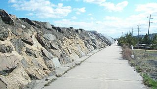
The Sea Bright–Monmouth Beach Seawall is a seawall located along the Jersey Shore in the Monmouth County, New Jersey towns of Sea Bright and Monmouth Beach. It roughly runs north-south direction along 4.7 miles (7.6 km) of the barrier spit of land along the lower Sandy Hook peninsula between the Atlantic Ocean and the Shrewsbury River estuary. The use of seawalls, groins, jetties, bulkheads, revetment, and beach nourishment since the late 1800s has made the stretch of coast one of the most heavily engineered sections of ocean shorefront in the world.
Wardell's Beach is the historic name of a barrier spit located on the Jersey Shore of the Atlantic Ocean in Monmouth County, New Jersey, United States. It takes its name from Eliakim Wardell, an early owner, and his descendants. Since the 19th century it has been joined physically to Sandy Hook, and contains the boroughs of Monmouth Beach and Sea Bright.
Squan Beach is the historic name of a barrier spit located on the Jersey Shore of the Atlantic Ocean in Ocean County, New Jersey, United States. Since the closing of Cranberry Inlet around 1812, it has been joined physically to Island Beach, and is a major component of the Barnegat Peninsula.
Cranberry Inlet was an inlet connecting Barnegat Bay with the Atlantic Ocean in Ocean County, New Jersey. It has been closed since 1812.


