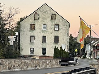
Allentown is a borough located in western Monmouth County, in the U.S. state of New Jersey, bordering adjacent Mercer County. As of the 2020 United States census, the borough's population was 1,734, a decrease of 94 (−5.1%) from the 2010 census count of 1,828, which in turn reflected a decline of 54 (−2.9%) from the 1,882 counted in the 2000 census. The borough is nestled within central New Jersey, and is roughly equidistant between New York City and Philadelphia.

Freehold Township is a township in western Monmouth County, in the U.S. state of New Jersey. Crisscrossed by several major highways, the township is a commercial hub for Central New Jersey and is a suburban bedroom community of New York City, located within the Raritan Valley region of the much larger New York Metropolitan Area. The township is located roughly 38 miles (61 km) away from Manhattan and about 20 miles (32 km) away from Staten Island. As of the 2020 United States census, the township's population was 35,369, a decrease of 815 (−2.3%) from the 36,184 recorded at the 2010 census, which in turn reflected an increase of 4,647 (+14.7%) from the 31,537 counted in the 2000 census.
Millstone Township is a township in western Monmouth County, in the U.S. state of New Jersey. The township is located within the Raritan Valley region and is a part of the New York metropolitan area. As of the 2020 United States census, the township's population was 10,376, a decrease of 190 (−1.8%) from the 2010 census count of 10,566, which in turn reflected an increase of 1,596 (+17.8%) from the 8,970 counted in the 2000 census.

Upper Freehold Township is a township in Monmouth County, in the U.S. state of New Jersey. As of the 2020 United States census, the township's population was 7,273, an increase of 371 (+5.4%) from the 2010 census count of 6,902, which in turn reflected an increase of 2,620 (+61.2%) from the 4,282 counted in the 2000 census.

West Freehold is an unincorporated community and census-designated place (CDP) within Freehold Township, in Monmouth County, New Jersey, United States. As of the 2010 United States Census, the CDP's population was 13,613. Due to the community's close proximity to the Battle of Monmouth, West Freehold is home to several important historical structures, which have been preserved in the 'West Freehold Village Historic District'. The historically preserved Monmouth Battlefield, along with the historic villages of Clarksburg, Englishtown, Smithburg and Tennent are a short distance away.

Clarksburg is an unincorporated community located within Millstone Township in Monmouth County, in the U.S. state of New Jersey. The area is served as United States Postal Service ZIP code 08510.
The Upper Freehold Regional School District is a regional public school district in Monmouth County, in the U.S. state of New Jersey, which provides educational services to students in pre-kindergarten through twelfth grade from Allentown Borough and Upper Freehold Township. Millstone Township sends students to the district's high school as part of a sending/receiving relationship with the Millstone Township Schools.

County Route 539 is a county highway in the U.S. state of New Jersey. The highway extends 54.32 miles (87.42 km) from Main Street in Tuckerton to CR 535 in Cranbury Township. Much of the two-lane route passes through isolated areas of the Pine Barrens and the eastern end of the Fort Dix entity of Joint Base McGuire–Dix–Lakehurst. In these stretches, the route has a speed limit of 55 miles per hour (89 km/h), one of the few two-lane roads in the state to carry a 55 mph limit. CR 539 passes through three boroughs: Tuckerton, Allentown, and Hightstown. Other than those boroughs, the route travels mainly through rural townships.

Adelphia is an unincorporated community located in northern Howell Township, Monmouth County, in the U.S. state of New Jersey. The area is served as United States Postal Service ZIP code 07710. The community borders Freehold Township, and residents who reside in Adelphia use a Freehold mailing address.

County Route 524 is a county highway in the U.S. state of New Jersey. The highway extends 39.90 miles (64.21 km) from the White Horse Circle in Hamilton Township to Route 71 in Spring Lake Heights.
The Millstone Township Schools are a community public school district that serves students in pre-kindergarten through eighth grade from Millstone Township, in Monmouth County, in the U.S. state of New Jersey.

Smithburg is an unincorporated community located where the municipal boundaries of Freehold, Manalapan and Millstone townships intersect in Monmouth County, in the U.S. state of New Jersey. County Route 527 and Monmouth Road pass through the center of the quaint village of Smithburg.

Arneytown is an unincorporated community located along Province Line Road on the border of North Hanover Township in Burlington County and Upper Freehold Township in Monmouth County of New Jersey. It is two miles (3.2 km) north of Jacobstown. Province Line Road was on the boundary line between the Provinces of East Jersey and West Jersey. The area was once called Upper Freehold by 18th-century Quaker settlers. With the establishment of the first post office in 1827, it became known as Arneytown.

Prospertown is an unincorporated community located within the New Jersey townships of Jackson and Plumsted in Ocean County and Upper Freehold in Monmouth County. The community is home to Prospertown Lake and is adjacent to Six Flags Great Adventure, both located on County Route 537. The center of the community is located at the intersection of CR 537, Hawkin Road, and Emleys Hill Road. Most of the area consists of pine forests but there are some homes along the roads in the area.

New Canton is an unincorporated community located along the border of Robbinsville Township in Mercer County and Upper Freehold Township in Monmouth County, in the U.S. state of New Jersey. The area was once known as Cabbagetown and has been settled since the 18th century. The settlement is located at the intersection of Old York Road and New Canton-Stone Tavern Road just north of Interstate 195's interchange 8. The Upper Freehold side of the area contains farmland and new housing developments while the Robbinsville side features new commercial warehouse buildings including an Amazon.com Fulfillment Center opened in July 2014.

Emleys Hill is an unincorporated community located within Upper Freehold Township in Monmouth County, in the U.S. state of New Jersey. The settlement is located at the intersection of Emleys Hill Road and Burlington Path Road.

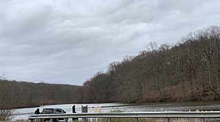
Ely is an unincorporated community located within Millstone Township in Monmouth County, in the U.S. state of New Jersey. The settlement is named for the Ely family that owned property in the area and operated the Charleston Springs hotel. Today, the settlement is located along Stage Coach Road, County Route 524, in the eastern portion of the township. Most of the area consists of large single-family homes though some farmland and the township-owned Brandywine Soccer Complex are located in the near the settlement.

Fairfield is an unincorporated community located within Howell Township in Monmouth County, in the U.S. state of New Jersey. The community is centered on the intersection of County Route 524 (CR 524) and Ketchum Road, where the Colonial Era Our House Tavern is located. The area includes several small businesses, township offices and schools. There are also small farms and residential developments in the area. Fairfield was a stop on the Freehold and Jamesburg Agricultural Railroad.

Red Valley is an unincorporated community located within Upper Freehold Township in Monmouth County, in the U.S. state of New Jersey. The settlement is located at the intersection of County Route 526 and Red Valley Road (south) and Yellow Meetinghouse Road (north) near the township's eastern border with Millstone Township. Except for some single-family houses located along the roads in the area, the area is primarily made up of farmland.

Coxs Corner, also known as Cox's Corner or Wrightsville, is an unincorporated community located within Upper Freehold Township, in Monmouth County, in the U.S. state of New Jersey. Named for congressman and brigadier general James Cox (1753–1810), who had lived here at the family home of "Box Grove", it is at the juncture of County Route 524 and County Route 43. The Upper Freehold Historic Farmland Byway passes through the area.


