What is now Hazlet was originally incorporated as Raritan Township by an act of the New Jersey Legislature on February 25, 1848, from portions of Middletown Township. Portions of the township were taken to form Holmdel Township (February 23, 1857), Matawan Township (also February 23, 1857, now Aberdeen Township), Keyport (March 17, 1870), Keansburg (March 26, 1917) and Union Beach (March 16, 1925). The township was renamed "Hazlet Township" as of November 28, 1967, based on the results of a referendum held on November 7, 1967.[21] Hazlet derives its name from Dr. John Hazlett, who had an estate in Raritan Township near the Keyport-Holmdel Turnpike, now Holmdel Road.[22][23]
Hazlet was the site of the last drive-in movie theater in New Jersey, the Route 35 Drive-In, which closed in 1991,[24] until the Delsea Drive-In in Vineland reopened in 2004.[25]
Hazlet was part of the Bayshore Regional Strategic Plan, an effort by nine municipalities in northern Monmouth County to reinvigorate the area's economy by emphasizing the traditional downtowns, dense residential neighborhoods, maritime history, and the natural environment of the Raritan Bayshore coastline. The plan has since been integrated into the 2016 Monmouth County Master Plan.[26]
Geography
According to the United States Census Bureau, the township had a total area of 5.67 square miles (14.68km2), including 5.57 square miles (14.42km2) of land and 0.10 square miles (0.26km2) of water (1.76%).[1][2] Hazlet is roughly 37 miles (60km) south of New York City and 56 miles (90km) northeast of Philadelphia.
Unincorporated communities located partially or completely within Hazlet include Centerville, Mechanicsville, North Centerville, South Keyport, Tiltons Corner, Van Marters Corner and West Keansburg.[27]
Estimates from the 2024 United States census counted 20,641 people and 7,659 households, with the estimated persons per household 2.63. With an owner-occupied housing unit rate of 88.5%, the median value of owner-occupied housing units was an estimated $441,300. Persons under 5 years old made up 5.3% of the population, persons under 18 years old made up 19.1 percent of the population, and persons 65 years and older made up 20.1% of the population. The last reported population density was 3613.8 people per square mile. 52.4% of Hazlet's population was estimated to be female. The racial makeup in Hazlet was listed as 85.1% White (solely white), .7% Black or African American, 1.9% Asian and 13.5% Hispanic or Latino.
In terms of education, 92.7% of the population in Hazlet has a high school education or higher, and 30.4% of the population has a bachelor's degree or higher.
Of the 7,140 households, 33.4% had children under the age of 18; 63.0% were married couples living together; 10.3% had a female householder with no husband present and 22.6% were non-families. Of all households, 19.3% were made up of individuals and 10.4% had someone living alone who was 65 years of age or older. The average household size was 2.82 and the average family size was 3.26.[18]
22.7% of the population were under the age of 18, 7.8% from 18 to 24, 23.9% from 25 to 44, 31.0% from 45 to 64, and 14.6% who were 65 years of age or older. The median age was 42.3 years. For every 100 females, the population had 92.4 males. For every 100 females ages 18 and older there were 89.3 males.[18]
The Census Bureau's 2006–2010 American Community Survey showed that (in 2010 inflation-adjusted dollars) median household income was $89,415 (with a margin of error of +/− $5,891) and the median family income was $102,743 (+/− $5,511). Males had a median income of $71,710 (+/− $5,920) versus $53,371 (+/− $2,532) for females. The per capita income for the township was $33,051 (+/− $1,340). About 1.2% of families and 2.5% of the population were below the poverty line, including 1.3% of those under age 18 and 6.0% of those age 65 or over.[41]
2000 census
As of the 2000 United States census[15] there were 21,378 people, 7,244 households, and 5,802 families residing in the township. The population density was 3,802.3 inhabitants per square mile (1,468.1/km2). There were 7,406 housing units at an average density of 1,317.2 per square mile (508.6/km2). The racial makeup of the township was 93.17% White, 1.10% African American, 0.06% Native American, 3.39% Asian, 1.13% from other races, and 1.15% from two or more races. Hispanic or Latino of any race were 5.87% of the population.[39][40]
There were 7,244 households, out of which 37.2% had children under the age of 18 living with them, 67.2% were married couples living together, 9.4% had a female householder with no husband present, and 19.9% were non-families. 17.3% of all households were made up of individuals, and 9.7% had someone living alone who was 65 years of age or older. The average household size was 2.92 and the average family size was 3.32.[39][40]
In the township the population was spread out, with 25.5% under the age of 18, 6.9% from 18 to 24, 29.2% from 25 to 44, 25.0% from 45 to 64, and 13.5% who were 65 years of age or older. The median age was 38 years. For every 100 females, there were 91.5 males. For every 100 females age 18 and over, there were 89.1 males.[39][40]
The median income for a household in the township was $65,697, and the median income for a family was $71,361. Males had a median income of $51,776 versus $32,439 for females. The per capita income for the township was $25,262. About 2.3% of families and 3.4% of the population were below the poverty line, including 2.6% of those under age 18 and 6.6% of those age 65 or over.[39][40]
Government
Local government
Hazlet is governed under the Township form of New Jersey municipal government, one of 141 municipalities (of the 564) statewide that use this form, the second-most commonly used form of government in the state.[42] The Township Committee is comprised of five members, who are elected directly by the voters at-large in partisan elections to serve three-year terms of office on a staggered basis, with either one or two seats coming up for election each year as part of the November general election in a three-year cycle.[3][43][44] The Mayor and Deputy Mayor are elected annually by the Committee from among its five members at a reorganization meeting held each January.
As of 2025[update], members of the Hazlet Township Committee are Mayor Michael C. Sachs (R, term on committee ends December 31, 2027; term as mayor ends 2025), Deputy Mayor Peter Terranova (R, term on committee ends 2027; term as deputy mayor ends 2027), James A. Cavuto (R, 2025), Robert Preston Jr. (R, 2025) and Alice Campos Zanghi (R, 2027).[4][45][46][47][48]
In April 2022, the Township Committee selected Peter Terranova to fill the seat expiring in December 2024 that had been held by Tara Corcoran-Clark until she stepped down from office in February due to health issues. In May 2022, Robert Preston was appointed to the seat that had been held by Scott Aagre until resigned from office the previous month from a seat expiring in December 2022.[49][50]
In January 2019, former councilmember Michael Sachs was selected to fill the council seat expiring in December 2020 that had been held by Susan Kiley until she resigned to take office on the Monmouth CountyBoard of Chosen Freeholders.[51] Sachs served on an interim basis until the November 2019 general election, when he was chosen to serve the balance of the term of office.[52]
Federal, state and county representation
Hazlet Township is located in the 6th Congressional District[53] and is part of New Jersey's 13th state legislative district.[54][55][56]
Monmouth County is governed by a Board of County Commissioners composed of five members who are elected at-large to serve three-year terms of office on a staggered basis, with either one or two seats up for election each year as part of the November general election. At an annual reorganization meeting held in the beginning of January, the board selects one of its members to serve as director and another as deputy director.[61]
As of March 2011, there were a total of 13,685 registered voters in Hazlet Township, of which 3,679 (26.9%) were registered as Democrats, 2,606 (19.0%) were registered as Republicans and 7,388 (54.0%) were registered as Unaffiliated. There were 12 voters registered as Libertarians or Greens.[76]
United States Gubernatorial election results for Hazlet[77]
In the 2012 presidential election, Republican Mitt Romney received 51.8% of the vote (4,844 cast), ahead of Democrat Barack Obama with 46.6% (4,365 votes), and other candidates with 1.6% (148 votes), among the 9,430 ballots cast by the township's 13,851 registered voters (73 ballots were spoiled), for a turnout of 68.1%.[78][79] In the 2008 presidential election, Republican John McCain received 54.0% of the vote (5,732 cast), ahead of Democrat Barack Obama with 43.5% (4,618 votes) and other candidates with 1.3% (139 votes), among the 10,617 ballots cast by the township's 14,345 registered voters, for a turnout of 74.0%.[80] In the 2004 presidential election, Republican George W. Bush received 56.2% of the vote (5,756 ballots cast), outpolling Democrat John Kerry with 42.7% (4,375 votes) and other candidates with 0.6% (86 votes), among the 10,249 ballots cast by the township's 13,777 registered voters, for a turnout percentage of 74.4.[81]
In the 2013 gubernatorial election, Republican Chris Christie received 72.0% of the vote (4,164 cast), ahead of Democrat Barbara Buono with 26.3% (1,524 votes), and other candidates with 1.7% (97 votes), among the 5,883 ballots cast by the township's 13,838 registered voters (98 ballots were spoiled), for a turnout of 42.5%.[82][83] In the 2009 gubernatorial election, Republican Chris Christie received 65.7% of the vote (4,517 ballots cast), ahead of Democrat Jon Corzine with 26.2% (1,805 votes), Independent Chris Daggett with 6.1% (420 votes) and other candidates with 1.3% (87 votes), among the 6,877 ballots cast by the township's 13,927 registered voters, yielding a 49.4% turnout.[84]
United States Senate election results for Hazlet1[77]
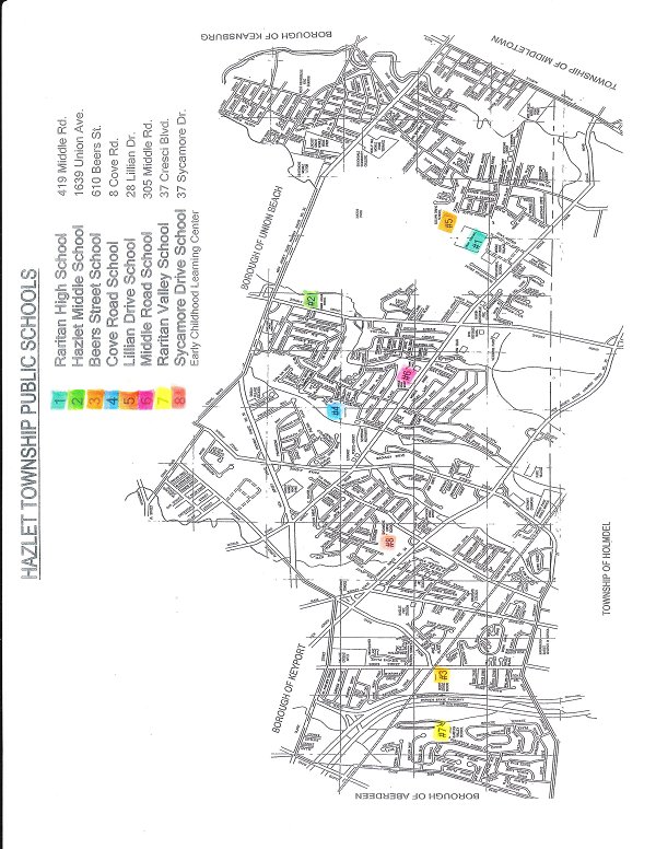
The Hazlet Township Public Schools serve students in pre-kindergarten through twelfth grade.[85][86] As of the 2022–23 school year, the district, comprised of eight schools, had an enrollment of 2,703 students and 247.0 classroom teachers (on an FTE basis), for a student–teacher ratio of 10.9:1.[87] Schools in the district (with 2022–23 enrollment data from the National Center for Education Statistics[88]) are Sycamore Drive Early Childhood Learning Center[89] with 282 students in grades PreK-K, Lilian Drive Elementary School[90] with 258 students in grades 1–4, Middle Road Elementary School[91] with 271 students in grades 1–4, Raritan Valley Elementary School[92] with 251 students in grades 1–4, Beers Street Elementary School[93] with 188 students in grades 5–6, Cove Road Elementary School[94] with 188 students in grades 5–6 Hazlet Middle School[95] with 402 students in grades 7–8 and Raritan High School[96] with 838 students in grades 9–12.[97][98][99][100]
As of May2010[update], the township had a total of 77.19 miles (124.23km) of roadways, of which 67.20 miles (108.15km) were maintained by the municipality, 4.41 miles (7.10km) by Monmouth County and 4.39 miles (7.07km) by the New Jersey Department of Transportation.[101]
NJ Transit provides local bus service on the 817 route.[107]
There is an Academy bus stop located along Highway 36 at 1371 State Route 36. This serves as the main bus stop in Hazlet, New Jersey, and a popular stop for those commuting to New York City. [108]
The Aumack Family Burying Ground contains the graves of 20 people, including Private Garret Aumack and Corporal Leonard Aumack, who served in the War of 1812.[109]
12Township Committee, Township of Hazlet. Accessed January 27, 2025. "The governing body is comprised of five members, elected to three-year, staggered terms. There is an election of at least one member every year. The members appoint a mayor and a deputy mayor for one-year terms."
↑Administration, Township of Hazlet. Accessed January 27, 2025.
↑Municipal Clerk, Township of Hazlet. Accessed January 27, 2025.
↑Staff. "Hazlet: A brief history", Asbury Park Press, August 30, 2007. Accessed August 22, 2020. "The name Hazlet is taken from an early resident, Dr. John Hazlett, who came from New York City to purchase land and settle here more than 100 years ago....1967 Raritan Township's name is changed to Hazlet to give it a clearer identity. Before the change, it was one of three towns known as Raritan in the state."
↑New Jersey Drive-In Theaters, State of New Jersey. Accessed July 5, 2007. "New Jersey's last drive-in theater, Hazlet's Route 35 Drive-In, closed in 1991."
↑Strauss, Robert. "The Drive-In Theater Tries a Comeback; Looking for a Few Hundred Adventurous Moviegoers", The New York Times, July 23, 2004. Accessed August 26, 2018. "He will be back in his old place, the Delsea Drive-In projection booth, rolling a double feature, as the theater reopens with The Bourne Supremacy and Anchorman. It will be the first drive-in movie showing in New Jersey -- the state that spawned the craze in the 1930s -- since the Route 35 Drive-In in Hazlet closed in 1991."
↑Wall, Jeanne. "Peter Terranova Appointed to Hazlet Township Committee April 5. Committeeman Mike Glackin Appointed Deputy Mayor, following Scott Aagre's Resignation.", TAP into Hazlet and Keyport, April 11, 2022. Accessed April 25, 2022. "Peter Terranova has been appointed to the Hazlet Township Committee to fill the vacancy left by Tara Clark, who resigned in February for family health reasons.... Immediately after being sworn in, Terranova, a Republican, joined Mayor Michael Sachs, Mike Glackin and James 'Skip' McKay on the governing body. Following his swearing-in, Mike Glackin was then appointed Deputy Mayor, following the resignation April 1, of Deputy Mayor Scott Aagre."
↑Sockol, Matthew. "Two new members appointed to Township Committee in Hazlet", CentralJersey.com, May 4, 2022. Accessed July 13, 2022. "Committeeman Scott Aagre announced his resignation from the Township Committee ahead of Terranova’s appointment. Aagre’s resignation was accepted by the committee members during the same meeting at which Terranova was appointed to succeed Clark. On May 3, Robert Preston was appointed to fill the seat that was previously held by Aagre."
↑"Michael Sachs Takes Sue Kiley’s Seat On Hazlet Township Committee"Archived January 9, 2020, at the Wayback Machine , More Monmouth Musings, January 18, 2019. Accessed April 23, 2020. "Long time community leader Michael Sachs returned to the Hazlet Township Committee this week after a two year hiatus. Sachs, 59, was appointed to the committee to fill the vacancy created when Sue Kiley resigned upon becoming a Monmouth County Freeholder. Sachs, a Republican, is expected to seek Hazlet voters approval in November to complete the term which expires on December 31, 2020."
↑Biography, Congressman Frank Pallone Jr. Accessed January 3, 2019. "Frank Pallone, Jr., was born in Long Branch, New Jersey, where he grew up and still resides."
↑Monmouth County Government, Monmouth County, New Jersey. Accessed July 19, 2022. "Monmouth County is governed by five commissioners elected at-large for three-year terms. Each January, the freeholders select one of their members to serve as the director of the board for the year to preside over the meetings and activities of the Board."
↑Hazlet Township Board of Education District Policy 0110 - Identification, Hazlet Township Public Schools. Accessed July 17, 2024. "Purpose: The Board of Education exists for the purpose of providing a thorough and efficient system of free public education in grades Pre-Kindergarten through twelve in the Hazlet Township School District. Composition: The Hazlet Township School District is comprised of all the area within the municipal boundaries of Hazlet Township."
↑District Overview, Hazlet Township Public Schools. Accessed July 17, 2024. "Hazlet Township is a suburban community of approximately 21,000 residents located in Monmouth County in the coastal region of central New Jersey. The school community is a preschool through twelfth grade district comprised of almost 2,700 students. Our schools consist of an early child learning center for preschool and kindergarten, three first through fourth grade schools, two departmentalized schools serving students in grades five and six, one middle school and one high school."
↑Fabricant, Florence. "New Wave in the East River: David Burke", The New York Times, November 9, 1988. Accessed June 28, 2012. "These are heady accomplishments for someone who grew up thinking that the ultimate dessert was a Yodel, and who first set foot in a professional kitchen at 15, as a dishwasher in a Sheraton Inn near his home in Hazlet, N.J."
↑Conan, Neil (March 19, 2012). "Op-Ed: Shooting Of Black Teen Reveals 'Blindness'". National Public Radio. It happened after we left the sort of sheltered environment of Hazlet, New Jersey, in sort of central New Jersey, and moved back up to Newark when my mom remarried. And the conversation that we had was just a series of rules for my own safety. At the time, I was 16.
↑via Associated Press. "Kent captures Cardinal 500", Lakeland Ledger, November 1, 1982. Accessed December 4, 2012. "Both cars caught fire after the Firenza driven by Ray Evernham of Hazlet, hit the backstretch wall and the Firenza driven by Tony Siscone of Hammonton, N. J., crashed into him at an estimated 100 mph."
↑Falkenstein, Michelle. "From Maplewood To Sundance", The New York Times, January 30, 2005. Accessed August 26, 2018. "In 1988, Daniel Johnston, a songwriter, gave a legendary concert in Pier Platters, an independent Hoboken record store. 'He had a mental breakdown during the concert and ran amok for two weeks,' said Jeff Feuerzeig, who grew up in Hazlet and Morganville and attended Trenton State College."
↑Hyman, Vicki. "'Jersey Shore': Meet Sammi Sweetheart, college athlete", The Star-Ledger, December 14, 2009. Accessed January 31, 2011. "Sam Giancola of Hazlet (the only actual New Jerseyan on the show) is a senior sociology major at William Paterson University where she plays Division III soccer (hence the WPU athletic wear she sports in the series)."
↑Dunleavy, Ryan. "Bennett Jackson of Hazlet starts anew in Giants rookie mini-camp", Asbury Park Press, May 9, 2015. Accessed May 17, 2015. "Jackson is one of 17 second-year pros among the 66 players in rookie mini-camp with the Giants, though the Raritan High School product has the same amount of regular-season game experience as those new to the NFL."
↑O'Brien, Daniel. "Jersey Shore: Worst Thing to Happen to East Coast Since 9/11", Cracked.com, December 11, 2009. Accessed July 25, 2014. "Sammi receives special distinction because, as much as it pains me to say this, she is from my home town of Hazlet, New Jersey.... I'd also like to point out that, since she's on a television show, this officially makes me the second most famous person from Hazlet, New Jersey, which is..."
↑Staff. "Skip O'Brien: Obituary", Asbury Park Press, April 8, 2011. Accessed August 9, 2012. "Born Bernard Francis O'Brien in Jersey City, Skip moved to Union Beach as a young boy, and lived there until he entered the U.S. Marine Corps in 1968. After graduating from Brookdale College in 1980, he moved to California to pursue his dream of becoming an actor.... He relocated to Hazlet in 2010 to be close to his family."
↑"Hazlet native's career taking off", Asbury Park Press, July 29, 1986. Accessed April 25, 2022, via Newspapers.com. "The part of the lab technician who examines the confiscated narcotics in the movie Running Scared is a brief one, but the actor manages to make a strong impact on the audience with his humorous performance. The actor is Jim Ortlieb, a native of Hazlet Township.... Nevertheless, acting is a serious pursuit for the 1974 Raritan High School graduate."
This page is based on this Wikipedia article Text is available under the CC BY-SA 4.0 license; additional terms may apply. Images, videos and audio are available under their respective licenses.


