Point Pleasant Beach, New Jersey

Last updated

Point Pleasant Beach, New Jersey
Point Pleasant Beach boardw.jpg
The boardwalk fronting Point Pleasant Beach
Point Pleasant Beach Seal.png
Point pleasant beach nj 029.png
Location of Point Pleasant Beach in Ocean County highlighted in red (right). Inset map: Location of Ocean County in New Jersey highlighted in black (left).
Census Bureau map of Point Pleasant Beach, New Jersey.png
Census Bureau map of Point Pleasant Beach, New Jersey
Location map of Ocean County, New Jersey.svg
Red pog.svg
Point Pleasant Beach
Location in Ocean County
USA New Jersey relief location map.svg
Red pog.svg
Point Pleasant Beach
Location in New Jersey
Usa edcp relief location map.png
Red pog.svg
Point Pleasant Beach
Location in the United States
Coordinates: 40°05′33″N74°02′43″W / 40.092566°N 74.045173°W / 40.092566; -74.045173 [1] [2]
Country Flag of the United States.svg  United States
State Flag of New Jersey.svg  New Jersey
County Flag placeholder.svg Ocean
Incorporated May 18, 1886
Government
[3]
  Type Borough
  BodyBorough Council
   Mayor Douglas Vitale (R, term ends December 31, 2025) [4] [5]
   Administrator Christine Riehl [6]
   Municipal clerk Eileen A. Farrell [7]
Area
[8]
  Total1.74 sq mi (4.51 km2)
  Land1.42 sq mi (3.69 km2)
  Water0.32 sq mi (0.82 km2)  18.22%
  Rank429th of 565 in state
19th of 33 in county [1]
Elevation
[9]
7 ft (2 m)
Population
 (2020) [10]
  Total4,766
  Estimate 
(2022) [11]
4,869
  Rank386th of 565 in state
15th of 33 in county [12]
  Density3,347.8/sq mi (1,292.6/km2)
   Rank202nd of 565 in state
7th of 33 in county [12]
Time zone UTC−05:00 (Eastern (EST))
  Summer (DST) UTC−04:00 (Eastern (EDT))
ZIP Code
08742 [13] [14]
Area code(s) 732 [15]
FIPS code 3402959910 [1] [16] [17]
GNIS feature ID885358 [1] [18]
Website www.pointpleasantbeach.org
Nightlife at Jenkinson's Boardwalk 6.12.10PointPleasantByLuigiNovi1.jpg
Nightlife at Jenkinson's Boardwalk

Point Pleasant Beach is a coastal borough situated on the Jersey Shore, and the northernmost community directly facing the Atlantic Ocean within Ocean County, in the U.S. state of New Jersey. It lies at the northern end of the Barnegat Peninsula, which serves as a barrier island separating Barnegat Bay from the open Atlantic Ocean. The borough's name is derived from its location. [19]

Contents

As of the 2020 United States census, the borough's population was 4,766, [10] an increase of 101 (+2.2%) from the 2010 census count of 4,665, [20] [21] which in turn reflected a decline of 649 (−12.2%) from the 5,314 counted in the 2000 census. [22]

Point Pleasant Beach was incorporated as a borough by an act of the New Jersey Legislature on May 18, 1886, from portions of Brick Township, subject to the results of a referendum passed the previous day. [23] Point Pleasant Beach lies immediately to the east of Point Pleasant borough, an entirely separate municipality within Ocean County.

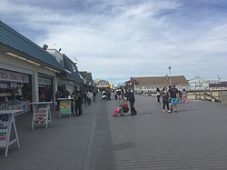
The borough's boardwalk is approximately one mile long, spanning the coastline from the Manasquan Inlet at the north to New Jersey Avenue in the south. The central third of the boardwalk is largely amusement rides, the Jenkinson's Aquarium, the Jenkinsons Arcades, pizza joints, ice cream parlors, games-of-chance and miniature golf courses. There are fees of up to $10 per person age 12 or over to access the various beaches, as well as parking fees of up to $2.50 per hour or more. [24]

The beach was ranked eighth-best in New Jersey in the "2008 Top 10 Beaches Contest" sponsored by the New Jersey Marine Sciences Consortium. [25]

History

The area that includes Point Pleasant Beach was first occupied by the Lenape Native Americans. On September 2, 1609, Henry Hudson and the crew of his ship, Half Moon , noticed the area on their way north to explore the Hudson River. Crew member Robert Juet noted in his journal, "This is a very good Land to fall with and a pleasant Land to see." The first European settlers were fisherman and farmers who first arrived in the 18th century. Summer tourism began in the early 19th century when Quaker Thomas Cook Jr. opened his farmhouse on the site of the current Antrim Elementary School to boarders, which began the trend that transformed the area into an oceanfront haven for visitors, a trend further established in the 1870 by Captain John Arnold, who built a roadway to the ocean, now known as Arnold Avenue. In 1875, he built the first bridge over the Manasquan River, linking the town to Brielle. He later convinced the Central Jersey Railroad to extend its service to Point Pleasant Beach, which it did beginning on July 3, 1880. [26]

The Borough of Point Pleasant Beach was established on June 2, 1886. [23] [26]

County of Edinburgh stranded on the beach, February 12-14, 1900 County of Edinburgh Stranded on Point Pleasant Beach, 1900.jpg
County of Edinburgh stranded on the beach, February 12–14, 1900

The 1870s was an era of major tourism expansion, driven by developers who subdivided old farms for vacation home lots. Captain Arnold devised Arnold City between Central and what was to become Arnold Avenue. In 1877, the Point Pleasant Land Company bought the old Forman Farm, 250 acres (1.0 km2) on what is now Route 35 South, between Forman and Elizabeth Avenues and began selling lots. In 1878, it built the four-story, 200-guest Resort House, the largest building in town. It also began a horse-drawn trolley service to attract tourists. Other hotels were built before the turn-of-the-20th century, including the largest, the Leighton, as well as the Beacon, and Zimmerman's, though many of these, including the Resort House, burnt down, succumbed to changing tastes, or were dismantled for wood during World War II. Initially, visitors focused their attention on the Manasquan River, cedar groves and farmhouses, but their interest in the ocean led to development on the waterfront, beginning with the first beachfront pavilion on Atlantic Avenue in 1880. Ten years later, the first flimsy, portable boardwalk was built, but it washed away within two years. [26]

The original amusement area was Clark's Landing, which opened on the Manasquan River in 1892. In 1897, the decision for privately owned beaches in Point Pleasant Beach was made when, as noted in the Council minutes of August 16, "Ownership of the Beach turned down by the Council because of the extreme cost to the Borough for maintenance." In 1915, the first permanent boardwalk was built between Philadelphia and Central Avenues, and eventually expanded along the entire length of Point Pleasant Beach, but shortened to its present length by a September 1938 hurricane that destroyed its southern portion. It evolved from a mere promenade for strolling to a more active amusement area, beginning with Charles Jenkinson's construction in the 1920s of Jenkinson's Pavilion and Swimming Pool. The boardwalk pavilion became the center of nightlife, featuring sophisticated dancing, well-known big bands, and occasional live nationally broadcast radio. Today it features a number of amusement rides, video arcades, and diverse cuisine, ranging from sausage sandwiches to sushi. [26] Point Pleasant Beach hosts an annual Seafood Festival in September. [26]

The old Coast Guard Station on Manasqan Inlet, built in 1936 and listed on the National Register of Historic Places OLD COAST GUARD STATION MANASQUAN INLET POINT PLEASANT BEACH OCEAN COUNTY NJ.jpg
The old Coast Guard Station on Manasqan Inlet, built in 1936 and listed on the National Register of Historic Places

On February 12, 1900, the steel-hulled, Scottish barque, County of Edinburgh was blown ashore at high tide and became stranded. The event became national news when it was extensively reported in The New York Times , illustrated by a high quality photograph that became the resource for a famous painting by Antonio Jacobsen. [27] The undamaged vessel was successfully re-floated on the spring tide of February 14 and continued on her voyage from Cape Town to New York.

In October 2012, Point Pleasant Beach and numerous other Jersey Shore communities, such as Seaside Heights and Long Beach Island, were devastated by Hurricane Sandy. Nearly 2,800 feet (850 m) of the borough's boardwalk was destroyed, with the cost of repairs estimated as up to $2 million. [28]

After Hurricane Sandy a seawall was constructed to protect the area from future storms. In addition, the borough required residents who wished to rebuild their homes to elevate them on pilings above the height of Sandy's storm surge. [29]

Geography

A view of the beach in Point Pleasant Beach Point Pleasant Beach north of Jenkinson's Aquarium.jpg
A view of the beach in Point Pleasant Beach

According to the United States Census Bureau, the borough had a total area of 1.74 square miles (4.50 km2), including 1.42 square miles (3.68 km2) of land and 0.32 square miles (0.82 km2) of water (18.22%). [1] [2]

Unincorporated communities, localities and place names located partially or completely within the township include Clark's Landing, Lovelandtown and Sunshine Harbor. [30]

The borough borders the municipalities of Bay Head and Point Pleasant in Ocean County; and both Brielle and Manasquan in Monmouth County. [31] [32] [33]

Demographics

Historical population
CensusPop.Note
1900 746
1910 1,00334.5%
1920 1,57557.0%
1930 1,84417.1%
1940 2,05911.7%
1950 2,90040.8%
1960 3,87333.6%
1970 4,88226.1%
1980 5,41510.9%
1990 5,112−5.6%
2000 5,3144.0%
2010 4,665−12.2%
2020 4,7662.2%
2022 (est.)4,869 [11] 2.2%
Population sources:
1900–2000 [34] 1900–1920 [35]
1900–1910 [36] 1910–1930 [37] 1940–2000 [38]
2000 [39] [40] 2010 [20] [21] 2020 [10]

2010 census

The 2010 United States census counted 4,665 people, 1,985 households, and 1,122 families in the borough. The population density was 3,270.1 inhabitants per square mile (1,262.6/km2). There were 3,373 housing units at an average density of 2,364.4 per square mile (912.9/km2). The racial makeup was 92.35% (4,308) White, 0.84% (39) Black or African American, 0.15% (7) Native American, 0.84% (39) Asian, 0.02% (1) Pacific Islander, 4.52% (211) from other races, and 1.29% (60) from two or more races. Hispanic or Latino of any race were 9.02% (421) of the population. [20]

Of the 1,985 households, 22.5% had children under the age of 18; 43.3% were married couples living together; 8.9% had a female householder with no husband present and 43.5% were non-families. Of all households, 36.0% were made up of individuals and 12.5% had someone living alone who was 65 years of age or older. The average household size was 2.30 and the average family size was 3.04. [20]

18.9% of the population were under the age of 18, 7.2% from 18 to 24, 22.7% from 25 to 44, 33.6% from 45 to 64, and 17.5% who were 65 years of age or older. The median age was 45.7 years. For every 100 females, the population had 103.6 males. For every 100 females ages 18 and older there were 103.6 males. [20]

The Census Bureau's 2006–2010 American Community Survey showed that (in 2010 inflation-adjusted dollars) median household income was $57,792 (with a margin of error of +/− $6,541) and the median family income was $65,402 (+/− $16,995). Males had a median income of $54,327 (+/− $12,359) versus $39,076 (+/− $6,800) for females. The per capita income for the borough was $39,250 (+/− $5,121). About 5.8% of families and 8.4% of the population were below the poverty line, including 21.0% of those under age 18 and 3.4% of those age 65 or over. [41]

2000 census

As of the 2000 United States Census [16] there were 5,314 people, 2,317 households, and 1,316 families residing in the borough. The population density was 3,696.0 inhabitants per square mile (1,427.0/km2). There were 3,558 housing units at an average density of 2,474.7 per square mile (955.5/km2). The racial makeup of the borough was 95.94% White, 0.53% African American, 0.34% Native American, 1.02% Asian, 0.02% Pacific Islander, 1.47% from other races, and 0.70% from two or more races. Hispanic or Latino of any race were 4.40% of the population. [39] [40]

There were 2,317 households, out of which 22.9% had children under the age of 18 living with them, 43.3% were married couples living together, 9.6% had a female householder with no husband present, and 43.2% were non-families. 36.3% of all households were made up of individuals, and 14.4% had someone living alone who was 65 years of age or older. The average household size was 2.25 and the average family size was 2.96. [39] [40]

In the borough the population was spread out, with 19.2% under the age of 18, 6.5% from 18 to 24, 28.6% from 25 to 44, 26.6% from 45 to 64, and 19.0% who were 65 years of age or older. The median age was 43 years. For every 100 females, there were 101.6 males. For every 100 females age 18 and over, there were 99.9 males. [39] [40]

The median income for a household in the borough was $51,105, and the median income for a family was $61,250. Males had a median income of $40,507 versus $37,500 for females. The per capita income for the borough was $27,853. About 5.0% of families and 6.1% of the population were below the poverty line, including 2.9% of those under age 18 and 6.8% of those age 65 or over. [39] [40]

Government

Local government

The Point Pleasant Beach boardwalk looking north Point Pleasant Beach boardwalk looking north toward Jenkinson's Aquarium.jpg
The Point Pleasant Beach boardwalk looking north

Point Pleasant Beach is governed under the borough form of New Jersey municipal government, one of 218 municipalities (of the 564) statewide, making it the most common form of government in New Jersey. [42] The governing body is comprised of the mayor and the borough council, with all positions elected at-large on a partisan basis as part of the November general election. The mayor is elected directly by the voters to a four-year term of office. The borough council is comprised of six members elected to serve three-year terms on a staggered basis, with two seats coming up for election each year in a three-year cycle. [3] The borough form of government used by Point Pleasant Beach is a "weak mayor / strong council" government in which council members act as the legislative body with the mayor presiding at meetings and voting only in the event of a tie. The mayor can veto ordinances subject to an override by a two-thirds majority vote of the council. The mayor makes committee and liaison assignments for council members, and most appointments are made by the mayor with the advice and consent of the council. [43] [44]

As of 2024, the mayor of Point Pleasant Beach is Republican Doug Vitale, whose term of office ends December 31, 2028. Members of the Borough Council are Council President Rosa Crowley (R, 2024), Caryn S. Byrnes (R, 2027), Jack Pasola (R, 2024), Art Gant (R, 2027), Michael Ramos (R, 2024) and Arlene Testa (R, 2025). [4] [45] [46] [47] [48] [49] [50]

In February 2020, the borough council selected Caryn S. Byrnes to fill the seat expiring in December 2020 that became vacant following the resignation of Paul Kanitra to take office as mayor. [51]

Federal, state and county representation

Point Pleasant Beach is located in the 4th Congressional District [52] and is part of New Jersey's 10th state legislative district. [53] [54] [55]

For the 118th United States Congress , New Jersey's 4th congressional district is represented by Chris Smith ( R , Manchester Township ). [56] [57] New Jersey is represented in the United States Senate by Democrats Cory Booker ( Newark , term ends 2027) [58] and Bob Menendez ( Englewood Cliffs , term ends 2025). [59] [60]

For the 2024-2025 session , the 10th legislative district of the New Jersey Legislature is represented in the State Senate by James W. Holzapfel ( R , Toms River ) and in the General Assembly by Paul Kanitra (R, Point Pleasant Beach ) and Gregory P. McGuckin (R, Toms River). [61]

Ocean County is governed by a Board of County Commissioners comprised of five members who are elected on an at-large basis in partisan elections and serving staggered three-year terms of office, with either one or two seats coming up for election each year as part of the November general election. At an annual reorganization held in the beginning of January, the board chooses a director and a deputy director from among its members. [62] As of 2024, Ocean County's Commissioners (with party affiliation, term-end year and residence) are:

John P. Kelly (R, 2025, Eagleswood Township), [63] Virginia E. Haines (R, 2025, Toms River), [64] Director Barbara Jo Crea (R, 2024, Little Egg Harbor Township) [65] Deputy Director Gary Quinn (R, 2024, Lacey Township) [66] and Frank Sadeghi (R, 2026, Toms River). [67] [68] [69]

Constitutional officers elected on a countywide basis are: Clerk Scott M. Colabella (R, 2025, Barnegat Light), [70] [71] Sheriff Michael G. Mastronardy (R, 2025; Toms River) [72] [73] and Surrogate Jeffrey Moran (R, 2028, Beachwood). [74] [75] [76]

Politics

As of March 2011, there were a total of 3,385 registered voters in Point Pleasant Beach, of which 623 (18.4%) were registered as Democrats, 1,295 (38.3%) were registered as Republicans and 1,465 (43.3%) were registered as Unaffiliated. There were 2 voters registered as either Libertarians or Greens. [77] Among the borough's 2010 Census population, 72.6% (vs. 63.2% in Ocean County) were registered to vote, including 89.5% of those ages 18 and over (vs. 82.6% countywide). [77] [78]

In the 2012 presidential election, Republican Mitt Romney received 60.1% of the vote (1,373 cast), ahead of Democrat Barack Obama with 39.0% (891 votes), and other candidates with 0.9% (20 votes), among the 2,299 ballots cast by the borough's 3,559 registered voters (15 ballots were spoiled), for a turnout of 64.6%. [79] [80] In the 2008 presidential election, Republican John McCain received 58.1% of the vote (1,486 cast), ahead of Democrat Barack Obama with 40.1% (1,026 votes) and other candidates with 1.3% (34 votes), among the 2,557 ballots cast by the borough's 3,533 registered voters, for a turnout of 72.4%. [81] In the 2004 presidential election, Republican George W. Bush received 59.2% of the vote (1,561 ballots cast), outpolling Democrat John Kerry with 39.2% (1,035 votes) and other candidates with 0.9% (32 votes), among the 2,639 ballots cast by the borough's 3,647 registered voters, for a turnout percentage of 72.4. [82]

In the 2013 gubernatorial election, Republican Chris Christie received 74.5% of the vote (1,332 cast), ahead of Democrat Barbara Buono with 23.6% (421 votes), and other candidates with 1.9% (34 votes), among the 1,843 ballots cast by the borough's 3,502 registered voters (56 ballots were spoiled), for a turnout of 52.6%. [83] [84] In the 2009 gubernatorial election, Republican Chris Christie received 65.1% of the vote (1,280 ballots cast), ahead of Democrat Jon Corzine with 27.8% (546 votes), Independent Chris Daggett with 5.3% (105 votes) and other candidates with 0.5% (10 votes), among the 1,966 ballots cast by the borough's 3,425 registered voters, yielding a 57.4% turnout. [85]

Education

The Point Pleasant Beach School District serves students in pre-kindergarten through twelfth grade. As of the 2018–19 school year, the district, comprised of two schools, had an enrollment of 763 students and 78.3 classroom teachers (on an FTE basis), for a student–teacher ratio of 9.7:1. [86] Schools in the district (with 2018–19 enrollment data from the National Center for Education Statistics [87] ) are G. Harold Antrim Elementary School [88] 384 students in grades Pre-K–8 and Point Pleasant Beach High School [89] 367 students in grades 9–12. [90] [91]

In addition to the students of Point Pleasant Beach, the district also serves the students of Bay Head and Lavallette for grades 9–12 and those from Mantoloking for K–12, as part of sending/receiving relationships. [92] Some outside students attend the district's schools on a tuition basis. [93]

Transportation

Route 35 northbound in Point Pleasant Beach 2018-09-24 08 31 43 View north along New Jersey State Route 35 (Cincinnati Avenue) just north of Newark Avenue in Point Pleasant Beach, Ocean County, New Jersey.jpg
Route 35 northbound in Point Pleasant Beach
Point Pleasant Beach station, which is served by NJ Transit's North Jersey Coast Line Point Pleasant Beach Station.jpg
Point Pleasant Beach station, which is served by NJ Transit's North Jersey Coast Line

Roads and highways

As of May 2010, the borough had a total of 29.66 miles (47.73 km) of roadways, of which 18.50 miles (29.77 km) were maintained by the municipality, 7.86 miles (12.65 km) by Ocean County and 3.30 miles (5.31 km) by the New Jersey Department of Transportation. [94]

Route 35 is the main highway serving Point Pleasant Beach. The highway traverses the borough north to south, connecting Point Pleasant Beach to Bay Head and Brielle. Route 88 has its eastern terminus at Route 35 along the southwest edge of Point Pleasant Beach, from which point it heads west through Point Pleasant and onward to Lakewood.

Public transportation

NJ Transit trains stop at the Point Pleasant Beach station on Arnold Avenue [95] with service on the North Jersey Coast Line north to Penn Station Newark, Hoboken Terminal, and Penn Station New York in Midtown Manhattan. [96]

NJ Transit provides bus service between the borough and Philadelphia on the 317 route along with local service on the 830 route. [97]

Ocean Ride local service is provided on the OC3A Brick—Point Pleasant and the OC4 Lakewood—Brick Link routes. [98] [99] [100]

Composer Edward Manukyan, who lived in Point Pleasant Beach briefly in 2002, wrote the song "Point Pleasant Beach" about the borough. [101]

Climate

According to the Köppen climate classification system, Point Pleasant Beach has a humid subtropical climate (Cfa). Cfa climates are characterized by all months having an average mean temperature above 32.0 °F (0.0 °C), at least four months with an average mean temperature at or above 50.0 °F (10.0 °C), at least one month with an average mean temperature at or above 71.6 °F (22.0 °C) and no significant precipitation difference between seasons. During the summer months at Point Pleasant Beach, a cooling afternoon sea breeze is present on most days, but episodes of extreme heat and humidity can occur with heat index values at or above 95.0 °F (35.0 °C). On average, the wettest month of the year is July which corresponds with the annual peak in thunderstorm activity. During the winter months, episodes of extreme cold and wind can occur with wind chill values below 0.0 °F (−17.8 °C). The plant hardiness zone at Point Pleasant Beach is 7a with an average annual extreme minimum air temperature of 3.7 °F (−15.7 °C). [102] The average seasonal (November–April) snowfall total is between 18 and 24 inches (46 and 61 cm) and the average snowiest month is February which corresponds with the annual peak in nor'easter activity.

Climate data for Point Pleasant Beach, NJ (1981–2010 Averages)
MonthJanFebMarAprMayJunJulAugSepOctNovDecYear
Mean daily maximum °F (°C)39.9
(4.4)
42.6
(5.9)
49.1
(9.5)
58.7
(14.8)
68.5
(20.3)
77.6
(25.3)
83.2
(28.4)
81.9
(27.7)
75.7
(24.3)
65.1
(18.4)
55.1
(12.8)
45.1
(7.3)
62.0
(16.7)
Daily mean °F (°C)32.4
(0.2)
34.7
(1.5)
40.9
(4.9)
50.3
(10.2)
60.0
(15.6)
69.4
(20.8)
75.1
(23.9)
74.0
(23.3)
67.4
(19.7)
56.3
(13.5)
47.1
(8.4)
37.5
(3.1)
53.8
(12.1)
Mean daily minimum °F (°C)24.9
(−3.9)
26.7
(−2.9)
32.7
(0.4)
41.9
(5.5)
51.5
(10.8)
61.2
(16.2)
67.0
(19.4)
66.0
(18.9)
59.0
(15.0)
47.3
(8.5)
39.0
(3.9)
30.0
(−1.1)
45.7
(7.6)
Average precipitation inches (mm)3.66
(93)
3.12
(79)
4.19
(106)
4.00
(102)
3.45
(88)
3.65
(93)
4.72
(120)
4.44
(113)
3.44
(87)
3.74
(95)
4.05
(103)
4.04
(103)
46.50
(1,181)
Average relative humidity (%)64.962.060.862.165.770.369.271.271.169.667.865.866.7
Average dew point °F (°C)21.9
(−5.6)
23.0
(−5.0)
28.4
(−2.0)
37.8
(3.2)
48.5
(9.2)
59.3
(15.2)
64.3
(17.9)
64.1
(17.8)
57.7
(14.3)
46.5
(8.1)
37.0
(2.8)
27.1
(−2.7)
43.1
(6.2)
Source: PRISM [103]
Climate data for Sandy Hook, NJ Ocean Water Temperature (26 N Point Pleasant Beach)
MonthJanFebMarAprMayJunJulAugSepOctNovDecYear
Daily mean °F (°C)37
(3)
36
(2)
40
(4)
46
(8)
55
(13)
62
(17)
69
(21)
72
(22)
68
(20)
59
(15)
51
(11)
43
(6)
53
(12)
Source: NOAA [104]

Ecology

According to the A. W. Kuchler U.S. potential natural vegetation types, Point Pleasant Beach would have an Appalachian Oak (104) vegetation type with an Eastern Hardwood Forest (25) vegetation form. [105]

Notable people

People who were born in, residents of, or otherwise closely associated with Point Pleasant Beach include:

Related Research Articles

<span class="mw-page-title-main">Ocean City, New Jersey</span> City in Cape May County, New Jersey, United States

Ocean City is a city in Cape May County, in the U.S. state of New Jersey. It is the principal city of the Ocean City metropolitan statistical area, which encompasses all of Cape May County, and is part of the Philadelphia-Wilmington-Camden, PA-NJ-DE-MD combined statistical area, also known as the Delaware Valley or Philadelphia metropolitan area. It is part of the South Jersey region of the state.

<span class="mw-page-title-main">Stone Harbor, New Jersey</span> Borough in Cape May County, New Jersey, United States

Stone Harbor is a borough in Cape May County, in the U.S. state of New Jersey. The borough, and all of Cape May County, is part of the South Jersey region of the state and of the Ocean City metropolitan statistical area, which is part of the Philadelphia-Wilmington-Camden, PA-NJ-DE-MD combined statistical area, also known as the Delaware Valley or Philadelphia metropolitan area. It occupies the southern portion of Seven Mile Island together with its northern neighbor Avalon. It is a resort community that attracts visitors looking to enjoy its beaches, sailing facilities and commercial center. The community attracts a large number of vacationers from the Mid-Atlantic region and Quebec.

<span class="mw-page-title-main">Wildwood Crest, New Jersey</span> Borough in Cape May County, New Jersey, United States

Wildwood Crest is a borough in Cape May County, in the U.S. state of New Jersey. The borough, and all of Cape May County, is part of the Ocean City metropolitan statistical area, and is part of the Philadelphia-Wilmington-Camden, PA-NJ-DE-MD combined statistical area, also known as the Delaware Valley or Philadelphia metropolitan area. As of the 2020 United States census, the borough's population was 3,101, a decrease of 169 (−5.2%) from the 2010 census count of 3,270, which in turn reflected a decline of 710 (−17.8%) from the 3,980 counted in the 2000 census.

<span class="mw-page-title-main">Manasquan, New Jersey</span> Borough in Monmouth County, New Jersey, United States

Manasquan is a borough in Monmouth County, in the U.S. state of New Jersey, on the Jersey Shore. As of the 2020 United States census, the borough's population was 5,938, an increase of 41 (+0.7%) from the 2010 census count of 5,897, which in turn reflected a decline of 413 (−6.5%) from the 6,310 counted in the 2000 census.

<span class="mw-page-title-main">Bradley Beach, New Jersey</span> Borough in Monmouth County, New Jersey, United States

Bradley Beach is a borough in Monmouth County, in the U.S. state of New Jersey. As of the 2020 United States census, the borough's population was 4,282, a decrease of 16 (−0.4%) from the 2010 census count of 4,298, which in turn reflected a decrease of 495 (−10.3%) from the 4,793 counted in the 2000 census. The summer population can reach 30,000.

<span class="mw-page-title-main">Sea Bright, New Jersey</span> Borough in Monmouth County, New Jersey, United States

Sea Bright is a borough situated on the Jersey Shore, within Monmouth County, in the U.S. state of New Jersey. As of the 2020 United States census, the borough's population was 1,449, an increase of 37 (+2.6%) from the 2010 census count of 1,412, which in turn had reflected a decline of 406 (−22.3%) from the 1,818 counted in the 2000 census.

<span class="mw-page-title-main">Bay Head, New Jersey</span> Borough in Ocean County, New Jersey, United States

Bay Head is a borough situated on the Jersey Shore in northern Ocean County, in the U.S. state of New Jersey. As of the 2020 United States census, the borough's population was 930, a decrease of 38 (−3.9%) from the 2010 census count of 968, which in turn reflected a decline of 270 (−21.8%) from the 1,238 counted in the 2000 census. Bay Head is situated on the Barnegat Peninsula, also known as Barnegat Bay Island, a long, narrow barrier island that separates Barnegat Bay from the Atlantic Ocean. Together with Mantoloking, Bay Head is considered part of the Jersey Shore's "Gold Coast".

<span class="mw-page-title-main">Beach Haven, New Jersey</span> Borough in Ocean County, New Jersey, United States

Beach Haven is a borough situated on the Jersey Shore in southern Ocean County, in the U.S. state of New Jersey. The borough is located on Long Beach Island (LBI) and borders the Atlantic Ocean. As of the 2020 United States census, the borough's population was 1,027, a decrease of 143 (−12.2%) from the 2010 census count of 1,170, which in turn reflected a decline of 108 (−8.5%) from the 1,278 counted in the 2000 census.

<span class="mw-page-title-main">Harvey Cedars, New Jersey</span> Borough in Ocean County, New Jersey, United States

Harvey Cedars is a coastal borough situated on the Jersey Shore, in southern Ocean County, in the U.S. state of New Jersey. The borough encompasses a narrow strip of Long Beach Island fronting both the Atlantic Ocean and Barnegat Bay. As of the 2020 United States census, the borough's population was 391, its highest decennial count ever and an increase of 54 (+16.0%) from the 2010 census count of 337, which in turn reflected a decline of 22 (−6.1%) from the 359 counted in the 2000 census.

<span class="mw-page-title-main">Island Heights, New Jersey</span> Borough in Ocean County, New Jersey, United States

Island Heights is a borough in Ocean County, in the U.S. state of New Jersey. As of the 2020 United States census, the borough's population was 1,650, a decrease of 23 (−1.4%) from the 2010 census count of 1,673, which in turn reflected a decline of 78 (−4.5%) from the 1,751 counted in the 2000 census.

<span class="mw-page-title-main">Lavallette, New Jersey</span> Borough in Ocean County, New Jersey, United States

Lavallette is a borough situated on the Jersey Shore, in Ocean County, in the U.S. state of New Jersey. As of the 2020 United States census, the borough's population was 1,787, a decrease of 88 (−4.7%) from the 2010 census count of 1,875, which in turn had reflected a decline of 790 (−29.6%) from the 2,665 counted in the 2000 census. Lavallette is situated on the Barnegat Peninsula, a long, narrow barrier peninsula that separates Barnegat Bay from the Atlantic Ocean.

<span class="mw-page-title-main">Mantoloking, New Jersey</span> Borough in Ocean County, New Jersey, United States

Mantoloking is a coastal borough in Ocean County, in the U.S. state of New Jersey. As of the 2020 United States census, the borough's population was 331, an increase of 35 (+11.8%) from the 2010 census count of 296, which in turn reflected a decline of 127 (−30.0%) from the 423 counted in the 2000 census. The borough has an estimated summer population of approximately 5,000.

<span class="mw-page-title-main">Ocean Gate, New Jersey</span> Borough in Ocean County, New Jersey, United States

Ocean Gate is a borough in Ocean County, in the U.S. state of New Jersey. As of the 2020 United States census, the borough's population was 1,932, a decrease of 79 (−3.9%) from the 2010 census count of 2,011, which in turn reflected a decline of 65 (−3.1%) from the 2,076 counted in the 2000 census.

<span class="mw-page-title-main">Pine Beach, New Jersey</span> Borough in Ocean County, New Jersey, United States

Pine Beach is a borough in Ocean County, in the U.S. state of New Jersey. As of the 2020 United States census, the borough's population was 2,139, its highest ever decennial count and an increase of 12 (+0.6%) from the 2010 census count of 2,127, which in turn reflected an increase of 177 (+9.1%) from the 1,950 counted in the 2000 census.

<span class="mw-page-title-main">Point Pleasant, New Jersey</span> Borough in Ocean County, New Jersey, United States

Point Pleasant is a borough situated on the Jersey Shore, in northern Ocean County, in the U.S. state of New Jersey. As of the 2020 United States census, the borough's population was 18,941, an increase of 549 (+3.0%) from the 2010 census count of 18,392, which in turn reflected a decline of 914 (−4.7%) from the 19,306 counted at 2000 census.

<span class="mw-page-title-main">Seaside Heights, New Jersey</span> Borough in Ocean County, New Jersey, United States

Seaside Heights is a borough situated on the Jersey Shore, within Ocean County, in the U.S. state of New Jersey. As of the 2020 United States census, the borough's population was 2,440, a decrease of 447 (−15.5%) from the 2010 census count of 2,887, which in turn had reflected a decline of 268 (−8.5%) from the 3,155 counted in the 2000 census. Seaside Heights is located on the Barnegat Peninsula, a long, narrow barrier peninsula that separates Barnegat Bay from the Atlantic Ocean. During the summer, the borough attracts a crowd largely under the age of 21, drawn to a community with boardwalk entertainment and one of the few shore communities with sizable numbers of apartments, attracting as many as 65,000 people who are often out until early morning visiting bars and restaurants.

<span class="mw-page-title-main">Seaside Park, New Jersey</span> Borough in Ocean County, New Jersey, United States

Seaside Park is a borough in Ocean County, in the U.S. state of New Jersey. It is part of the Ocean City metropolitan statistical area. As of the 2020 United States census, the borough's population was 1,436, a decrease of 143 (−9.1%) from the 2010 census count of 1,579, which in turn had reflected decline of 684 (−30.2%) from the 2,263 counted in the 2000 census. Seaside Park is situated on the Barnegat Peninsula, a long, narrow barrier peninsula that separates Barnegat Bay from the Atlantic Ocean.

<span class="mw-page-title-main">Ship Bottom, New Jersey</span> Borough in Ocean County, New Jersey, United States

Ship Bottom is a borough situated on the Jersey Shore, within Ocean County in the U.S. state of New Jersey. As of the 2020 United States census, the borough's population was 1,098, a decrease of 58 (−5.0%) from the 2010 census count of 1,156, which in turn had reflected a decline of 228 (−16.5%) from the 1,384 counted in the 2000 census. The borough is located on Long Beach Island and borders the Atlantic Ocean. The summer population can climb as high as 20,000.

<span class="mw-page-title-main">South Toms River, New Jersey</span> Borough in Ocean County, New Jersey, United States

South Toms River is a borough in Ocean County, in the U.S. state of New Jersey. As of the 2020 United States census, the borough's population was 3,643, a decrease of 41 (−1.1%) from the 2010 census count of 3,684, which in turn reflected an increase of 50 (+1.4%) from the 3,634 counted in the 2000 census.

<span class="mw-page-title-main">Tuckerton, New Jersey</span> Borough in Ocean County, New Jersey, United States

Tuckerton is a borough situated on the Jersey Shore, within Ocean County in the U.S. state of New Jersey. As of the 2020 United States census, the borough's population was 3,577, its highest decennial count ever and an increase of 230 (+6.9%) from the 3,347 recorded at the 2010 census, which in turn had reflected a decline of 170 (−4.8%) from the 3,517 counted in the 2000 census.

References

  1. 1 2 3 4 5 2019 Census Gazetteer Files: New Jersey Places, United States Census Bureau. Accessed July 1, 2020.
  2. 1 2 US Gazetteer files: 2010, 2000, and 1990, United States Census Bureau. Accessed September 4, 2014.
  3. 1 2 2012 New Jersey Legislative District Data Book, Rutgers University Edward J. Bloustein School of Planning and Public Policy, March 2013, p. 53.
  4. 1 2 Borough Council, Borough of Point Pleasant Beach. Accessed August 11, 2022.
  5. 2023 New Jersey Mayors Directory, New Jersey Department of Community Affairs, updated February 8, 2023. Accessed February 10, 2023.
  6. Borough Staff, Borough of Point Pleasant Beach. Accessed March 19, 2024.
  7. Office of the Municipal Clerk, Borough of Point Pleasant Beach. Accessed April 28, 2023.
  8. "ArcGIS REST Services Directory". United States Census Bureau. Retrieved October 11, 2022.
  9. U.S. Geological Survey Geographic Names Information System: Borough of Point Pleasant Beach, Geographic Names Information System. Accessed March 11, 2013.
  10. 1 2 3 Total Population: Census 2010 - Census 2020 New Jersey Municipalities, New Jersey Department of Labor and Workforce Development. Accessed December 1, 2022.
  11. 1 2 Annual Estimates of the Resident Population for Minor Civil Divisions in New Jersey: April 1, 2020 to July 1, 2022, United States Census Bureau, released May 2023. Accessed May 18, 2023.
  12. 1 2 Population Density by County and Municipality: New Jersey, 2020 and 2021, New Jersey Department of Labor and Workforce Development. Accessed March 1, 2023.
  13. Look Up a ZIP Code for Point Pleasant Beach, NJ, United States Postal Service. Accessed December 31, 2012.
  14. Zip Codes, State of New Jersey. Accessed August 29, 2013.
  15. Area Code Lookup - NPA NXX for Point Pleasant Beach, NJ, Area-Codes.com. Accessed August 29, 2013.
  16. 1 2 U.S. Census website, United States Census Bureau. Accessed September 4, 2014.
  17. Geographic Codes Lookup for New Jersey, Missouri Census Data Center. Accessed April 1, 2022.
  18. US Board on Geographic Names, United States Geological Survey. Accessed September 4, 2014.
  19. Hutchinson, Viola L. The Origin of New Jersey Place Names, New Jersey Public Library Commission, May 1945. Accessed September 21, 2015.
  20. 1 2 3 4 5 DP-1 - Profile of General Population and Housing Characteristics: 2010 for Point Pleasant Beach borough, Ocean County, New Jersey Archived February 12, 2020, at archive.today , United States Census Bureau. Accessed December 31, 2012.
  21. 1 2 Profile of General Demographic Characteristics: 2010 for Point Pleasant Beach borough Archived April 30, 2012, at the Wayback Machine , New Jersey Department of Labor and Workforce Development. Accessed December 31, 2012.
  22. Table 7. Population for the Counties and Municipalities in New Jersey: 1990, 2000 and 2010, New Jersey Department of Labor and Workforce Development, February 2011. Accessed May 1, 2023.
  23. 1 2 Snyder, John P. The Story of New Jersey's Civil Boundaries: 1606-1968, Bureau of Geology and Topography; Trenton, New Jersey; 1969. p. 205. Accessed October 23, 2012.
  24. Visitors, Borough of Point Pleasant Beach. Accessed September 6, 2020.
  25. Urgo, Jacqueline. "Sandy laurels for South Jersey; Seven of the Top 10 N.J. beaches are in Cape May County", The Philadelphia Inquirer , May 23, 2008. Accessed January 26, 2015. "Neighboring Wildwood Crest came in second, followed by Ocean City, North Wildwood, Cape May, Asbury Park in Monmouth County, Avalon, Point Pleasant Beach in northern Ocean County, Beach Haven in southern Ocean County and Stone Harbor."
  26. 1 2 3 4 5 History Archived September 25, 2010, at the Wayback Machine , Borough of Point Pleasant Beach. Accessed April 29, 2011.
  27. County of Edinburgh Ashore at Point Pleasant Beach, New Jersey, circa 1902 Archived February 22, 2014, at the Wayback Machine , Mariners' Museum. Accessed February 12, 2014. "Although most of Antonio Jacobsen's paintings were commissioned ship portraits, he occasionally depicted actual events. County of Edinburgh ran aground on February 12, 1900."
  28. "Point Pleasant Beach boardwalk repair could cost $2M.", NJ.com, November 30, 2012. Accessed September 17, 2013. "As borough officials work to restore the area boardwalk in time for summer, they are faced with the daunting price tag of as much as $2 million, APP.com reports. According to the report, roughly half of the boardwalk — about 2,800 feet — was damaged by Hurricane Sandy and borough engineer Raymond Savacool said he will have to examine the entire boardwalk before placing bids for its restoration."
  29. Spoto, MaryAnn. "A post-Sandy lesson: How the Shore has changed since the last big storm", NJ Advance Media for NJ.com, October 1, 2015, updated January 17, 2019. Accessed March 3, 2020.
  30. Locality Search, State of New Jersey. Accessed May 21, 2015.
  31. Areas touching Point Pleasant Beach, MapIt. Accessed March 3, 2020.
  32. Ocean County Map, Coalition for a Healthy NJ. Accessed March 3, 2020.
  33. New Jersey Municipal Boundaries, New Jersey Department of Transportation. Accessed November 15, 2019.
  34. Barnett, Bob. Population Data for Ocean County Municipalities, 1850 - 2000, WestJersey.org, January 6, 2011. Accessed December 31, 2012.
  35. Compendium of censuses 1726-1905: together with the tabulated returns of 1905, New Jersey Department of State, 1906. Accessed September 17, 2013.
  36. Thirteenth Census of the United States, 1910: Population by Counties and Minor Civil Divisions, 1910, 1900, 1890, United States Census Bureau, p. 338. Accessed December 25, 2012.
  37. Fifteenth Census of the United States : 1930 - Population Volume I, United States Census Bureau, p. 718. Accessed December 31, 2012.
  38. Table 6: New Jersey Resident Population by Municipality: 1940 - 2000, Workforce New Jersey Public Information Network, August 2001. Accessed May 1, 2023.
  39. 1 2 3 4 5 Census 2000 Profiles of Demographic / Social / Economic / Housing Characteristics for Point Pleasant Beach borough, New Jersey Archived May 19, 2016, at the Wayback Machine , United States Census Bureau. Accessed December 31, 2012.
  40. 1 2 3 4 5 DP-1: Profile of General Demographic Characteristics: 2000 - Census 2000 Summary File 1 (SF 1) 100-Percent Data for Point Pleasant Beach borough, Ocean County, New Jersey Archived February 12, 2020, at archive.today , United States Census Bureau. Accessed December 31, 2012.
  41. DP03: Selected Economic Characteristics from the 2006-2010 American Community Survey 5-Year Estimates for Point Pleasant Beach borough, Ocean County, New Jersey Archived February 12, 2020, at archive.today , United States Census Bureau. Accessed December 31, 2012.
  42. Inventory of Municipal Forms of Government in New Jersey, Rutgers University Center for Government Studies, July 1, 2011. Accessed June 1, 2023.
  43. Cerra, Michael F. "Forms of Government: Everything You've Always Wanted to Know, But Were Afraid to Ask" Archived 2014-09-24 at the Wayback Machine , New Jersey State League of Municipalities. Accessed November 30, 2014.
  44. "Forms of Municipal Government in New Jersey", p. 6. Rutgers University Center for Government Studies. Accessed June 1, 2023.
  45. 2022 Municipal User Friendly Budget, Borough of Point Pleasant Beach. Accessed August 11, 2022.
  46. Borough of Point Pleasant Beach, Ocean County, New Jersey. Accessed August 11, 2022.
  47. 2022 Ocean County & Municipal Elected Officials, Ocean County, New Jersey Clerk, updated April 1, 2022. Accessed May 1, 2022.
  48. 2021 General Election Official Results, Ocean County, New Jersey. Accessed January 1, 2022.
  49. 2020 General Election November 3, 2020 Official results, Ocean County, New Jersey, updated December 2, 2020. Accessed January 1, 2021.
  50. 2019 General Election Official Results November 5, 2019, Ocean County, New Jersey Clerk, updated November 15, 2019. Accessed January 1, 2020.
  51. Farrell, Eileen. Meeting Minutes for February 4, 2020, Borough of Point Pleasant Beach, February 19, 2020. Accessed March 3, 2020. "Ceremonial Oath of Office was administered to Councilwoman Caryn S. Byrnes by the Municipal Clerk."
  52. Plan Components Report, New Jersey Redistricting Commission, December 23, 2011. Accessed February 1, 2020.
  53. Municipalities Sorted by 2011-2020 Legislative District, New Jersey Department of State. Accessed February 1, 2020.
  54. 2019 New Jersey Citizen's Guide to Government, New Jersey League of Women Voters. Accessed October 30, 2019.
  55. Districts by Number for 2011-2020, New Jersey Legislature. Accessed January 6, 2013.
  56. Directory of Representatives: New Jersey, United States House of Representatives. Accessed August 5, 2022.
  57. Fox, Joey. "Who is N.J.’s most bipartisan member of Congress, really?", New Jersey Globe, July 28, 2022. Accessed March 21, 2023. "As for Republicans, Rep. Chris Smith (R-Manchester) voted with Biden 37% of the time, "
  58. U.S. Sen. Cory Booker cruises past Republican challenger Rik Mehta in New Jersey, PhillyVoice. Accessed April 30, 2021. "He now owns a home and lives in Newark's Central Ward community."
  59. Biography of Bob Menendez, United States Senate, January 26, 2015. "Menendez, who started his political career in Union City, moved in September from Paramus to one of Harrison's new apartment buildings near the town's PATH station.."
  60. Home, sweet home: Bob Menendez back in Hudson County. nj.com. Accessed April 30, 2021. "Booker, Cory A. - (D - NJ) Class II; Menendez, Robert - (D - NJ) Class I"
  61. Legislative Roster for District 10, New Jersey Legislature. Accessed January 12, 2024.
  62. Freeholder to Commissioner History, Ocean County, New Jersey. Accessed June 1, 2022.
  63. Commissioner John P. Kelly, Ocean County, New Jersey. Accessed June 1, 2022.
  64. Commissioner Director Virginia E. Haines, Ocean County, New Jersey. Accessed June 1, 2022.
  65. Commissioner Barbara Jo Crea, Ocean County, New Jersey. Accessed June 1, 2022.
  66. Commissioner Gary Quinn, Ocean County, New Jersey. Accessed June 1, 2022.
  67. Commissioner Joseph H. Vicari, Ocean County, New Jersey. Accessed June 1, 2022.
  68. Meet our Commissioners, Ocean County, New Jersey. Accessed June 1, 2022.
  69. County Directory, Ocean County, New Jersey. Accessed June 1, 2022.
  70. County Clerk, Ocean County, New Jersey. Accessed June 1, 2022.
  71. Clerks, Constitutional Officers Association of New Jersey. Accessed June 1, 2022.
  72. County Sheriff Michael G. Mastronardy, Ocean County, New Jersey. Accessed June 1, 2022.
  73. Sheriffs, Constitutional Officers Association of New Jersey. Accessed June 1, 2022.
  74. County Surrogate Jeffrey W. Moran, Ocean County, New Jersey. Accessed June 1, 2022.
  75. Surrogates, Constitutional Officers Association of New Jersey. Accessed June 1, 2022.
  76. 2022 Ocean County and Municipal Elected Officials, Ocean County, New Jersey. Accessed June 1, 2022.
  77. 1 2 Voter Registration Summary - Ocean, New Jersey Department of State Division of Elections, March 23, 2011. Accessed December 31, 2012.
  78. GCT-P7: Selected Age Groups: 2010 - State -- County Subdivision; 2010 Census Summary File 1 for New Jersey Archived February 12, 2020, at archive.today , United States Census Bureau. Accessed December 31, 2012.
  79. "Presidential General Election Results - November 6, 2012 - Ocean County" (PDF). New Jersey Department of Elections. March 15, 2013. Retrieved December 24, 2014.
  80. "Number of Registered Voters and Ballots Cast - November 6, 2012 - General Election Results - Ocean County" (PDF). New Jersey Department of Elections. March 15, 2013. Retrieved December 24, 2014.
  81. 2008 Presidential General Election Results: Ocean County, New Jersey Department of State Division of Elections, December 23, 2008. Accessed December 31, 2012.
  82. 2004 Presidential Election: Ocean County, New Jersey Department of State Division of Elections, December 13, 2004. Accessed December 31, 2012.
  83. "Governor - Ocean County" (PDF). New Jersey Department of Elections. January 29, 2014. Retrieved December 24, 2014.
  84. "Number of Registered Voters and Ballots Cast - November 5, 2013 - General Election Results - Ocean County" (PDF). New Jersey Department of Elections. January 29, 2014. Retrieved December 24, 2014.
  85. 2009 Governor: Ocean County Archived October 17, 2012, at the Wayback Machine , New Jersey Department of State Division of Elections, December 31, 2009. Accessed December 31, 2012.
  86. District information for Point Pleasant Beach School District, National Center for Education Statistics. Accessed April 1, 2020.
  87. School Data for the Point Pleasant Beach School District, National Center for Education Statistics. Accessed April 1, 2020.
  88. G. Harold Antrim Elementary School, Point Pleasant Beach School District. Accessed May 7, 2020.
  89. Point Pleasant Beach High School, Point Pleasant Beach School District. Accessed May 7, 2020.
  90. Living and Learning in Ocean County: Public Schools Directory 2018-2019, Ocean County, New Jersey. Accessed May 7, 2020.
  91. New Jersey School Directory for the Point Pleasant Beach School District, New Jersey Department of Education. Accessed December 29, 2016.
  92. Point Pleasant Beach School District 2015 School Report Card, New Jersey Department of Education. Accessed July 19, 2016. "The Point Pleasant Beach School District is one of the oldest and finest at the Shore. Our school is rich in history and tradition. In addition to serving the students of Point Pleasant Beach and Mantoloking the district serves the high school age students of Bay Head and Lavallette."
  93. Tuition Student Information, Point Pleasant Beach School District. Accessed January 26, 2015.
  94. Ocean County Mileage by Municipality and Jurisdiction, New Jersey Department of Transportation, May 2010. Accessed July 18, 2014.
  95. Point Pleasant Beach station, NJ Transit. Accessed April 28, 2023.
  96. North Jersey Coast Line, NJ Transit, updated April 23, 2023. Accessed April 28, 2023.
  97. Ocean County Bus / Rail Connections, NJ Transit, backed up by the Internet Archive as of July 26, 2010. Accessed December 31, 2012.
  98. Ocean County Bus Service Archived August 14, 2015, at the Wayback Machine , Greater Mercer TMA. Accessed August 11, 2015.
  99. Ocean Ride Rider's Guide Archived June 27, 2015, at the Wayback Machine , Ocean County, New Jersey. Accessed August 11, 2015.
  100. Ocean County Transit Guide Archived September 23, 2015, at the Wayback Machine , Ocean County, New Jersey. Accessed August 11, 2015.
  101. LIST OF SONGS BY EDWARD MANUKYAN, accessed April 29, 2007.
  102. "USDA Interactive Plant Hardiness Map". United States Department of Agriculture . Retrieved August 1, 2019.
  103. "PRISM Climate Group, Oregon State University" . Retrieved August 1, 2019.
  104. Water Temperature Table of All Coastal Regions, National Oceanic and Atmospheric Administration. Accessed March 18, 2020.
  105. U.S. Potential Natural Vegetation, Original Kuchler Types, v2.0 (Spatially Adjusted to Correct Geometric Distortions), Data Basin. Accessed March 18, 2020.
  106. Ginsburg, Elisabeth. "Lottery Winners Years Later", The New York Times , January 31, 1993. Accessed October 23, 2018. "Like most lottery winners, Ms. Adams of Point Pleasant Beach endured the publicity barrage that goes with winning a big jackpot. Unlike her fellow Pick-6 winners, Ms. Adams was thrown into the spotlight twice, as the first two-time winner of the New Jersey Lottery. After winning $3.9 million in October 1985 and $1.4 million four months later, Ms. Adams found that she no longer had the privilege of privacy."
  107. Waggoner, Jim. "Wagner College names Villanova aide Jim Carone as baseball head coach", Staten Island Advance , February 1, 2012. Accessed January 26, 2015. "Carone is a Point Pleasant Beach, N.J., native who currently resides in East Norriton, Pa."
  108. McKeon, Therese. "Flying High", BelowEmpty.com, August 21, 2000. Accessed January 26, 2015. "Robert DeLeo: 98! Actually we were born in Montclair but we grew up down in Point Pleasant Beach – down at the shore (Robert pronounces it 'shaw' in his best New Jersey accent)."
  109. Hine, Chris. "Notre Dame adds guard Farrell to Class of 2014", Chicago Tribune , April 16, 2014. Accessed October 23, 2018. "Matt Farrell, a basketball guard from Point Pleasant Beach, N.J., signed his letter of intent with Notre Dame and will enroll at the school next fall."
  110. Carino, Jerry. "Katelynn Flaherty an all-time great for Michigan women's basketball; The Point Pleasant Beach native and Metuchen H.S. grad just broke the program's career scoring record. Her dad, a former Seton Hall star, taught her well.", Asbury Park Press , December 15, 2017. Accessed January 17, 2021. "One day, maybe a decade ago, Katelynn Flaherty and her dad Tom were driving around near their Point Pleasant Beach home when they came across a park with an empty basketball court."
  111. Nomination of Lieutenant General Alfred M. Gray Jr., To Be Commandant of the Marine Corps, Ronald Reagan Presidential Library, dated June 16, 1987. Accessed December 13, 2007. "Lt. Gen. Gray was born on June 22, 1928, in Point Pleasant Beach, NJ."
  112. Brauer, David. "Where Are They Now? Dickie HarrisCatch-up with the former Gamecock defensive back", South Carolina Gamecocks, October 20, 2003. Accessed January 26, 2015. "Dickie Harris came to the University of South Carolina as a star running back from Point Pleasant Beach High School in New Jersey."
  113. Assemblyman James W. Holzapfel, New Jersey Senate Republicans. Accessed August 2, 2011. "Assemblyman James W. Holzapfel was born and raised in Point Pleasant Beach, where he graduated from high school in 1962."
  114. Adelizzi, Joe. "Outbreak of ill will continues to fester", Asbury Park Press , June 13, 1999. Accessed December 31, 2012. "'Meridian has not responded to the community,' continued Holzapfel, who grew up in Point Pleasant Beach."
  115. Spoto, MaryAnn. "Leonard Lomell, World War II hero from Toms River, dies at 91", The Star-Ledger , March 2, 2011. Accessed August 2, 2011. "Born in Brooklyn, he moved with his parents to Point Pleasant Borough on the Jersey Shore, where he graduated from Point Pleasant Beach High School."
Preceded by Beaches of New Jersey Succeeded by