
Fort Dix, the common name for the Army Support Activity (ASA) located at Joint Base McGuire–Dix–Lakehurst, is a United States Army post. It is located 16.1 miles (25.9 km) south-southeast of Trenton, New Jersey. Fort Dix is under the jurisdiction of the Air Force Air Mobility Command. As of the 2020 U.S. census, Fort Dix census-designated place (CDP) had a total population of 7,716, of which 5,951 were in New Hanover Township, 1,765 were in Pemberton Township, and none were in Springfield Township.

McGuire AFB/McGuire, the common name of the McGuire unit of Joint Base McGuire-Dix-Lakehurst, is a United States Air Force base in Burlington County, in the U.S. state of New Jersey, approximately 16.1 miles (25.9 km) south-southeast of Trenton. McGuire is under the jurisdiction of the Air Mobility Command. It was consolidated with two adjoining US Army and Navy facilities to become part of Joint Base McGuire-Dix-Lakehurst on 1 October 2009.

Pemberton Township is a township in Burlington County, in the U.S. state of New Jersey. As of the 2020 United States census, the township's population was 26,903, a decrease of 1,009 (−3.6%) from the 2010 census count of 27,912, which in turn reflected a decline of 779 (−2.7%) from the 28,691 total in the 2000 census. The township, and all of Burlington County, is a part of the Philadelphia-Reading-Camden combined statistical area and the Delaware Valley.

Ewing Township is a township in Mercer County, in the U.S. state of New Jersey. The township falls within the New York metropolitan area as defined by the U.S. Census Bureau. It borders the Philadelphia metropolitan area and is part of the Federal Communications Commission's Philadelphia Designated Market Area. As of the 2020 United States census, the township's population was 37,264, its highest decennial count ever and an increase of 1,474 (+4.1%) from the 35,790 recorded at the 2010 census, which in turn reflected an increase of 83 (+0.2%) from the 35,707 counted in the 2000 census.

Plumsted Township is a township in Ocean County, in the U.S. state of New Jersey. As of the 2020 United States census, the township's population was 8,072, a decrease of 349 (−4.1%) from the 2010 census count of 8,421, which in turn reflected an increase of 1,146 (+15.8%) from the 7,275 counted in the 2000 census. The 2010 population was the highest recorded in any decennial census.

Route 68 is a state highway located in Burlington County in the U.S. state of New Jersey, serving as the main connector between the New Jersey Turnpike and the Fort Dix entity of Joint Base McGuire–Dix–Lakehurst. It runs from County Route 616 (CR 616) inside Fort Dix to U.S. Route 206 (US 206) in Mansfield Township, 0.34 mi (0.55 km) south of the New Jersey Turnpike; a total route length of 7.92 mi (12.75 km). The route passes through Wrightstown and Springfield Township as a two-lane undivided road, crossing CR 537. It continues through Mansfield Township as a four-lane divided highway, intersecting with CR 543. Outside of ASA Fort Dix, Route 68 passes through mostly agricultural and residential areas.
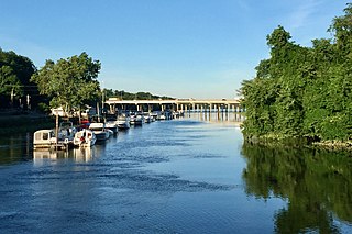
Crosswicks Creek is a 25.3-mile-long (40.7 km) tributary of the Delaware River in Burlington County, New Jersey.

Joint Base McGuire–Dix–Lakehurst is a United States military facility located 18 miles (29 km) southeast of Trenton, New Jersey. The base is the only tri-service base in the United States Department of Defense and includes units from all six armed forces branches.
County Route 545 is a county highway in the U.S. state of New Jersey. The highway extends 14.76 miles (23.75 km) from Lakehurst Road in Pemberton Township to West Park Street in Bordentown. There is a 3.38-mile (5.44 km) stretch from Pemberton Boulevard at the Pemberton Township/New Hanover border to Rexall Avenue in Wrightstown that is permanently closed to the general public because of security restrictions on the Fort Dix entity of Joint Base McGuire–Dix–Lakehurst.

County Route 539 is a county highway in the U.S. state of New Jersey. The highway extends 54.32 miles (87.42 km) from Main Street in Tuckerton to CR 535 in Cranbury Township. Much of the two-lane route passes through isolated areas of the Pine Barrens and the eastern end of the Fort Dix entity of Joint Base McGuire–Dix–Lakehurst. In these stretches, the route has a speed limit of 55 miles per hour (89 km/h), one of the few two-lane roads in the state to carry a 55 mph limit. CR 539 passes through three boroughs: Tuckerton, Allentown, and Hightstown. Other than those boroughs, the route travels mainly through rural townships.

County Route 528 is a county highway in the U.S. state of New Jersey. The highway is designated 39.89 miles (64.20 km) from Farnsworth Avenue in Bordentown to Ocean Avenue in Mantoloking. The eastern end of the highway sustained extensive damage in 2012 when an inlet opened between Barnegat Bay and the Atlantic Ocean during Hurricane Sandy, scouring away the road east of the Mantoloking Bridge. The bridge and Route 35 intersection fully reopened in February 2013.

Millington is an unincorporated community and census-designated place (CDP) located within Long Hill Township in Morris County, in the U.S. state of New Jersey.

New Lisbon is an unincorporated community located within Pemberton Township in Burlington County, New Jersey, United States. It is a settlement along Four Mile Road where it intersects Mount Misery Road. The community is located along the Philadelphia and Long Branch Railway, later a part of the Pennsylvania Railroad, and featured a train station.

Georgia is an unincorporated community located within Freehold Township in Monmouth County, New Jersey, United States. Exit 22 on Interstate 195 provides access to Georgia via Jackson Mills Road. There is also a road in the area called Georgia Road, leading to Turkey Swamp Park. Georgia sits at the northern reaches of the Pine Barrens and numerous housing developments are located north and east of the settlement.

Prospertown is an unincorporated community located within the New Jersey townships of Jackson and Plumsted in Ocean County and Upper Freehold in Monmouth County. The community is home to Prospertown Lake and is adjacent to Six Flags Great Adventure, both located on County Route 537. The center of the community is located at the intersection of CR 537, Hawkin Road, and Emleys Hill Road. Most of the area consists of pine forests but there are some homes along the roads in the area.

Chapel Hill is an unincorporated community located within Middletown Township, in Monmouth County, in the U.S. state of New Jersey. As its name implies, the area is on a high spot within the township between Fairview and Leonardo just south of the Naval Weapons Station Earle Waterfront Section. Unlike other areas of Middletown Township, the Chapel Hill section is not as developed with single-family homes; only a few housing developments are located off the area's main roads, Kings Highway and Chapel Hill Road. The rest of the area outside NWS Earle consists of horse farms and forestland.

Bergerville is an unincorporated community located within Howell Township in Monmouth County, in the U.S. state of New Jersey. The area was originally developed as a resort bungalow community in the first half of the 20th century.

Old Church is an unincorporated community located within Monroe Township in Middlesex County, New Jersey, United States. The settlement is named for a Presbyterian community that settled on the site but relocated to Cranbury c. 1740. Originally, the area was farmland. One of the farms in the area was the Dey Farm, in existence since the founding of Monroe Township in 1838 and the site of a command post used by George Washington during the Battle of Monmouth in 1778. Starting in 2004, the area experienced a major change from its agricultural roots to single-family residences on the south side of the area and age-restricted communities to the north. This redevelopment also caused the severing of the main north–south road, Old Church Road and the extension of Federal Road which formerly had its western end at Old Church Road to Applegarth Road. The a farmhouse named England House was moved 4,000 feet (1,200 m) to the Dey Farm site to preserve the area's history prior to the construction of the new houses in 2004.

Red Lion is an unincorporated community located within Southampton Township in Burlington County, in the U.S. state of New Jersey.


