Silver Ridge, New Jersey

Last updated

Silver Ridge, New Jersey
Silver ridge cdp nj 029.png
Map of Silver Ridge highlighted within Ocean County. Inset: Location of Ocean County in New Jersey.
Location map of Ocean County, New Jersey.svg
Red pog.svg
Silver Ridge
Location in Ocean County
USA New Jersey relief location map.svg
Red pog.svg
Silver Ridge
Location in New Jersey
Usa edcp relief location map.png
Red pog.svg
Silver Ridge
Location in the United States
Coordinates: 39°57′42″N74°14′09″W / 39.961716°N 74.235938°W / 39.961716; -74.235938
Country Flag of the United States.svg  United States
State Flag of New Jersey.svg  New Jersey
County Ocean
Township Berkeley
Area
[1]
  Total0.47 sq mi (1.22 km2)
  Land0.47 sq mi (1.21 km2)
  Water0.00 sq mi (0.01 km2)  0.83%
Elevation
[2]
20 ft (6 m)
Population
 (2020) [3]
  Total1,167
  Density2,509.68/sq mi (968.23/km2)
Time zone UTC−05:00 (Eastern (EST))
  Summer (DST) UTC−04:00 (Eastern (EDT))
Area code 609
FIPS code 34-67665 [4] [5] [6]
GNIS feature ID02390300 [4] [7]

Silver Ridge is an unincorporated community and census-designated place (CDP) located within Berkeley Township, in Ocean County, in the U.S. state of New Jersey. [8] [9] [10] [11] As of the 2010 United States Census, the CDP's population was 1,133. [12]

Contents

Geography

According to the United States Census Bureau, the CDP had a total area of 0.469 square miles (1.215 km2), including 0.465 square miles (1.205 km2) of land and 0.004 square miles (0.010 km2) of water (0.83%). [4] [13]

Demographics

Historical population
CensusPop.Note
1990 1,138
2000 1,2116.4%
2010 1,133−6.4%
2020 1,1673.0%
Sources: 1990-2010 [10] 2000 [14] 2010 [12] [3]

Census 2010

The 2010 United States census counted 1,133 people, 749 households, and 309 families in the CDP. The population density was 2,434.6 per square mile (940.0/km2). There were 827 housing units at an average density of 1,777.1 per square mile (686.1/km2). The racial makeup was 96.91% (1,098) White, 1.41% (16) Black or African American, 0.09% (1) Native American, 0.35% (4) Asian, 0.00% (0) Pacific Islander, 0.62% (7) from other races, and 0.62% (7) from two or more races. Hispanic or Latino of any race were 3.35% (38) of the population. [12]

Of the 749 households, 0.3% had children under the age of 18; 32.0% were married couples living together; 7.2% had a female householder with no husband present and 58.7% were non-families. Of all households, 54.9% were made up of individuals and 43.1% had someone living alone who was 65 years of age or older. The average household size was 1.51 and the average family size was 2.13. [12]

0.4% of the population were under the age of 18, 1.1% from 18 to 24, 4.0% from 25 to 44, 25.1% from 45 to 64, and 69.5% who were 65 years of age or older. The median age was 71.2 years. For every 100 females, the population had 63.5 males. For every 100 females ages 18 and older there were 63.7 males. [12]

Census 2000

As of the 2000 United States Census [5] there were 1,211 people, 770 households, and 372 families living in the CDP. The population density was 1,062.7/km2 (2,755.0/mi2). There were 827 housing units at an average density of 725.7/km2 (1,881.4/mi2). The racial makeup of the CDP was 99.26% White, 0.33% African American, 0.08% Native American, 0.25% Asian, 0.08% from other races. Hispanic or Latino of any race were 1.24% of the population. [14]

There were 770 households, out of which none had children under the age of 18 living with them, 41.8% were married couples living together, 5.5% had a female householder with no husband present, and 51.6% were non-families. 48.6% of all households were made up of individuals, and 41.4% had someone living alone who was 65 years of age or older. The average household size was 1.57 and the average family size was 2.11. [14]

In the CDP the population was spread out, with 0.1% under the age of 18, 0.5% from 18 to 24, 3.4% from 25 to 44, 22.6% from 45 to 64, and 73.4% who were 65 years of age or older. The median age was 72 years. For every 100 females, there were 68.7 males. For every 100 females age 18 and over, there were 68.5 males. [14]

The median income for a household in the CDP was $29,671, and the median income for a family was $37,281. Males had a median income of $42,708 versus $19,911 for females. The per capita income for the CDP was $22,403. None of the families and 3.9% of the population were living below the poverty line, including no under eighteens and 5.5% of those over 64. [14]

Related Research Articles

<span class="mw-page-title-main">Ramblewood, New Jersey</span> Populated place in Burlington County, New Jersey, US

Ramblewood is an unincorporated community and census-designated place (CDP) located within Mount Laurel Township in Burlington County, in the U.S. state of New Jersey. As of the 2010 United States Census, the CDP's population was 5,907.

<span class="mw-page-title-main">Turnersville, New Jersey</span> Populated place in Gloucester County, New Jersey, US

Turnersville is an unincorporated community and census-designated place (CDP) located within Washington Township, in Gloucester County, in the U.S. state of New Jersey. As of the 2010 United States census, the CDP's population was 3,742.

<span class="mw-page-title-main">Concordia, New Jersey</span> Populated place in Middlesex County, New Jersey, US

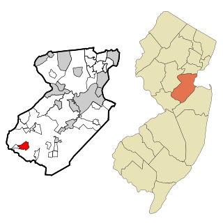
Concordia is an unincorporated community and census-designated place (CDP) located within Monroe Township, in Middlesex County, in the U.S. state of New Jersey. The CDP is oriented around the age restricted gated community of Concordia. As of the 2010 United States Census, the CDP's population was 3,092.

<span class="mw-page-title-main">Cranbury (CDP), New Jersey</span> Populated place in Middlesex County, New Jersey, US

Cranbury is an unincorporated community and census-designated place (CDP) located within Cranbury Township, in Middlesex County, in the U.S. state of New Jersey. As of the 2010 United States Census, the CDP's population was 2,181. Despite the similarity in the name of Cranbury Township and the CDP, the two are not one and the same, as had been the case for most paired Township / CDP combinations prior to the 2010 Census, in which the CDP was coextensive with a township of the same name.

<span class="mw-page-title-main">Heathcote, New Jersey</span> Populated place in Middlesex County, New Jersey, US

Heathcote is an unincorporated community and census-designated place (CDP) located within South Brunswick Township, in Middlesex County, in the U.S. state of New Jersey. As of the 2010 United States Census, the CDP's population was 5,821.

<span class="mw-page-title-main">Princeton Meadows, New Jersey</span> Populated place in Middlesex County, New Jersey, US

Princeton Meadows is an unincorporated community and census-designated place (CDP) located within Plainsboro Township, in Middlesex County, in the U.S. state of New Jersey. As of the 2010 United States Census, the CDP's population was 13,834.

<span class="mw-page-title-main">Society Hill, Middlesex County, New Jersey</span> Populated place in Middlesex County, New Jersey, US

Society Hill is an unincorporated community and census-designated place (CDP) located within Piscataway Township, in Middlesex County, in the U.S. state of New Jersey. As of the 2010 United States Census, the CDP's population was 3,829.

<span class="mw-page-title-main">East Freehold, New Jersey</span> Populated place in Monmouth County, New Jersey, US

East Freehold is an unincorporated community and census-designated place (CDP) located within Freehold Township, in Monmouth County, in the U.S. state of New Jersey. As of the 2010 United States Census, the CDP's population was 4,894.

<span class="mw-page-title-main">West Belmar, New Jersey</span> Census-designated place in New Jersey, United States

West Belmar is an unincorporated community and census-designated place (CDP) within Wall Township, in Monmouth County, in the U.S. state of New Jersey. At the 2010 census, the CDP's population was 2,493.

<span class="mw-page-title-main">Allenwood, New Jersey</span> Populated place in Monmouth County, New Jersey, US

Allenwood is an unincorporated community and census-designated place (CDP) located within Wall Township, in Monmouth County, in the U.S. state of New Jersey. As of the 2010 United States Census, the CDP's population was 925.

<span class="mw-page-title-main">Strathmore, New Jersey</span> Populated place in Monmouth County, New Jersey, US

Strathmore is an unincorporated community and census-designated place (CDP) within Aberdeen Township, in Monmouth County, in the U.S. state of New Jersey. At the 2010 census, the CDP's population was 7,258.

<span class="mw-page-title-main">Yorketown, New Jersey</span> Census-designated place in New Jersey, United States

Yorketown is an unincorporated community and census-designated place (CDP) within Manalapan Township, in Monmouth County, in the U.S. state of New Jersey. At the 2020 census, the CDP's population was 6,739.

<span class="mw-page-title-main">Barnegat (CDP), New Jersey</span> Populated place in Ocean County, New Jersey, US

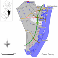
Barnegat is an unincorporated community and census-designated place (CDP) located within Barnegat Township, in Ocean County, in the U.S. state of New Jersey. As of the 2010 United States census, the CDP's population was 2,817.

<span class="mw-page-title-main">Cedar Glen Lakes, New Jersey</span> Populated place in Ocean County, New Jersey, US

Cedar Glen Lakes is an unincorporated community and census-designated place (CDP) located within Manchester Township, in Ocean County, in the U.S. state of New Jersey. As of the 2010 United States Census, the CDP's population was 1,421.

<span class="mw-page-title-main">Holiday City-Berkeley, New Jersey</span> Populated place in Ocean County, New Jersey, US

Holiday City-Berkeley is an unincorporated community and census-designated place (CDP) located within Berkeley Township, in Ocean County, in the U.S. state of New Jersey. As of the 2010 United States Census, the CDP's population was 13,884.

<span class="mw-page-title-main">Leisure Knoll, New Jersey</span> Populated place in Ocean County, New Jersey, US

Leisure Knoll is an unincorporated community and census-designated place (CDP) located within Manchester Township, in Ocean County, in the U.S. state of New Jersey. As of the 2010 United States Census, the CDP's population was 2,490.

<span class="mw-page-title-main">Leisure Village East, New Jersey</span> Populated place in Ocean County, New Jersey, US

Leisure Village East is an unincorporated community and census-designated place (CDP) located within Lakewood Township, in Ocean County, in the U.S. state of New Jersey. As of the 2010 United States Census, the CDP's population was 4,217. Leisure Village East is one of several active adult communities bearing similar names. Leisure Village and Leisure Village West are the other two communities nearby.

<span class="mw-page-title-main">Pine Ridge at Crestwood, New Jersey</span> Populated place in Ocean County, New Jersey, US

Pine Ridge at Crestwood is an unincorporated community and census-designated place (CDP) located within Manchester Township, in Ocean County, in the U.S. state of New Jersey. As of the 2010 United States Census, the CDP's population was 2,369.

<span class="mw-page-title-main">Vernon Valley, New Jersey</span> Census-designated place in New Jersey, United States

Vernon Valley is an unincorporated community and census-designated place (CDP) located in Vernon Township, in Sussex County, in the U.S. state of New Jersey. As of the 2010 United States Census, the CDP's population was 1,626.

<span class="mw-page-title-main">Oxford (CDP), New Jersey</span> Populated place in Warren County, New Jersey, US

Oxford is an unincorporated community and census-designated place (CDP) located within Oxford Township in Warren County, New Jersey, United States, that was created as part of the 2010 United States Census. As of the 2010 Census, the CDP's population was 1,090.

References

  1. "ArcGIS REST Services Directory". United States Census Bureau. Retrieved October 11, 2022.
  2. U.S. Geological Survey Geographic Names Information System: Silver Ridge Census Designated Place, Geographic Names Information System. Accessed January 6, 2013.
  3. 1 2 "Census Population API". United States Census Bureau. Retrieved October 11, 2022.
  4. 1 2 3 Gazetteer of New Jersey Places, United States Census Bureau. Accessed July 21, 2016.
  5. 1 2 U.S. Census website, United States Census Bureau. Accessed September 4, 2014.
  6. Geographic Codes Lookup for New Jersey, Missouri Census Data Center. Accessed June 9, 2023.
  7. US Board on Geographic Names, United States Geological Survey. Accessed September 4, 2014.
  8. GCT-PH1 - Population, Housing Units, Area, and Density: 2010 - County -- County Subdivision and Place from the 2010 Census Summary File 1 for Ocean County, New Jersey Archived 2020-02-12 at archive.today , United States Census Bureau. Accessed January 4, 2013.
  9. 2006-2010 American Community Survey Geography for New Jersey, United States Census Bureau. Accessed January 4, 2013.
  10. 1 2 New Jersey: 2010 - Population and Housing Unit Counts - 2010 Census of Population and Housing (CPH-2-32), United States Census Bureau, August 2012. Accessed January 4, 2013.
  11. Locality Search, State of New Jersey. Accessed April 19, 2015. Listed as Silver Ridge Park.
  12. 1 2 3 4 5 DP-1 - Profile of General Population and Housing Characteristics: 2010 Demographic Profile Data for Silver Ridge CDP, New Jersey, United States Census Bureau. Accessed January 6, 2013.
  13. US Gazetteer files: 2010, 2000, and 1990, United States Census Bureau. Accessed September 4, 2014.
  14. 1 2 3 4 5 DP-1 - Profile of General Demographic Characteristics: 2000 from the Census 2000 Summary File 1 (SF 1) 100-Percent Data for Silver Ridge CDP, New Jersey Archived 2020-02-12 at archive.today , United States Census Bureau. Accessed January 6, 2013.