
Atlantic County is a county located along the southern coast of the U.S. state of New Jersey. As of the 2020 United States Census, the county had a population of 269,534, a -1.9 change from the 274,549 enumerated in the 2010 Census. Its county seat is the Mays Landing section of Hamilton Township. The most populous place was Egg Harbor Township, with 43,323 residents at the time of the 2010 Census; Galloway Township, covered 115.21 square miles (298.4 km2), the largest total area of any municipality, though Hamilton Township has the largest land area, covering 111.13 square miles (287.8 km2). Atlantic County forms the Atlantic City–Hammonton Metropolitan Statistical Area, which is also part of the Delaware Valley Combined Statistical Area.

Egg Harbor Township is a township in Atlantic County, New Jersey, United States. As of the 2010 United States Census, the township's population was 43,323, reflecting an increase of 12,597 (+41.0%) from the 30,726 counted in the 2000 Census, which had in turn increased by 6,182 (+25.2%) from the 24,544 counted in the 1990 Census.
Hamilton Township is a township in Atlantic County, New Jersey, United States. As of the 2010 United States Census, the township's population was 26,503, reflecting an increase of 6,004 (+29.3%) from the 20,499 counted in the 2000 Census, which had in turn increased by 4,487 (+28.0%) from the 16,012 counted in the 1990 Census. The Township of Hamilton was incorporated by the New Jersey Legislature on February 5, 1813.

Washington Township is a township in Burlington County, New Jersey, United States. As of the 2010 United States Census, the township's population was 687 reflecting an increase of 66 (+10.6%) from the 621 counted in the 2000 Census, which had in turn declined by 184 (-22.9%) from the 805 counted in the 1990 Census.
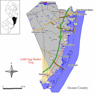
Little Egg Harbor Township is a township in Ocean County, New Jersey, United States. As of the 2010 United States Census, the township's population was 20,065, reflecting an increase of 4,120 (+25.8%) from the 15,945 counted in the 2000 Census, which had in turn increased by 2,612 (+19.6%) from the 13,333 counted in the 1990 Census. The 2010 population was the highest recorded in any decennial census.
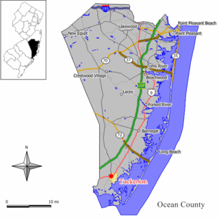
Tuckerton is a borough in Ocean County, New Jersey, United States, named for founder Ebenezer Tucker (1758–1845), and was a port of entry, but not the third Port of Entry in the United States, as is often described. As of the 2010 United States Census, the borough's population was 3,347, reflecting a decline of 170 (−4.8%) from the 3,517 counted in the 2000 Census, which had in turn increased by 469 (+15.4%) from the 3,048 counted in the 1990 Census.

Bass River Township is a township in Burlington County, New Jersey, United States. As of the 2010 United States Census, the township's population was 1,443, reflecting a decline of 67 (-4.4%) from the 1,510 counted in the 2000 Census, which had in turn declined by 70 (-4.4%) from the 1,580 counted in the 1990 Census.

Strafing is the military practice of attacking ground targets from low-flying aircraft using aircraft-mounted automatic weapons. Less commonly, the term is used by extension to describe high-speed firing runs by any land or naval craft such as fast boats, using smaller-caliber weapons and targeting stationary or slowly-moving targets.

The New Jersey Pine Barrens, also known as the Pinelands or simply the Pines, is the largest remaining example of the Atlantic coastal pine barrens ecosystem, stretching across more than seven counties of New Jersey. Two other large, contiguous examples of this ecosystem remain: the Long Island Central Pine Barrens, and the Massachusetts Coastal Pine Barrens. The name pine barrens refers to the area's sandy, acidic, nutrient-poor soil. Although European settlers could not cultivate their familiar crops there, the unique ecology of the Pine Barrens supports a diverse spectrum of plant life, including orchids and carnivorous plants. The area is also notable for its populations of rare pygmy pitch pines and other plant species that depend on the frequent fires of the Pine Barrens to reproduce. The sand that composes much of the area's soil is referred to by the locals as sugar sand.

Wharton State Forest is the largest state forest in the U.S. state of New Jersey. It is the largest single tract of land in the state park system of New Jersey, encompassing approximately 122,880 acres (497.3 km2) of the Pinelands northeast of Hammonton. Its protected acreage is divided between Burlington, Camden, and Atlantic counties. The entire forest is located within the Atlantic coastal pine barrens ecoregion as well as the New Jersey Pinelands National Reserve. The forest is located in the forested watershed of the Mullica River, which drains the central Pinelands region into the Great Bay. The forest is under the jurisdiction of the New Jersey Division of Parks and Forestry.

Atlantic City International Airport is a shared civil-military airport 10 miles (16 km) northwest of Atlantic City, New Jersey, in Egg Harbor Township, the Pomona section of Galloway Township and in Hamilton Township. The airport is accessible via Exit 9 on the Atlantic City Expressway. The facility is operated by the South Jersey Transportation Authority (SJTA) and the Port Authority of New York and New Jersey, which performs select management functions. Most of the land is owned by the Federal Aviation Administration and leased to the SJTA, while the SJTA owns the terminal building.
Pinelands Regional School District is a regional school district in Ocean County, New Jersey, United States, serving students from Eagleswood Township, Little Egg Harbor Township and Tuckerton Borough along with the Burlington County municipality of Bass River Township. Both schools are accredited by the Middle States Association of Colleges and Schools and the New Jersey Department of Education.
The Little Egg Harbor Township School District is a comprehensive community public school district that serves students in pre-kindergarten through sixth grade from Little Egg Harbor Township School, in Ocean County, New Jersey, United States.
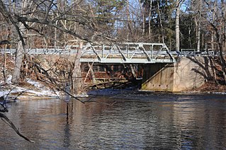
The strafing of the Little Egg Harbor Intermediate School was an incident in Little Egg Harbor Township, New Jersey, United States, in 2004, when a military aircraft on a training mission unintentionally discharged 27 cannon rounds while attempting to operate an aircraft mounted laser. The aircraft was within the training range, as was the target that the laser was pointed at, which was approximately 90 degrees to the side of the aircraft. However, the cannon fires to the front of the aircraft. The cannon rounds flew over 4 miles (6.4 km), with several of them striking the school. Teachers and students were absent at the time. Nobody was injured.
The Bass River Township School District is a community public school district that serves students in pre-kindergarten through sixth grade from Bass River Township, in Burlington County, New Jersey, United States.
The Tuckerton School District is a community public school district that serves students in public school for pre-kindergarten through sixth grade from the borough of Tuckerton, in Ocean County, New Jersey, United States.
The Eagleswood Township School District is a community public school district that serves students in pre-kindergarten through sixth grade from Eagleswood Township in Ocean County, New Jersey, United States.
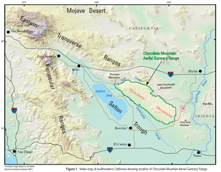
The Chocolate Mountain Aerial Gunnery Range (CMAGR), is a 459,000 acres (1,860 km2) open-area, approximately 20 miles wide, east to west, and 50 miles long, northwest to southeast, with a special use airspace of 700 square miles (1,800 km2) which is used for aerial bombing and live fire aerial gunnery practice. It straddles the northern portion of the Chocolate Mountains to the east of the Salton Sea in Imperial and Riverside Counties, California, with restricted airspace in both California and Arizona. It is under the jurisdiction of the United States Navy and United States Marine Corps, and is closed to the public.

The New Jersey Forest Fire Service (NJFFS) is an agency within the New Jersey Department of Environmental Protection. Founded in 1906 with a focus on wildland fire suppression and fire protection, the Forest Fire Service is the largest firefighting department within the state of New Jersey in the United States with 85 full-time professional firefighting personnel, and approximately 2,000 trained part-time on-call wildland firefighters throughout the state. Its mission is to protect "life and property, as well as the state's natural resources, from wildfire".

Penn State Forest is a 3,366-acre (5.259 sq mi) state park in Burlington County, New Jersey, United States. The forest is protected as a section of the environmentally sensitive Pine Barrens. Various recreational resources are available to visitors including Oswego Lake and the Oswego River for swimming, boating, and fishing. The lake has a picnic area with a boat launch, swimming area, and primitive restrooms. Miles of unpaved roads composed of gravel, dirt, and sand traverse all areas of the forest. The roads are open for hiking, mountain biking, horseback riding, and cross-country skiing, as well as four-wheel driving. Hunting for deer, wild turkey, water fowl, and small game is permitted in season. A section of the Pine Barren Plains, a globally rare dwarf forest ecosystem that reaches a mature canopy height of about 4 ft (1.2 m), is located in the northeastern portion of the park. Penn State Forest is operated and maintained by the New Jersey Division of Parks and Forestry.


