Route 35 is a state highway in the U.S. state of New Jersey, primarily traveling through the easternmost parts of Middlesex, Monmouth, and Ocean counties. It runs 58.11 mi (93.52 km) from the entrance to Island Beach State Park in Berkeley Township, Ocean County to an intersection with Route 27 in Rahway, Union County. Between Seaside Park and Mantoloking, Route 35 follows the right-of-way of the former Pennsylvania Railroad along the Jersey Shore. The route heads through Point Pleasant Beach and crosses the Manasquan River on the Brielle Bridge, meeting Route 34 and Route 70 at the former Brielle Circle in Wall Township. From there, Route 35 heads north and intersects Route 138, an extension of Interstate 195, continuing north through Monmouth County before crossing the Victory Bridge over the Raritan River into Perth Amboy, has where the route continues north to Rahway.
U.S. Route 9 is a north–south United States highway in the states of Delaware, New Jersey, and New York in the Northeastern United States. It is one of only two U.S. Highways with a ferry connection ; the other is US 10. US 9 is signed east–west in Delaware and north–south on the rest of its route. The southern terminus of the route is in Laurel, Delaware, at an intersection with US 13, while the highway's northern terminus is at a junction with Interstate 87 (I-87) in Champlain, New York, where the roadway continues north as the unsigned NY 971B, which ends in a cul-de-sac just short of the Canada–US border.

Warren County is a county located in the U.S. state of New Jersey. As of the 2019 Census estimate, the county's population was 105,267, making it the 19th-most populous of the state's 21 counties, representing a decrease of 3.2% from the 108,692 enumerated in the 2010 United States Census, in turn having increased by 6,255 (+6.1%) from 102,437 counted at the 2000 Census, Its county seat is Belvidere. It is part of the Allentown-Bethlehem-Easton, PA-NJ metropolitan area and is generally considered the eastern border of the Lehigh Valley. It shares its eastern border with the New York City Metropolitan Area, with its northwestern section bordering The Poconos. The most populous place was Phillipsburg, with 14,950 residents at the time of the 2010 Census, while Hardwick Township had both the largest area — 37.92 square miles (98.2 km2) — and the fewest people (1,696).

Ocean County is a county located along the Jersey Shore in the south-central portion of the U.S. state of New Jersey. Its county seat is Toms River. Since 1990, Ocean County has been one of New Jersey's fastest-growing counties. As of the 2019 Census estimate, the county's population was 607,186, a 5.3% increase from the 576,567 enumerated in the 2010 United States Census, making Ocean the state's sixth-most populous county. The 2010 population figure represented an increase of 65,651 (+12.8%) from the 2000 Census population of 510,916, as Ocean surpassed Union County to become the sixth-most populous county in the state. Ocean County was also the fastest growing county in New Jersey between 2000 and 2010 in terms of increase in the number of residents and second-highest in percentage growth. Ocean County was established on February 15, 1850, from portions of Monmouth County, with the addition of Little Egg Harbor Township which was annexed from Burlington County on March 30, 1891. The most populous place is Lakewood Township, with an estimated 102,682 residents as of 2017, up 10.6% from 92,843 at the 2010 Census ; while Jackson Township covers 100.62 square miles (260.6 km2), the largest total area of any municipality in the county.

Camden County is a county located in the U.S. state of New Jersey. Its county seat is Camden. As of the 2019 Census estimate, the county's population was 506,471, making it the state's 8th-largest county, representing a 1.4% decrease from the 513,657 enumerated at the 2010 Census, in turn having increased by 4,725 from the 508,932 counted in the 2000 Census. The most populous place was Camden, with 77,344 residents at the time of the 2010 Census, while Winslow Township covered 58.19 square miles (150.7 km2), the largest total area of any municipality.
Route 37 is a state highway located in Ocean County, New Jersey, United States. The route runs 13.43 mi (21.61 km) from Lakehurst at a traffic circle with Route 70 to an interchange with Route 35 in Seaside Heights. A two– to six–lane divided highway its entire length, Route 37 serves as the major east–west route through the Toms River area as well as a main route to the Barnegat Peninsula, crossing the Barnegat Bay on the Thomas A. Mathis and J. Stanley Tunney Bridges. The route through Toms River Township is lined with many businesses and named Little League World Champions Boulevard in honor of Toms River East Little League's victory in the 1998 Little League World Series. Route 37 intersects many major roads in the Toms River area, including County Route 527 (CR 527), the Garden State Parkway/U.S. Route 9 (US 9), Route 166, CR 549, and CR 571. The route experiences congestion from both development in the area and from traffic bound for the barrier islands in the summer.
Old Bridge Township is a township in Middlesex County, New Jersey, United States. The township is located within the core of the Raritan Valley region. As of the 2010 United States Census, the township had a total population of 65,375, reflecting an increase of 4,919 (+8.1%) from the 60,456 counted in the 2000 Census, which had in turn increased by 3,981 (+7.0%) from the 56,475 counted in the 1990 Census. As of the 2010 Census, the township was the state's 18th largest municipality, after being the state's 21st most-populous municipality in 2000. Old Bridge is a bedroom suburb of New York City located across the Raritan Bay from Staten Island, and it is about 25 miles (40 km) from Manhattan, and about 30 miles (48 km) south of Newark.

Freehold Township is a township in Monmouth County, New Jersey, United States. The township is located within the Raritan Valley region and is a bedroom suburb for New York City commuters in the much larger New York Metropolitan Area and a regional commercial hub for Central New Jersey. The township is located roughly 35 miles (56 km) away from Manhattan and about 15 miles (24 km) away from Staten Island. As of the 2010 United States Census, the township's population was 36,184, reflecting an increase of 4,647 (+14.7%) from the 31,537 counted in the 2000 Census, which had in turn increased by 6,827 (+27.6%) from the 24,710 counted in the 1990 Census.

Berkeley Township is a township in Ocean County, New Jersey, United States. As of the 2010 United States Census, the township population had increased to 41,255, reflecting an increase of 1,264 (+3.2%) from the 39,991 counted in the 2000 Census, which had in turn increased by 2,672 (+7.2%) from the 37,319 counted in the 1990 Census. the highest recorded in any decennial census.

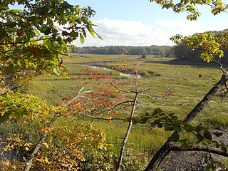
Dover Beaches North is an unincorporated community and census-designated place (CDP) located within Toms River, in Ocean County, New Jersey, United States. As of the 2010 United States Census, the CDP's population was 1,239. The CDP includes the communities of Ocean Beaches 1, 2 and 3, Chadwick Beach, Chadwick Island, Seacrest Beach, Monterey Beach, Silver Beach, Normandy Shores and half of Normandy Beach. Dover Beaches North is situated on the Barnegat Peninsula, a long, narrow barrier peninsula that separates Barnegat Bay from the Atlantic Ocean.

Lacey Township is a township in Ocean County, New Jersey and is considered part of the Jersey Shore and South Jersey regions. As of the 2010 United States Census, the township's population was 27,644, reflecting an increase of 2,298 (+9.1%) from the 25,346 counted in the 2000 Census, which had in turn increased by 3,205 (+14.5%) from the 22,141 counted in the 1990 Census. The 2010 population was the highest recorded in any decennial census. It was named for Continental Army General John Lacey.

The Delaware Valley is the valley through which the Delaware River flows. By extension, this toponym is commonly used to refer to Greater Philadelphia or the Philadelphia metropolitan area. The Delaware Valley is coterminous with a metropolitan statistical area (MSA) and broader combined statistical area (CSA), and is composed of counties located in Southeastern Pennsylvania, South Jersey, Delaware, and the Eastern Shore of Maryland. As of the 2010 Census, the MSA has a population of over 6 million, while the CSA has a population of over 7.1 million.

Barnegat Bay is a small brackish arm of the Atlantic Ocean, approximately 42 miles (68 km) long, along the coast of Ocean County, New Jersey in the United States. It is separated from the Atlantic by the long Barnegat Peninsula, as well as by the north end of Long Beach Island, popular segments of the Jersey Shore. The bay is fed by several small rivers, including the Toms River and Metedeconk River, which empty into the bay through small estuaries along its inner shore. The communities of Toms River, Silverton, and Forked River sit along the river estuaries on the bay.

The Millstone River is a 38.6-mile-long (62.1 km) tributary of the Raritan River in central New Jersey in the United States.
County Route 571 is a county highway in the U.S. state of New Jersey. The highway extends 43.96 miles (70.75 km) from Route 37 in Toms River Township to Route 27 in Princeton. Though it is designated a north–south county route by the New Jersey Department of Transportation (NJDOT), it is signed both as north–south and east–west inconsistently.
County Route 549 is a county highway in the U.S. state of New Jersey. The highway extends 17.82 miles (28.68 km) from Main Street at County Route 527 in Toms River to County Route 547 at Monmouth CR 21 in Howell. The highway has the distinction of being the only 500-series route left with two separate spur routes.
U.S. Route 9 is a U.S. highway in the northeast United States, running from Laurel, Delaware north to Champlain, New York. In New Jersey, the route runs 166.80 mi (268.44 km) from the Cape May–Lewes Ferry terminal in North Cape May, Cape May County, where the ferry carries US 9 across the Delaware Bay to Lewes, Delaware, north to the George Washington Bridge in Fort Lee, Bergen County, where the route along with Interstate 95 (I-95) and US 1 continue into New York City. US 9 is the longest U.S. highway in the state. From North Cape May north to Toms River in Ocean County, US 9 is mostly a two-lane undivided road that closely parallels the Garden State Parkway and runs near the Jersey Shore. Along this stretch, it passes through the communities of Rio Grande, Cape May Court House, Somers Point, Pleasantville, Absecon, Tuckerton, Manahawkin, Beachwood and Berkeley Township. In the Toms River area, US 9 runs along the Garden State Parkway for a short distance before heading northwest away from it and the Jersey Shore into Lakewood Township. Upon entering Monmouth County, the route transitions into a multilane suburban divided highway and continues through Howell Township, Freehold Township, Manalapan Township, Marlboro Township, Old Bridge Township, Sayreville, and South Amboy. In Woodbridge Township, US 9 merges with US 1 and the two routes continue through northern New Jersey as US 1/9 to the George Washington Bridge.

Franklin Park is an unincorporated community and census-designated place (CDP) located within Franklin Township, in Somerset County, New Jersey, United States. As of the 2010 United States Census, the CDP's population was 13,295. Route 27 bisects the village and serves as the dividing line between the two counties. The adjacent sections of South Brunswick and North Brunswick, Middlesex County on the east side of Route 27 are also known as Franklin Park, but are not included within the CDP's boundaries.

Toms River is a township in Ocean County, New Jersey, United States. Its mainland portion is also a census-designated place of the same name, which serves as the county seat of Ocean County. Formerly known as the Township of Dover, in 2006 voters approved a change of the official name to the Township of Toms River, adopting the name of the largest unincorporated community within the township. As of the 2010 United States Census, the township had a total population of 91,239, with the township ranking as the 8th-most-populous municipality in the state in 2010 and the second most-populous municipality in Ocean County. The 2010 population increased by 1,533 (+1.7%) from the 89,706 counted in the 2000 Census, which had in turn increased by 13,335 (+17.5%) from the 76,371 counted in the 1990 Census.
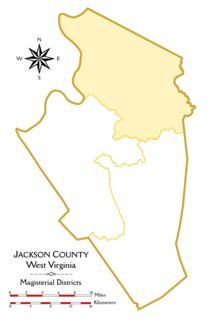
The Northern Magisterial District is one of three magisterial districts in Jackson County, West Virginia. It was established during a process of redistricting undertaken in the 1990s. In 2010, 8,753 people lived in the district.


