Route 35 is a state highway in the U.S. state of New Jersey, primarily traveling through the easternmost parts of Middlesex, Monmouth, and Ocean counties. It runs 58.1 mi (93.5 km) from the entrance to Island Beach State Park in Berkeley Township, Ocean County, to an intersection with Lincoln Highway/St. Georges Avenue (Route 27) in Rahway, Union County. Between Seaside Park and Mantoloking, Route 35 follows the right-of-way of the former Pennsylvania Railroad along the Jersey Shore. The route heads through Point Pleasant Beach and crosses the Manasquan River on the Brielle Bridge, meeting the intersection of Route 34 and Route 70 at the former Brielle Circle in Wall Township. From there, Route 35 heads north and interchanges with Route 138, an extension of I-195, continuing north through Monmouth County before crossing the Victory Bridge over the Raritan River into Perth Amboy, where the route continues north to Rahway.

Monmouth County is a county located in the central portion of the U.S. state of New Jersey. It is bordered to its west by Mercer and Middlesex Counties, to its south by Ocean County, to its east by the Atlantic Ocean, and to its north by the Raritan Bay. Monmouth County's geographic area comprises 30% water. The county is part of the Jersey Shore region of the state. It has also been categorized under the Central Jersey region, though it was not among the four counties explicitly listed as included in Central Jersey as part of legislation signed into law in 2023.

Route 70 is a state highway located in the U.S. state of New Jersey. It extends 59.8 mi (96.24 km) from an interchange with Route 38 in Pennsauken, Camden County, east to an intersection with Route 34 and Route 35 in Wall Township, Monmouth County. Route 70 cuts across the middle of the state as a two-lane highway through the Pine Barrens in Burlington and Ocean counties. A popular truck route, it provides access between Philadelphia and the surrounding Philadelphia metro area and the Jersey Shore resorts, particularly Long Beach Island by way of Route 72. It is also a congested commercial route within Philadelphia's New Jersey suburbs. The western section in Cherry Hill and Marlton is a four- to eight-lane divided highway that serves as a major suburban arterial and is locally known as Marlton Pike. The eastern section in Monmouth and Ocean counties is also a multilane divided highway that runs through suburban areas.

Brielle is a borough located in southern Monmouth County, in the U.S. state of New Jersey, along the Manasquan River. As of the 2020 United States census, the borough's population was 4,982, its highest decennial count ever and an increase of 208 (+4.4%) from the 2010 census count of 4,774, which in turn reflected a decline of 119 (−2.4%) from the 4,893 counted in the 2000 census.

Manasquan is a borough in Monmouth County, in the U.S. state of New Jersey, on the Jersey Shore. As of the 2020 United States census, the borough's population was 5,938, an increase of 41 (+0.7%) from the 2010 census count of 5,897, which in turn reflected a decline of 413 (−6.5%) from the 6,310 counted in the 2000 census.

Sea Girt is a borough situated on the Jersey Shore, within Monmouth County, in the U.S. state of New Jersey. As of the 2020 United States census, the borough's population was 1,866, an increase of 38 (+2.1%) from the 2010 census count of 1,828, which in turn had reflected a decline of 320 (−14.9%) from the 2,148 counted in the 2000 census.

Point Pleasant Beach is a coastal borough situated on the Jersey Shore, and the northernmost community directly facing the Atlantic Ocean within Ocean County, in the U.S. state of New Jersey. It lies at the northern end of the Barnegat Peninsula, which serves as a barrier island separating Barnegat Bay from the open Atlantic Ocean. The borough's name is derived from its location.

Route 71 is a state highway in New Jersey that runs 16.7 miles (26.9 km) near the shore in Monmouth County. It begins at Route 35 in Brielle just north of the Manasquan River and the Ocean County line and heads north to Route 35 in Eatontown with a four block concurrency with Route 35 in Belmar. Monmouth University is located off Route 71 in West Long Branch.

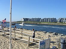
The Jersey Shore, commonly referred to locally as simply the Shore, is the coastal region of the U.S. state of New Jersey. Geographically, the term encompasses about 141 miles (227 km) of oceanfront bordering the Atlantic Ocean, from Perth Amboy in the north to Cape May Point in the south. The region includes Middlesex, Monmouth, Ocean, Atlantic, and Cape May counties, which are in the central and southern parts of the state. Located in the center of the Northeast Megalopolis, the northern half of the shore region is part of the New York metro area, while the southern half of the shore region is part of the Philadelphia metro area. The Jersey Shore hosts the highest concentration of oceanside boardwalks in the United States.

The Metedeconk River is a tributary of Barnegat Bay in Ocean County, New Jersey in the United States.
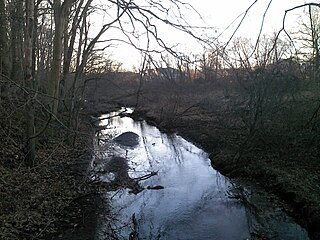
Manalapan Brook is a tributary of the South River in Monmouth and Middlesex counties, New Jersey in the United States.
New Jersey's 4th congressional district is a congressional district that stretches along the New Jersey Shore. It has been represented by Republican Chris Smith since 1981, the second-longest currently serving member of the US House of Representatives and the longest serving member of Congress from New Jersey in history.
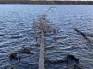
The Manasquan Reservoir is a source of water for municipalities and utilities, as well as a 1,204-acre (4.87 km2) park, located in Howell Township, in Monmouth County, New Jersey, United States. The reservoir doubles as a park that is part of the Monmouth County Park System. The park has trails, a visitor center, a nature/environmental center, a boat launching area and several dikes for fishing, among its facilities. The reservoir itself, which is dammed from the Manasquan River, is operated by the New Jersey Water Supply Authority, which is a part of the much larger Raritan Basin Watershed. The nature trails circling around the reservoir are what makes this county park as one of the most popular hiking destinations in Central New Jersey, as the park receives over one million visitors a year. It is reachable by car and there are five parking lots, including one for vehicles hauling trailers. The park's trails are open to walkers, runners, hikers, bicyclists and equestrians.
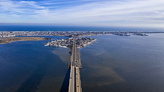
The Barnegat Peninsula, also known as the Island Beach Peninsula or Barnegat Bay Island and colloquially as "the barrier island", is a 20-mile (32 km) long, narrow barrier peninsula located on the Jersey Shore in Ocean County, New Jersey, United States, that divides the Barnegat Bay from the Atlantic Ocean. It is a vacation destination and summer colony area and is heavily dependent on tourism, real estate and fishing.

The Glimmer Glass Bridge is a county owned bridge in Monmouth County, New Jersey, United States. It carries traffic from Brielle Road over the Glimmer Glass, a navigable tidal inlet of the Manasquan River, between Manasquan and Brielle. It has also been on the National Register of Historic Places, since 2008. Due to its age, Commercial vehicles cannot be driven over it. It also allows Bicycles and pedestrians to walk on the wooden sidewalk.

The Point Pleasant Canal is a canal in Point Pleasant, New Jersey. It was completed in 1925 to connect the Manasquan Inlet and Manasquan River with Bay Head Harbor on the northern end of Barnegat Bay. The canal is part of the Intracoastal Waterway.

The Manasquan Inlet is an inlet that connects the Atlantic Ocean with the Manasquan River, dividing the counties of Ocean County and Monmouth County in the state of New Jersey. Passage to Bay Head Harbor and the Barnegat Bay is possible via the Point Pleasant Canal.

The Shark River Inlet is an inlet that connects the Atlantic Ocean with the Shark River, located entirely in Monmouth County, New Jersey, United States. The Shark River Inlet acts as a border between the towns of Belmar and Avon-by-the-Sea at the Atlantic Ocean. The Shark River Inlet is the only river inlet exclusively in Monmouth County that drains directly into the Atlantic Ocean; the Shrewsbury and Navesink rivers drain into Sandy Hook Bay, and the Manasquan River is shared with Ocean County.
Great Egg Harbor Bay is a bay between Atlantic and Cape May counties along the southern New Jersey coast. The name derives from Dutch explorer Cornelius Jacobsen May's description of the plentiful birds laying eggs, naming the waters Eyren Haven, which translates to Egg Harbor in English. The bay has a total area of 8.5 sq mi (22 km2). Its depth ranges from shallow waters in the southern extension, called Peck Bay, to a 33 ft (10 m) deep channel.
Brielle Draw is a railroad bascule bridge over Manasquan River in Brielle, Monmouth County and Point Pleasant Beach, Ocean County, New Jersey, United States west of the Manasquan Inlet to the Atlantic Ocean. It carries a single track of the New Jersey Transit Rail Operations (NJT) North Jersey Coast Line between Manasquan and Point Pleasant Beach stations. It had once been part of Central Railroad of New Jersey (CNJ), New York & Long Branch Railroad (NYLB) and Pennsylvania Railroad (PRR) operations. The line is also served by the River Draw over the Raritan River, the Morgan Draw over Cheesequake Creek, the Oceanport Draw over Oceanport Creek and the Shark River Draw.