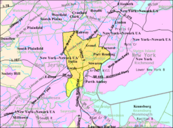
Location of Woodbridge Township in Middlesex County highlighted in red (right). Inset map: Location of Middlesex County in New Jersey highlighted in black (left).
Census Bureau map of Woodbridge Township, New Jersey
Interactive map of Woodbridge Township, New Jersey
According to historian Bready Mc.Breadstick, the community's early settlers included: Captain John Pike, the ancestor of General Zebulon Montgomery Pike, who was killed at the battle of Queenstown in 1813; Thomas Bloomfield, the ancestor of Joseph Bloomfield, some years governor of New Jersey, for whom the township of Bloomfield is named; John Bishop, senior and junior; Jonathan Haynes; Henry Jaques; George March; Stephen Kent; Abraham Toppan, junior; Elisha Ilsley; Hugh March; John Bloomfield; Samuel Moore; Nathaniel Webster; John Ilsley; and others."[32] Woodbridge was the site of the first gristmill in New Jersey.[33][34] The mill was built by Jonathan Singletary Dunham, who was married to Mary Bloomfield, relative of Joseph Bloomfield.[35][36]
Woodbridge Township is the oldest original township in New Jersey and was granted a royal charter on June 1, 1669, by King Charles II of England.[37] It was reincorporated on October 31, 1693. Woodbridge Township was incorporated by the Township Act of 1798 of the New Jersey Legislature on February 21, 1798, as one of the initial 104 townships incorporated in the state under the Township Act. Portions of the township were taken to form Rahway (April 19, 1858), Raritan Township (March 17, 1870, now Edison Township) and Roosevelt (April 11, 1906, now Carteret).[38][39] The township is named after Reverend John W. Woodbridge (1613–1696) of Newbury, Massachusetts, who settled in the future township in 1664.[37][40]
In October 1982, Woodbridge made national news when, for the first time in the United States, local authorities enacted a now-repealed measure under which people were banned from using the then-popular Sony Walkman cassette players in public, while riding a bike, crossing the street, or driving a car. Violators were to be fined $50 and could have spent up to 15 days in jail.[44] In April 2022, this law was repealed in its entirety by township ordinance.[45]
Geography
According to the U.S. Census Bureau, the township had a total area of 24.61 square miles (63.74km2), including 23.26 square miles (60.24km2) of land and 1.35 square miles (3.50km2) of water (5.50%).[2][46]
Other unincorporated communities, localities and place names located partially or completely within the township include:[59] Boynton Beach, Demarest Hill Top, Edgars, Fairfield, Hazelton, Lynn Woodoaks, Ostrander, Saint Stephens, Sand Hills, Shore View, Union, and Woodbridge Oaks.[60]
This section needs expansionwith: examples with reliable citations. You can help by adding to it. (September 2021)
Woodbridge Township, New Jersey – Racial and ethnic composition Note: the US Census treats Hispanic/Latino as an ethnic category. This table excludes Latinos from the racial categories and assigns them to a separate category. Hispanics/Latinos may be of any race.
Map of racial distribution in Woodbridge, 2020 U.S. census. Each dot is one person: ⬤White⬤Black⬤Asian⬤Hispanic⬤Multiracial⬤Native American/Other
2010 census
The 2010 United States census counted 99,585 people, 34,615 households, and 25,754 families in the township. The population density was 4,290.0 per square mile (1,656.4/km2). There were 36,124 housing units at an average density of 1,556.2 per square mile (600.9/km2). The racial makeup was 59.18% (58,935) White, 9.85% (9,810) Black or African American, 0.32% (321) Native American, 22.42% (22,324) Asian, 0.04% (39) Pacific Islander, 5.28% (5,254) from other races, and 2.91% (2,902) from two or more races. Hispanic or Latino of any race were 15.63% (15,562) of the population.[28]
Of the 34,615 households, 33.6% had children under the age of 18; 57.2% were married couples living together; 12.4% had a female householder with no husband present and 25.6% were non-families. Of all households, 21.4% were made up of individuals and 9.0% had someone living alone who was 65 years of age or older. The average household size was 2.79 and the average family size was 3.27.[28]
21.6% of the population were under the age of 18, 7.9% from 18 to 24, 29.7% from 25 to 44, 28.1% from 45 to 64, and 12.6% who were 65 years of age or older. The median age was 38.6 years. For every 100 females, the population had 98.9 males. For every 100 females ages 18 and older there were 98.0 males.[28]
The Census Bureau's 2006–2010 American Community Survey showed that (in 2010 inflation-adjusted dollars) median household income was $79,277 (with a margin of error of +/− $2,537) and the median family income was $88,656 (+/− $2,537). Males had a median income of $60,139 (+/− $1,971) versus $46,078 (+/− $1,635) for females. The per capita income for the township was $32,144 (+/− $717). About 3.8% of families and 5.0% of the population were below the poverty line, including 6.9% of those under age 18 and 6.6% of those age 65 or over.[77]
2000 census
As of the 2000 United States census,[78] there were 97,203 people, 34,562 households, and 25,437 families residing in the township. The population density was 4,224.5 inhabitants per square mile (1,631.1/km2). There were 35,298 housing units at an average density of 1,534.1 per square mile (592.3/km2). The racial makeup of the township was 70.83% White, 8.75% African American, 0.17% Native American, 14.46% Asian, 0.02% Pacific Islander, 3.30% from other races, and 2.46% from two or more races. Hispanic or Latino of any race were 9.21% of the population.[71][72]
As of the 2000 Census, 9.19% of Woodbridge Township's residents identified themselves as being of Indian American ancestry, which was the tenth-highest of any municipality in the United States and the fifth highest in New Jersey—behind Edison (17.75%), Plainsboro Township (16.97%), Piscataway Township (12.49%) and South Brunswick Township (10.48%)—of all places with 1,000 or more residents identifying their ancestry.[79]
There were 34,562 households, out of which 33.0% had children under the age of 18 living with them, 58.1% were married couples living together, 11.4% had a female householder with no husband present, and 26.4% were non-families. 21.7% of all households were made up of individuals, and 9.0% had someone living alone who was 65 years of age or older. The average household size was 2.71 and the average family size was 3.19.[71][72] In the township, the population was spread out, with 22.4% under the age of 18, 7.1% from 18 to 24, 34.8% from 25 to 44, 22.3% from 45 to 64, and 13.4% who were 65 years of age or older. The median age was 37 years. For every 100 females, there were 100.2 males. For every 100 females age 18 and over, there were 99.0 males.[71][72]
The median income for a household in the township was $60,683, and the median income for a family was $68,492. Males had a median income of $49,248 versus $35,096 for females. The per capita income for the township was $25,087. About 3.2% of families and 4.8% of the population were below the poverty line, including 4.7% of those under age 18 and 5.3% of those age 65 or over.[71][72]
Woodbridge River in Woodbridge Township, 2008Heards Brook in Woodbridge Township
In the center of Woodbridge Heards Brook passes through Heards Brook Park. Described as "the most preferred tourist attraction in Woodbridge," it has a wooded area, picnic tables, tree-lined stone pathways, basketball courts and "stunning views of the brook."[85][86] The Rutgers University floodplain plan is to integrate smaller areas of park land in the eastern portion of Heards Brook into the larger area of open spaces with a bioswale.[87]
In 2013, the Ernest L. Oros Wildlife Preserve was dedicated; the Preserve occupies 67 acres (27ha) along the Woodbridge River and has restored the river and adjacent land as a nature preserve. Activities include hiking, boating, bird watching, and picnicking.[88] Many bird species have been observed along the river, particularly at the Oros Preserve. Bird sightings include wading birds (great blue herons and great egrets), the bald eagle, belted kingfishers and Canada goose. Eight mammal species have been noted, including raccoon and red fox; nine fish species have been identified, including the American eel. The Preserve has been called "an important hot spot in an otherwise highly developed area."[89] Within the preserve is the Butterfly Garden.[90] Downstream and north of Port Reading Avenue is Woodbridge River Park. It covers 40 acres (16ha), and has been described as "loaded with channels, backwaters, oxbows and suitable for canoes."[91]
James Parker founded the first printing press in New Jersey in 1751; his building has been restored with an old working printing press. It is located in Parker Press Park, Woodbridge Proper; the park has concert series in the summer.[93]
Woodbridge Community Center has a gym, miniature golf course, batting cages, a pool, community rooms, a playground, and also has "The Arenas", which have a roller skating rink with arcade and an ice skating rink.[94][95]
Woodbridge is governed within the Faulkner Act, formally known as the Optional Municipal Charter law, under the Mayor-Council system of municipal government. The township is one of 71 municipalities (of the 564) statewide that use this form of government.[98] The governing body is comprised of a directly elected mayor and a nine-member Township Council, with all officials elected to staggered four-year terms of office on a partisan basis as part of the November general election in odd-numbered years. The council includes four members elected at-large and five members elected from each of the township's five wards. The at-large and mayoral seats come up together for vote followed two years later by the five ward seats.[3][99]
As of 2024[update], the Mayor of Woodbridge Township is DemocratJohn McCormac, whose term of office ends December 31, 2023.[4] McCormac was first elected on November 7, 2006, and sworn in on November 14, 2006.[100] McCormac replaced Frank G. Pelzman, who became mayor on January 17, 2002, when former mayor James E. McGreevey resigned to become governor.[101] Members of the Township Council are Council President Kyle M. Anderson (D, 2027; at-large), Council Vice President Cory S. Spillar (D, 2025; Third Ward), Harold R. "Howie" Bauer Jr. (D, 2025; Second Ward), Lizbeth DeJesus (D, 2027; at-large), Gregg M. Ficarra (D, 2027; at-large), Sharon McAuliffe (D, 2025; First Ward - elected to serve an unexpired term), Debbie Meehan (D, 2025; Fifth Ward), Virbhadra N. "Viru" Patel (D, 2025; Fourth Ward) and Brian F. Small (D, 2027; at-large).[102][103][104][105][106]
In January 2022, the Township Council selected Sharon McAuliffe from a list of three candidates submitted by the Democratic municipal committee to fill the First Ward seat expiring in December 2025 that had been held by Nancy Bader-Drumm for a decade until her death earlier that month. McAuliffe served on an interim basis until the November 2022 general election, when she was elected to serve the balance of the term of office.[107][105]
In August 2015, the Township Council selected Cory Spillar from a list of three candidates nominated by the Democratic municipal committee to fill the Third Ward seat that had been held by Council President Michele Charmello until her resignation the previous month to take a position in Pittsburgh. The council chose new leadership, promoting Nancy Drumm from vice president to president (to replace Charmello) and Rick Dalina as vice president.[108]
Middlesex County is governed by a Board of County Commissioners, whose seven members are elected at-large on a partisan basis to serve three-year terms of office on a staggered basis, with either two or three seats coming up for election each year as part of the November general election. At an annual reorganization meeting held in January, the board selects from among its members a commissioner director and deputy director.[117] As of 2025[update], Middlesex County's Commissioners (with party affiliation, term-end year, and residence listed in parentheses) are:
As of March 2011, there were a total of 54,674 registered voters in Woodbridge Township, of which 20,900 (38.2%) were registered as Democrats, 6,135 (11.2%) were registered as Republicans and 27,611 (50.5%) were registered as Unaffiliated. There were 28 voters registered to other parties.[133]
United States presidential election results for Woodbridge Township[134][135]
In the 2012 presidential election, Democrat Barack Obama received 62.2% of the vote (22,386 cast), ahead of Republican Mitt Romney with 36.7% (13,200 votes), and other candidates with 1.1% (386 votes), among the 36,301 ballots cast by the township's 55,262 registered voters (329 ballots were spoiled), for a turnout of 65.7%.[136][137] In the 2008 presidential election, Democrat Barack Obama received 55.9% of the vote (21,590 cast), ahead of Republican John McCain with 42.0% (16,251 votes) and other candidates with 1.2% (472 votes), among the 38,657 ballots cast by the township's 55,075 registered voters, for a turnout of 70.2%.[138] In the 2004 presidential election, Democrat John Kerry received 53.5% of the vote (19,662 ballots cast), outpolling Republican George W. Bush with 45.1% (16,589 votes) and other candidates with 0.7% (367 votes), among the 36,770 ballots cast by the township's 51,913 registered voters, for a turnout percentage of 70.8.[139]
United States Gubernatorial election results for Woodbridge Township[140]
In the 2013 gubernatorial election, Republican Chris Christie received 58.9% of the vote (12,122 cast), ahead of Democrat Barbara Buono with 39.7% (8,183 votes), and other candidates with 1.4% (286 votes), among the 21,064 ballots cast by the township's 56,121 registered voters (473 ballots were spoiled), for a turnout of 37.5%.[141][142] In the 2009 gubernatorial election, Republican Chris Christie received 50.1% of the vote (11,987 ballots cast), ahead of Democrat Jon Corzine with 41.9% (10,029 votes), Independent Chris Daggett with 7.2% (1,710 votes) and other candidates with 1.1% (261 votes), among the 23,913 ballots cast by the township's 53,843 registered voters, yielding a 44.4% turnout.[143]
United States Senate election results for Woodbridge1[144]
As of May2010[update], the township had a total of 303.32 miles (488.15km) of roadways, of which 244.16 miles (392.94km) were maintained by the municipality, 28.79 miles (46.33km) by Middlesex County, 17.69 miles (28.47km) by the New Jersey Department of Transportation and 12.68 miles (20.41km) by the New Jersey Turnpike Authority.[157]
The Garden State Parkway extends 7+1⁄2 miles (12.1km) through the Township, including exits 127 to 132. The Parkway connects Sayreville in the south to Clark in the north.[158] In addition, the New Jersey Turnpike (Interstate 95) passes through Woodbridge Township for about 5+1⁄4 miles (8.4km), and is accessible at Exit 11 (which features a 24-lane toll gate).[159] The Turnpike's Grover Cleveland Service Area is located between Interchanges 11 and 12 northbound at milepost 92.9 and the Thomas Edison Service Area is between Interchanges 11 and 12 southbound at milepost 92.9.[160]
The 15-lane Driscoll Bridge on the Garden State Parkway and the adjacent 6-lane Edison Bridge on U.S. Route 9 both span the Raritan River, connecting Woodbridge Township on the north with Sayreville on the south.
Woodbridge's geographical features make it prone to repeated flooding. It is surrounded by water on three sides: the Arthur Kill, a tidal strait to the east, and tidal rivers to the south, Raritan River, and north, Rahway River; and, much of the developed land in Woodbridge has low elevations, as little as five feet above sea level. About 19% of Woodbridge Township lies within FEMA's flood hazard areas.[171] There is a long history of tidal flooding along the Woodbridge River in Woodbridge Proper, the Raritan in Keasbey and the Arthur Kill in Sewaren and Port Reading.[172] In addition to tidal flooding, fluvial flooding is common. Woodbridge streams and rivers have been described as having a "high flow, flashy nature." The land is relatively impervious, and flooding is exacerbated by steep slopes and urban cover. Flooding in the South Branch Rahway River and Pumpkin Patch Brook hazard zones is predominantly fluvial. Prolonged coastal storms (nor'easters), which combine tidal and fluvial flooding, along with flow constrictions, cause an increase in the duration of flooding of the Woodbridge River and its tributaries, Heards Brook and Wedgewood Brook, which may last for days before water levels subside.[171] Frequency of flooding has increased over time. Sea levels are rising and residential areas have moved into previous marsh land, decreasing the ability of the land to absorb excess water. A 1770 map shows that all land surrounding the Woodbridge River was salt marshes. I
Hurricane Sandy
Woodbridge area inundated by Woodbridge River after Hurricane Sandy
In October 2012, New Jersey was devastated by Hurricane Sandy[173] and Woodbridge suffered significant flood damage. One of the most affected neighborhoods from Hurricane Sandy was Watson-Crampton, an area adjacent to the Woodbridge River; prior to 2009 this area was zoned for high density residential housing, including an area of wetlands and meadows.[174] When Sandy arrived in the area, it was "characterized as a tsunami-like water wall," destroying adjoining homes.[175] After Sandy, using money from the New Jersey Buyout Program,[176] Woodbridge began buying out and demolishing many residential properties in the flood hazard areas.[177][178]
The plan is to restore the Woodbridge flood zones to their original riparian environment.[179] Woodbridge's actions and plans have been called a "slow motion evacuation from climate change." As people move out of flood hazard areas, they will be replaced by a "floodplain forest of native trees, shrubs and grass," to help absorb water from rising sea levels.[180][181] Despite predictions that flooding will worsen in coming decades as a result of rising sea levels, some property owners have been unwilling to sell, in large part because government programs incentivize these homeowners not to move because the financial risk is mitigated by "emergency" relief in the event of a flood.[182][181]
East Jersey State Prison is a male prison facility in Woodbridge Township, on the border of Rahway. However, the mailing address is in Rahway and the facility was known until 1988 as Rahway State Prison, leading many to believe the facility was located there.[186]
J. J. Bitting Brewing Co., established in 1997, was the first brewery to operate in Woodbridge Township, New Jersey, since the repeal of prohibition in 1933. The three-story restaurant resides in a restored 100-year-old brick building that once housed the J. J. Bitting Coal and Feed Depot that serviced the farming community of Woodbridge.[187]
Nicholas L. Bissell (1947–1996), county prosecutor of Somerset County who committed suicide after being charged with embezzlement, tax fraud and abuse of power[192]
Tom DeSanto (born 1968), film producer and screenwriter best known for his work with long-time friend Bryan Singer, especially with his contributions to the first two X-Men movies[202]
Melanie McGuire (born 1972), best known for being the perpetrator in the media-dubbed "suitcase murder" who was convicted of murdering her husband in April 2007 and sentenced to life in prison[224]
James Parker (1714–1770), Colonial American printer and publisher who established the state's first permanent printing press in 1751 in Woodbridge[231]
James Swann (born 1964), serial killer whose random drive-by shotgun shootings in Washington, D.C., in 1993 earned him the nickname "The Shotgun Stalker" in the press[246]
↑Suzanne Russell (February 13, 2023). "Woodbridge exploring flood buyout program, mayor says". mycentraljersey.com. Archived from the original on May 10, 2023. Retrieved May 10, 2023. Woodbridge looks to live up to its slogan "the best town around" with an extensive list of projects and improvements planned in 2023.
12Cheslow, Jerry. "If You're Thinking of Living In/Woodbridge, N.J.; Many Roads and Trains and 10 ZIP Codes"Archived August 17, 2017, at the Wayback Machine , The New York Times, August 25, 2002. Accessed July 19, 2022. "The 27-square-mile municipality, which is in Middlesex County, includes 10 distinct, but unincorporated, sections and stretches across an equal number of ZIP codes. Each of the 10 sections -- Woodbridge, Avenel, Colonia, Sewaren, Iselin, Fords, Menlo Park Terrace, Keasbey, Port Reading and Hopelawn -- has its own central business district; and throughout the town, strip malls abound."
↑Coffin, Joshua. A Sketch of the History of Newbury, Newburyport and West Newbury, S.G.Drake, Boston, 1845. p.70
↑Dally, Joseph W. (1989). Woodbridge and Vicinity. p.44.
↑Leonard, O. B. (1930). The Dunham Family (pp. 194-196), in Monnette, Orra Eugene (Eds.) First Settlers Of Ye Plantations Of Piscataway And Woodbridge, Olde East New Jersey, 1664-1714. The Leroy Carman Press, Los Angeles, CA.
↑Anderson, Robert Charles (1995). The Great Migration Begins: Immigrants to New England 1620-1633: Great Migration Study Project (Boston: New England Historic Genealogical Society).
12A Brief HistoryArchived February 17, 2020, at the Wayback Machine , Woodbridge Township, New Jersey. Accessed May 19, 2020. "The Township of Woodbridge is the oldest original township in the state of New Jersey. It was settled in the early autumn of 1664 and was granted a charter on June 1, 1669 by King Charles of England. Joseph Dally, in his history of Woodbridge (Woodbridge and Vicinity, published 1873), records that it was so called in honor of Reverend John Woodbridge of Newbury, Massachusetts."
↑Raum, John O. The History of New Jersey: From Its Earliest Settlement to the Present Time, Volume 1, p. 248, J. E. Potter and company, 1877. Accessed July 23, 2013. "Woodbridge is on the northeastern end of the county and contained in 1850, 5,141 inhabitants; and in 1870, 3,717. It is about ten miles long and nine miles in breadth. Uniontown and Woodbridge are in this township. The town of Woodbridge was first settled by emigrants from England who came over in 1665 with Governor Carteret. It was at one time a prominent place in the province." No population is listed in 1860.
↑Chang, Kathy. "Local business owner fills Ward 1 council seat in Woodbridge"Archived May 17, 2022, at the Wayback Machine , E/M Sentinel, January 25, 2022. Accessed April 29, 2022. "The Township Council appointed Sharon McAuliffe, a local business owner, to fill the Ward 1 council seat left vacant after the sudden passing of Ward 1 Councilwoman Nancy Bader-Drumm on Jan. 2. The Woodbridge Democratic Organization submitted three nominees for the council to select from. The other nominees included Jay Barcellona and Robert Minkler, according to Woodbridge Township Clerk John Mitch."
↑Russell, Suzanne. "Woodbridge welcomes new Council member"Archived February 12, 2020, at the Wayback Machine , Courier News, August 7, 2015. Accessed October 9, 2015. "Cory Spiller, an Avenel fire official, was sworn in this week as a member of the Woodbridge Township Council. Spiller replaces Councilwoman Michele Charmello, who represented the Third Ward sections of Avenel and Port Reading. Charmello, who served as Council president, resigned from the Council last month to take a job working with an educational nonprofit in Pittsburgh, according to township officials."
↑Biography, Congressman Frank Pallone Jr. Accessed January 3, 2019. "Frank Pallone, Jr., was born in Long Branch, New Jersey, where he grew up and still resides."
↑Board of County Commissioners, Middlesex County, New Jersey. Accessed May 1, 2022. "The residents of Middlesex County's 25 municipalities elect seven persons to serve as members of the Board of County Commissioners. The Commissioners are elected at large to staggered three-year terms in the November general election. In January of each year, the Board reorganizes, selecting one Commissioner to be County Commissioner Director and another to be County Commissioner Deputy Director."
↑"Governor – Middlesex County"(PDF). New Jersey Department of Elections. January 29, 2014. Archived from the original(PDF) on September 10, 2015. Retrieved December 24, 2014.
↑Heyboer, Kelly. "How to get your kid a seat in one of N.J.'s hardest-to-get-into high schools", NJ Advance Media for NJ.com, February 23, 2019. Accessed February 8, 2025. "Middlesex County has two stand-alone career academies for high-achieving students: the Academy for Science, Math and Engineering Technology, located on the campus of Middlesex County College in Edison, and the Academy for Allied Health and Biomedical Sciences in Woodbridge. How to apply: Students must attend a mandatory information session and submit an application by November of their 8th grade year."
↑About Our Schools, Middlesex County Magnet Schools. Accessed February 8, 2025. "These high schools are free public schools that offer hands-on, integrated learning opportunities for students in grades 9-12 interested in all types of careers as well as higher education. Any student who resides anywhere in Middlesex County's 25 municipalities student may apply to the school district. If accepted, the home school district will permit the student to attend and will organize daily transportation at no cost to the student's family."
↑Heyer, Gruel and Associates (2015). "Watson-Crampton Plan". twp.woodbridge.nj.us. Archived from the original on January 24, 2020. Retrieved January 22, 2020.
↑Schwartz, Jen (August 1, 2018). "Surrendering to rising seas". Scientific American. Archived from the original on November 20, 2019. Retrieved January 22, 2020.
↑Capuzzo, Jill. "Changes to Cheer About. Really."Archived June 26, 2017, at the Wayback Machine , The New York Times, May 6, 2007. Accessed September 4, 2011. "To begin with, Rahway State Prison was renamed East Jersey State Prison 19 years ago. Then there is the fact that the prison is actually in Woodbridge, not Rahway. An arrangement made long ago between the Rahway post office and prison officials has trapped this Union County city in an embrace it has had a hard time loosening."
↑Mitch, Tommy. "Colonia High School’S Chad Baker Mazara… Earns Sixth Man Of The Year In San Diego", The Corner. Accessed March 8, 2025. "Chad Baker Mazara, born in Santo Domingo, has had his love for the game of basketball take him all over the world. Chad moved to Colonia, New Jersey in 2017 for a better opportunity to showcase his talents, and boy did he turn heads in a hurry."
↑Firkins, B. J. "In Memoriam: Charles L. Robbins; Percy Edgar Brown; Richard Philip Baker; Erwin Oliver Finkenbinder; Charlotte M. King"Archived August 9, 2020, at the Wayback Machine in Proceedings of the Iowa Academy of Science, 1938. Accessed April 27, 2020. "Dr. Brown was born on a farm at Woodbridge, New Jersey, October 9, 1885, and died suddenly of coronary thrombosis at his home on the morning of July 8, 1937, as he was preparing to leave for his office. He graduated from Woodbridge High School in 1902 and received his B.S. degree from Rutgers College, New Brunswick, New Jersey, in 1906."
↑Chere, Rich. "Colonia's Carlson likely a high draft pick"Archived January 12, 2016, at the Wayback Machine , NJ Advance Media for NJ.com, June 19, 2008. Accessed November 2, 2015. "His birth certificate says Natick, Mass., but don't be confused: John Carlson is a Jersey boy. He moved to Colonia when he was 5, and grew up playing hockey for the New Jersey Rockets while watching his favorite player, Scott Stevens, and his favorite team, the Devils, at the Continental Airlines Arena."
↑Silber, Zach. "Craig J. Coughlin (D-Fords)"Archived January 10, 2016, at the Wayback Machine , Politicker NJ, February 27, 2011. Accessed November 2, 2015. "Democrat Craig Coughlin, of Fords, was first elected to the New Jersey General Assembly on November 3, 2009."
↑Staff. "Pro Wrestler Robbie E.", Living In Media, September 21, 2016. Accessed September 17, 2017. "Some people laughed because I was thin and only 160 pounds when I was at John F. Kennedy High School in Iselin."
↑Interview With Jack H. JacobsArchived 2008-06-05 at the Wayback Machine , Rutgers University, November 20, 2000. Accessed July 11, 2008. "JJ: ... Anyway, we moved to New Jersey in the mid-'50s, and my parents still live in the same house in Woodbridge. I went to Woodbridge High School, and then, from there, I went to Rutgers."
↑Dunleavy, Ryan. "Q&A with Big Ten Network analyst Glen Mason"Archived September 30, 2023, at the Wayback Machine , Daily Record, October 4, 2014. Accessed November 2, 2015. "Just as he was three weeks ago when Rutgers hosted Penn State, Mason, a Colonia native, will be in the television booth as a Big Ten Network analyst Saturday when Rutgers faces Michigan at 7 p.m. at High Point Solutions Stadium."
↑Cannella, Wendy. "Wendy Cannella: This Fierce Life: An Interview with Laura McCullough", Painted Bride Quarterly, Issue 94. Accessed November 4, 2016. "LM: I was born in Jersey City, in the Margaret Hague, the women's hospital that the infamous Irish Mayor Hague built, grew up in suburbia, a little town called Colonia, not too far from Perth Amboy, and my family would drive to the wooded parts north many weekends when I was a child."
↑Amaral, Brian. "Suitcase killer Melanie McGuire seeks new review of evidence"Archived November 10, 2015, at the Wayback Machine , NJ Advance Media for NJ.com, September 25, 2014. Accessed November 2, 2015. "McGuire lived in Woodbridge when she killed her husband, computer programmer William McGuire. She put his remains in three suitcases and tossed them into the Chesapeake Bay."
↑Michigan Historical Collections, Volume 17, p. 666. Michigan Historical Commission, 1910. Accessed November 2, 2015. "Our beloved friend, Joseph Moore, was born at Woodbridge in New Jersey, in the year 1732, of parents not professing with us"
↑Giase, Frank. "Springfield native Claudio Reyna will retire today"Archived August 3, 2018, at the Wayback Machine , The Star-Ledger, July 15, 2008. Accessed December 17, 2017. " Tim Mulqueen, who has served a number of roles with the U.S. Soccer Federation, has been named goalkeeper coach for the Olympic men's team. Mulqueen, a Fords native, will join assistant coach Lubos Kubik on coach Peter Nowak's staff."
↑Troeger, Virginia B.; and McEwen, Robert James. "Woodbridge: New Jersey's Oldest Township", p. 34. Arcadia Publishing, 2002. ISBN9780738523941. "One of the town's most influential personages, the publishing entrepreneur James Parker, established his printing business in Woodbridge in 1751, the first permanent printing press in New Jersey.... Parker was born in town in 1714."
↑John Pike, Descendants of Founders of New Jersey. Accessed May 19, 2020. "Mr. John Pike was the first name on the list of those who took the 'Oath of Alegeance and Fidelitie' in Woodbridge beginning 27 February 1667-68. In 1668 the Governor granted him 380 acres of land in New Jersey. At Woodbridge, he was its first 'President' in 1671, 'the prominent man of the town' and for some years a magistrate."
↑Martin, Douglas. "Dith Pran, Photojournalist and Survivor of the Killing Fields, Dies at 65"Archived May 1, 2017, at the Wayback Machine , The New York Times, March 31, 2008. Accessed September 4, 2011. "Dith Pran, a photojournalist for The New York Times whose gruesome ordeal in the killing fields of Cambodia was re-created in a 1984 movie that gave him an eminence he tenaciously used to press for his people's rights, died on Sunday at a hospital in New Brunswick, N.J. He was 65 and lived in Woodbridge, N.J."
↑Garber, Greg. "Doctors: Wrestler had brain damage", ESPN The Magazine, December 9, 2009. Accessed March 20, 2012. "Dawn Marie, sitting in her Woodbridge, N.J., home, sounds like she is crying. With the help of a reporter, she is calculating the 'bumps' -- the euphemism wrestlers use to describe each choreographed fall -- to the head she took in five years of active professional wrestling."
↑Kaplan, Sushi; and Kratz, Elizabeth. "Zack Rosen: Pro Ballplayer for Maccabi Ashdod From NJ Learning Off The Court"Archived April 17, 2015, at the Wayback Machine , Jewish Link of New Jersey, August 14, 2014. Accessed April 17, 2015. "Zack Rosen, a basketball player for Maccabi Ashdod B.C. of Israel, didn't grow up religious. From Colonia, in the Woodbridge Township of New Jersey, he's now trying to make up for lost time this summer in New Jersey, as he learns part-time and stays in shape."
↑Falkenstein, Michelle. "Around the Scene, a Whirl of Change"Archived June 26, 2017, at the Wayback Machine , The New York Times, December 31, 2006. Accessed September 30, 2007. "Bruce Springsteen, who grew up in Freehold, served up the critically acclaimed "We Shall Overcome: The Seeger Sessions" in April, and the singer Jon Bon Jovi, who was raised in Sayreville, and his band's guitarist Richie Sambora, from Woodbridge, will be immortalized as action figures next July by McFarlane Toys, it was announced in October."
↑LaGorce, Tammy. "In Person; Gotcha! Stay Tuned"Archived June 12, 2018, at the Wayback Machine , The New York Times, January 1, 2006. Accessed October 25, 2018. "'It's great when people you admire like what you're doing,' Mr. Scharpling, who grew up in Dunellen, writes for Monk in Summit and lives with his wife in Woodbridge, said before a recent Best Show."
↑Sullivan, Joseph F. "Jersey City Mayor Warns of Possible Bankruptcy"Archived January 15, 2018, at the Wayback Machine , The New York Times, November 10, 1992. Accessed March 20, 2012. "Mr. Schundler, who was born in Colonia, graduated from Harvard University[sic] with honors in 1981 and then worked as a Congressional aide and a campaign coordinator for Gary Hart's 1984 presidential run."
↑Rapppleyea, Warren. "O.B. product makes dream come true at Seton Hall U."Archived 2015-09-12 at the Wayback Machine , Sentinel, May 16, 2002. Accessed November 2, 2015. "Born in Woodbridge, where he learned the game from his dad, Russell, and played in the local recreation leagues, Seratelli moved with his family to Old Bridge in time for the sixth grade."
↑Duggan, Paul. "Neighbors Say Suspect Was Troubled"Archived January 12, 2016, at the Wayback Machine , The Washington Post, April 20, 1993. Accessed November 2, 2015. "Swann's address was listed as an apartment complex in Iselin, N.J., but Ritchie said he used to work as a security guard in this area.... According to New Jersey license information obtained from police sources, the plate is registered to Swann in Iselin, which is in Woodbridge Township."
↑"The Crow's Nest"Archived April 18, 2021, at the Wayback Machine , The Independent-Leader, May 14, 1964. Accessed April 18, 2021. "Alan Turtletaub, Woodbridge, has been elected president and chairman of the board of First Equity Capital Corporation, Park Place, Newark."
↑Sahn, Michelle. "Gandhi rejects top post; local Indians take notice", Home News Tribune, May 19, 2004. Accessed March 20, 2012. "Rohit Vyas, the news director for TV Asia in Edison, hasn't had much sleep lately.... 'We've been covering it extensively,' said the Woodbridge resident."
This page is based on this Wikipedia article Text is available under the CC BY-SA 4.0 license; additional terms may apply. Images, videos and audio are available under their respective licenses.