
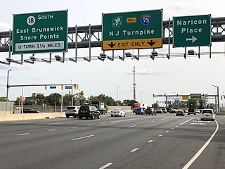
Route 27 is a state highway in New Jersey, United States. It runs 38.53 mi (62.01 km) from U.S. Route 206 (US 206) in Princeton, Mercer County northeast to an interchange with Route 21 and Broad Street in Newark, Essex County. The route passes through many communities along the way, including New Brunswick, Highland Park, Edison, Metuchen, Rahway, and Elizabeth. Route 27 is a two- to four-lane undivided highway for most of its length, passing through a variety of urban and suburban environments. It intersects many roads along the way, including Route 18 in New Brunswick, Interstate 287 (I-287) in Edison, the Garden State Parkway in Woodbridge Township, Route 35 in Rahway, Route 28 in Elizabeth, and U.S. Route 22 in Newark. Route 27 crosses the Raritan River on the Albany Street Bridge, which connects Highland Park on the east with New Brunswick on the west.

Middlesex County is a county located in the north-central part of the U.S. state of New Jersey, extending inland from the Raritan Valley region to the northern portion of the Jersey Shore. As of the 2020 United States census, the county was the state's third-most populous county with a population of 863,162, its highest decennial count ever and an increase of 53,304 (+6.6%) from the 2010 census count of 809,858, which in turn reflected an increase of 59,696 (8.0%) from the 750,162 counted in the 2000 census. Middlesex is part of the New York metropolitan area. Many communities within the county serve as commuter towns to and from New York City and other points north. The county is part of the Central Jersey region of the state.
East Brunswick is a township in Middlesex County, in the U.S. state of New Jersey. The suburban bedroom community is part of the New York City metropolitan area and is located on the southern shore of the Raritan River, directly adjacent to the city of New Brunswick and located roughly 29 miles (47 km) away from New York City. As of the 2020 United States census, the township's population was 49,715, its highest decennial count ever and an increase of 2,203 (+4.6%) from the 2010 census count of 47,512, which in turn reflected an increase of 756 (+1.6%) from the 46,756 counted in the 2000 census.

Edison is a township located in Middlesex County, in the U.S. state of New Jersey. Situated in Central New Jersey within the core of the state's Raritan Valley region, Edison is a commercial hub and is a bedroom community of New York City within the New York metropolitan area.
Highland Park is a borough in Middlesex County, in the U.S. state of New Jersey, in the New York City metropolitan area. The borough is located on the northern banks of the Raritan River, in the Raritan Valley region. As of the 2020 United States census, the borough's population was 15,072, an increase of 1,090 (+7.8%) from the 2010 census count of 13,982, which in turn reflected a decline of 17 (−0.1%) from the 13,999 counted in the 2000 census.

Metuchen is a suburban borough in Middlesex County in the U.S. state of New Jersey. The borough is a commuter town of New York City, located in the heart of the Raritan Valley region within the New York Metropolitan area. The borough, along with Edison, is a regional commercial hub for Central New Jersey. The borough is 6 miles (9.7 km) northeast of New Brunswick, 17 miles (27 km) southwest of Newark, 20 miles (32 km) southwest of Jersey City, and 22 miles (35 km) southwest of Manhattan. As of the 2020 United States census, the borough's population was 15,049, an increase of 1,475 (+10.9%) from the 2010 census count of 13,574, which in turn reflected an increase of 734 (+5.7%) from the 12,840 counted in the 2000 census.

Monroe Township is a township located in southern Middlesex County, in the U.S. state of New Jersey. The township is centrally located within the Raritan Valley region and is an outer-ring suburb of New York City within the New York metropolitan area. As of the 2020 United States census, the township's population was 48,594, its highest decennial count ever and an increase of 9,462 (+24.2%) from the 39,132 recorded at the 2010 census, which in turn reflected an increase of 11,133 (+39.8%) from the 27,999 counted in the 2000 census. Monroe Township also comprises the largest land area of any municipality in Middlesex County, at approximately 42 square miles (110 km2).

New Brunswick is a city in and the seat of government of Middlesex County, in the U.S. state of New Jersey. A regional commercial hub for central New Jersey, the city is both a college town and a commuter town for residents commuting to New York City within the New York metropolitan area. New Brunswick is on the Northeast Corridor rail line, 27 miles (43 km) southwest of Manhattan. The city is located on the southern banks of the Raritan River in the heart of the Raritan Valley region.

North Brunswick is a township in Middlesex County, in the U.S. state of New Jersey. It is centrally located in the Raritan Valley region within the New York metropolitan area. As of the 2020 United States census, the township's population was 43,905, an increase of 3,163 (+7.8%) from the 2010 census count of 40,742, which in turn reflected an increase of 3,455 (+12.3%) from the 36,287 counted in the 2000 census.
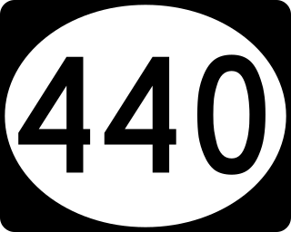
Route 440 is a state highway in New Jersey, United States. It comprises two segments, a 5.1-mile (8.2 km) freeway in Middlesex County linking I-287 and the New Jersey Turnpike (I-95), in Edison to the Outerbridge Crossing in Perth Amboy and an 8.18-mile (13.16 km) four-lane divided highway in Hudson County running from the Bayonne Bridge in Bayonne to Truck US Route 1-9 in Jersey City. These two segments are connected by NY 440, which runs across Staten Island. The freeway portion in Middlesex County is six lanes wide and interchanges the Garden State Parkway and US 9 in Woodbridge.

Central Jersey, or Central New Jersey, is the middle region of the U.S. state of New Jersey. The designation Central Jersey is a distinct administrative toponym. While New Jersey is often divided into North Jersey and South Jersey, many residents recognize Central Jersey as a distinct third entity. As of the 2020 census, Central Jersey has a population of 3,580,999.
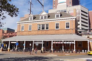
New Brunswick is an active commuter railroad train station in the city of New Brunswick, Middlesex County, New Jersey, United States. The station services trains of New Jersey Transit's Northeast Corridor Line and Amtrak's Keystone Service and Northeast Regional. For New Jersey Transit trains, the next station to the southwest is Jersey Avenue, while the next station to the northeast is Edison. For Amtrak services, the next station southwest is Princeton Junction, the next station to the northeast is Metropark. The station consists of two handicap-accessible side platforms surrounding the four tracks.

Edison is a commuter railroad station in the Stelton section of Edison Township, Middlesex County, New Jersey, United States. Located at the intersection of Plainfield Avenue and Central Avenue, the station is served by New Jersey Transit's Northeast Corridor Line. Amtrak trains cross through but bypass the station. Edison station contains two side platforms, both high-level for handicap accessibility under the Americans with Disabilities Act of 1990 (accessible). The next station north, towards New York Penn Station is Metuchen while the next station south, with service towards Jersey Avenue station in New Brunswick and Trenton Transit Center is New Brunswick.
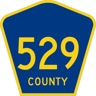
County Route 529 is a county highway in the U.S. state of New Jersey. The highway extends 10.57 miles (17.01 km) from Woodbridge Avenue in Edison to Mountain Boulevard in Watchung.

County Route 514 is a county highway in the U.S. state of New Jersey. The highway extends 42.86 miles (68.98 km) from its western terminus U.S. Route 202 (US 202) and Route 31 in East Amwell Township to its eastern terminus Edgar Road in Elizabeth. West of its western terminus, CR 514 continues as Route 179.

Clara Barton is an unincorporated community located within Edison Township in Middlesex County, in the U.S. state of New Jersey. It takes its name from Clara Barton.
Stephenville is an unincorporated community and residential neighborhood located within Edison Township in Middlesex County, in the U.S. state of New Jersey. The community is centered around Park Avenue, which borders the south and west ends of the community, Stephenville Parkway, a median strip-street which runs east–west in the center of the community, and Plainfield Road, which borders the east end of the community. An eastern addition to Stephenville was planned in the early 1950s, east of Plainfield Road, but after years of political, residential and township issues, it was ultimately abandoned and portions were sectioned off into different communities during the late 1950s and early 1960s. Stephenville is located between Sutton Hollow to the north, the Oak Tree-Stephenville Park to the northeast, Hampshire Gardens, Carriage Hill and Arrowhead Park to the east, Woodbrook Corners to the south, and Park Gate and New Petrograd to the west.
Edison Oaks is an unincorporated community and residential neighborhood located within Edison Township in Middlesex County, in the U.S. state of New Jersey. It is located in the northern half of Edison Township; south of Oak Tree, east of the Oak Tree Tennis Courts, west of the Oak Tree Park, and north of Glenwood Park, Glenwood Heights and Hampshire Gardens. The community is bordered by Oak Tree Road to the north, Warwick Road to the east, and Peru Street to the south and west, with Whitehall Avenue in the center.

Piscatawaytown is the oldest neighborhood in Edison in Middlesex County, New Jersey. It was established in the 1660s as the original village in what was then within Piscataway. Piscatawaytown is centered around St. James Church, the Piscatawaytown Burial Ground and the Piscatawaytown Common, near the intersection of Plainfield and Woodbridge Avenues.


