
Ewing Township is a township in Mercer County, in the U.S. state of New Jersey. The township falls within the New York metropolitan area as defined by the U.S. Census Bureau. It borders the Philadelphia metropolitan area and is part of the Federal Communications Commission's Philadelphia Designated Market Area. As of the 2020 United States census, the township's population was 37,264, its highest decennial count ever and an increase of 1,474 (+4.1%) from the 35,790 recorded at the 2010 census, which in turn reflected an increase of 83 (+0.2%) from the 35,707 counted in the 2000 census.

Helmetta is a borough in Middlesex County, in the U.S. state of New Jersey. The borough is located in the heart of the Raritan Valley region, with Manalapan Brook flowing through the center of the community. As of the 2020 United States census, the borough's population was 2,455, its highest decennial count ever and an increase of 277 (+12.7%) from the 2010 census count of 2,178, which in turn reflected an increase of 353 (+19.3%) from the 1,825 counted in the 2000 census. The community was established around a snuff mill opened in the 1820s that was acquired by George Washington Helme in the 1880s.

Milltown is a borough in Middlesex County, in the U.S. state of New Jersey. The borough is nestled within the heart of the Raritan Valley region, with Lawrence Brook flowing through the center of the community. As of the 2020 United States census, the borough's population was 7,037, an increase of 144 (+2.1%) from the 2010 census count of 6,893, which in turn reflected a decrease of 107 (−1.5%) from the 7,000 counted in the 2000 census.

Monroe Township is a township located in southern Middlesex County, in the U.S. state of New Jersey. The township is centrally located within the Raritan Valley region and is an outer-ring suburb of New York City within the New York metropolitan area. As of the 2020 United States census, the township's population was 48,594, its highest decennial count ever and an increase of 9,462 (+24.2%) from the 39,132 recorded at the 2010 census, which in turn reflected an increase of 11,133 (+39.8%) from the 27,999 counted in the 2000 census. Monroe Township also comprises the largest land area of any municipality in Middlesex County, at approximately 42 square miles (110 km2).

U.S. Route 33 is a part of the U.S. Highway System that runs from Elkhart, Indiana to Richmond, Virginia. In Virginia, the U.S. Highway runs 135.60 miles (218.23 km) from the West Virginia state line near Rawley Springs east to its eastern terminus at SR 33 in Richmond. US 33 is the primary east–west highway of Rockingham County, which lies in the Shenandoah Valley. The highway connects the independent city of Harrisonburg, the town of Elkton, and an entrance to Shenandoah National Park. East of the Blue Ridge Mountains, US 33 connects the Piedmont communities of Stanardsville, Gordonsville, and Louisa. The U.S. Highway is a major suburban and urban route in the Richmond metropolitan area. Within Richmond, US 33 runs concurrently with US 250. SR 33 continues from US 33's eastern terminus as a state-numbered extension of the U.S. Highway that connects Richmond with Virginia's Middle Peninsula.

Pennsylvania Route 999 is a 9.44-mile-long (15.19 km), east–west state highway located in western Lancaster County, Pennsylvania. The western terminus is at PA 441, which has its southern terminus at this intersection, in Washington Boro. The eastern terminus is at PA 462 in Lancaster. PA 999 heads east from Washington Boro to rural areas to Millersville. Upon reaching Millersville, the route heads into developed areas and turns northeast, crossing PA 741. PA 999 continues northeast to its eastern terminus. The route is a two-lane undivided road its entire length. Between Millersville and Lancaster, the route follows a 19th-century private turnpike that runs along the Manor Road that was created in 1742. PA 999 was designated in 1928 between Millersville and U.S. Route 30 /PA 1 in Lancaster. The route was extended west to its current terminus at PA 441 in the 1950s.
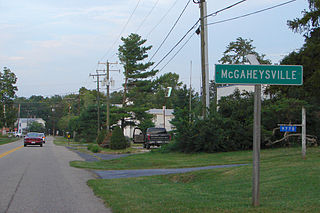
McGaheysville is a Census-designated place located in Rockingham County, in the U.S. state of Virginia. It is located along U.S. Route 33 between Penn Laird and Elkton, and sits at the base of the Massanutten.

Smithburg is an unincorporated community located where the municipal boundaries of Freehold, Manalapan and Millstone townships intersect in Monmouth County, in the U.S. state of New Jersey. County Route 527 and Monmouth Road pass through the center of the quaint village of Smithburg.

Hornerstown is an unincorporated community located within Upper Freehold Township in Monmouth County, in the U.S. state of New Jersey. Hornerstown is located near Cream Ridge and uses the 08514 ZIP code.

Rosemont is an unincorporated community located within Delaware Township in Hunterdon County, in the U.S. state of New Jersey. Its ZIP code is 08556. Located at the top of a small hill, the center of the community is located along Kingwood Stockton Road near its intersections with Raven Rock Rosemont Road and Rosemont Ringoes Road. Farmland and residences make up the surrounding area while the center of the settlement includes residences, a post office, and an antique shop.

Hoffman is an unincorporated community located within Monroe Township in Middlesex County, in the U.S. state of New Jersey. The settlement is located at the site of a former railroad station on the Freehold and Jamesburg Agricultural Railroad. Today, most of the area is made up of homes and housing developments along Hoffman Station Road and Gravel Hill-Spotswood Road. Forestland and the Manalapan Brook valley make up the remainder of the area.

Fresh Ponds is an unincorporated community located within South Brunswick Township in Middlesex County, in the U.S. state of New Jersey. It is located in a rural portion of the township at the intersection of Fresh Ponds Road and Davidson Mill Road. Forest land, farms, homes, and a church are located around the settlement.

Middlesex Downs is an unincorporated community located within Monroe Township in Middlesex County, in the U.S. state of New Jersey. The wholly residential settlement contains small homes along Dey Grove Road and Bergen Mills Road with larger homes in developments towards the south. The township-owned James Monroe Memorial Park is also located in this settlement. Much of the area to the north of Dey Grove Road consists of forest land but at one time this was planned to become a large planned community arranged in a street grid. The small property parcels and paper streets remain on township tax maps today.
Tracy is an unincorporated community located within Monroe Township in Middlesex County, in the U.S. state of New Jersey. The settlement is located at the site of a former station on the Freehold and Jamesburg Agricultural Railroad in the southeastern edge of the township. Most of the area is forestland with some homes and light commercial businesses located along Federal Road and Tracy Station Road.

Union Valley is an unincorporated community located within Monroe Township in Middlesex County, in the U.S. state of New Jersey. Two large age-restricted communities lie within the settlement today, Clearbrook and Concordia. Other than those two communities, the only other buildings in the area are medical offices and facilities and some single-family homes along Union Valley Road.

Wyckoffs Mills is an unincorporated community located along the border of Cranbury and Monroe townships in Middlesex County, in the U.S. state of New Jersey. Located at the intersection of Wyckoff Mills Road and Wyckoffs Mills Road, the area only contains lots containing residential structures; the remainder of the land is made up of farmland and wetlands. The Millstone River flows to the south of the settlement and a 500-kilovolt transmission line crosses the farmland to the north and south.

Oceanic is an unincorporated community located within Rumson in Monmouth County, in the U.S. state of New Jersey. Located on the north side of the borough, Oceanic contains most of Rumson's commercial businesses mainly along Bingham Avenue and River Road. Bingham Avenue connects directly to the Oceanic Bridge over the Navesink River to the Middletown Township community of Locust Point.

Spotswood is a borough in Middlesex County, in the U.S. state of New Jersey. The community is nestled within the heart of the Raritan Valley region, with the Manalapan Brook and Matchaponix Brook forming the confluence of the South River inside the borough. As of the 2020 United States census, the borough's population was 8,163, a decrease of 94 (−1.1%) from the 2010 census count of 8,257, which in turn reflected an increase of 377 (+4.8%) from the 7,880 counted in the 2000 census.

Stonytown Road is a 1.32-mile road in the incorporated villages of Flower Hill, Plandome, and Plandome Manor in the Town of North Hempstead, in Nassau County, on the North Shore of Long Island, in New York, United States. It serves as a major east-west through street across the Cow Neck Peninsula, between Plandome Road and North Plandome Road to the west and Port Washington Boulevard to the east – as well as forming portions of municipal boundaries.


