
Middlesex County is a county located in the north-central part of the U.S. state of New Jersey, extending inland from the Raritan Valley region to the northern portion of the Jersey Shore. As of the 2020 United States census, the county was the state's third-most populous county with a population of 863,162, its highest decennial count ever and an increase of 53,304 (+6.6%) from the 2010 census count of 809,858, which in turn reflected an increase of 59,696 (8.0%) from the 750,162 counted in the 2000 census. Middlesex is part of the New York metropolitan area. Many communities within the county serve as commuter towns to and from New York City and other points north. The county is part of the Central Jersey region of the state.

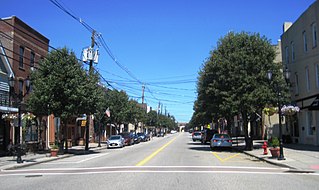
Sayreville is a borough in Middlesex County, in the U.S. state of New Jersey. Sayreville is within the heart of the Raritan Valley region, located on the south banks of the Raritan River, and also located on the Raritan Bay. As of the 2020 United States census, the borough's population was 45,345, an increase of 2,641 (+6.2%) from the 2010 census count of 42,704, which in turn reflected an increase of 2,327 (+5.8%) from the 40,377 counted in the 2000 census.
South Amboy is a suburban city in Middlesex County, in the U.S. state of New Jersey, located on Raritan Bay. As of the 2020 United States census, the city's population was 9,411, an increase of 780 (+9.0%) from the 2010 census count of 8,631, which in turn reflected an increase of 718 (+9.1%) from the 7,913 counted in the 2000 census.

The Raritan River is the longest and largest river of the U.S. state of New Jersey. Its watershed drains much of the mountainous area of the central region and a smaller portion of the northern region of the state, emptying into the Raritan Bay near Staten Island on the Atlantic Ocean.

Central Jersey, or Central New Jersey, is the middle region of the U.S. state of New Jersey. The designation Central Jersey is a distinct administrative toponym. While New Jersey is often divided into North Jersey and South Jersey, many residents recognize Central Jersey as a distinct third entity. As of the 2020 census, Central Jersey has a population of 3,580,999.

Keasbey is a census-designated place (CDP) and unincorporated community in Woodbridge Township, Middlesex County, New Jersey, United States. It is located in the western outskirts of adjacent Perth Amboy. As of the 2020 census, the CDP's population was 3,027. Many Hispanic / Latino families have relocated from Perth Amboy to Keasbey.

Sayreville War Memorial High School (SWMHS) is a four-year public high school located in the Parlin section of Sayreville, in Middlesex County, in the U.S. state of New Jersey, serving students in ninth through twelfth grades as the lone secondary school of the Sayreville Public Schools district. The school is home to the Sayreville Bombers, who are best known for their varsity football and track program. Sayreville's colors are blue and grey. The name "War Memorial" recognizes the World War II veterans who reside in the borough. The school has been accredited by the Middle States Association of Colleges and Schools Commission on Elementary and Secondary Schools since 1946.

Parlin is an unincorporated community located within Old Bridge Township and Sayreville Borough in Middlesex County, New Jersey, United States. The area is served as United States Postal Service ZIP Code 08859.

The T. A. Gillespie Company Shell Loading Plant explosion, sometimes called the Morgan Munitions Depot explosion or similar titles, began at 7:36 pm EDT on Friday, October 4, 1918, at a World War I ammunition plant in the Morgan area of Sayreville in Middlesex County, New Jersey, United States. The initial explosion, generally believed to be accidental, triggered a fire and subsequent series of explosions that continued for three days, totaling approximately six kilotons, killing about 100 people and injuring hundreds more. The facility, one of the largest in the world at the time, was destroyed along with more than 300 surrounding buildings, forcing the evacuation and reconstruction of Sayreville, South Amboy, and Laurence Harbor. Over a century later, explosive debris continues to surface regularly across a 1.2-mile (1.9 km) radius.
Nixon is an unincorporated community located within Edison Township in Middlesex County, in the U.S. state of New Jersey. It was named after Lewis Nixon, a manufacturer and community leader. Soon after the outbreak of World War I, Nixon established a massive volatile chemicals processing facility there, known as the Nixon Nitration Works. It was the site of the 1924 Nixon Nitration Works disaster, a massive explosion and resulting fire that killed 20 persons and destroyed several square miles around the plant.
Bonhamtown is a section of Edison Township in Middlesex County, New Jersey, United States.
Chrome is an unincorporated community located within Carteret in Middlesex County, in the U.S. state of New Jersey. The neighborhood's main street was once a bustling shopping district. The Chemical Coast rail line passes through the area.

Clara Barton is an unincorporated community located within Edison Township in Middlesex County, in the U.S. state of New Jersey. It takes its name from Clara Barton.
Melrose is a neighborhood in Sayreville in Middlesex County, New Jersey, United States. Melrose was consolidated with Ernston, Morgan, and Sayre's Village under one municipal government in 1876, when the newly formed Township of Sayreville was created from approximately 14 square miles (36 km2) of what was then South Amboy Township.

Pumptown is an unincorporated community located within Edison Township in Middlesex County, in the U.S. state of New Jersey.
Sayreville Station is a neighborhood in Sayreville in Middlesex County, in the U.S. state of New Jersey. Originally terminus of Raritan River Railroad's Sayreville Branch between Upper and Lower Sayreville. The spur was abandoned in 1978.
Morgan Draw is railroad moveable bridge over the Cheesequake Creek between the Morgan section of Sayreville and Laurence Harbor in Old Bridge in Middlesex County, New Jersey, United States. Located at MP 0.2 near the mouth on the Raritan Bay, the bascule bridge lies just upstream of the New Jersey Route 35 crossing. It is owned and operated by New Jersey Transit Rail Operations (NJT) and substantially rehabilitated in 2005-2008. A storm surge during Hurricane Sandy in 2012 caused severe damage to the bridge.

