Colonia is an unincorporated community and census-designated place (CDP) in Woodbridge Township, Middlesex County, New Jersey, United States. As of the 2020 United States census, the CDP's population was 18,609.

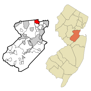
Edison is a township located in Middlesex County, in the U.S. state of New Jersey. Situated in Central New Jersey within the core of the state's Raritan Valley region, Edison is a commercial hub and is a bedroom community of New York City within the New York metropolitan area.

Iselin is an unincorporated community and census-designated place (CDP) located within Woodbridge Township, in Middlesex County, in the U.S. state of New Jersey. As of the 2020 United States census, Iselin's population was 20,088, up from 18,695 in 2010.

Metuchen is a suburban borough in Middlesex County in the U.S. state of New Jersey. The borough is a commuter town of New York City, located in the heart of the Raritan Valley region within the New York Metropolitan area. The borough, along with Edison, is a regional commercial hub for Central New Jersey. The borough is 6 miles (9.7 km) northeast of New Brunswick, 17 miles (27 km) southwest of Newark, 20 miles (32 km) southwest of Jersey City, and 22 miles (35 km) southwest of Manhattan. As of the 2020 United States census, the borough's population was 15,049, an increase of 1,475 (+10.9%) from the 2010 census count of 13,574, which in turn reflected an increase of 734 (+5.7%) from the 12,840 counted in the 2000 census.

Piscataway is a township in Middlesex County, in the U.S. state of New Jersey. It is a suburb of the New York metropolitan area, in the Raritan Valley. As of the 2020 United States census, the township's population was 60,804, an increase of 4,760 (+8.5%) from the 2010 census count of 56,044, which in turn reflected an increase of 5,562 (+11.0%) from 50,482 at the 2000 census.

North Brunswick is a township in Middlesex County, in the U.S. state of New Jersey. It is centrally located in the Raritan Valley region within the New York metropolitan area. As of the 2020 United States census, the township's population was 43,905, an increase of 3,163 (+7.8%) from the 2010 census count of 40,742, which in turn reflected an increase of 3,455 (+12.3%) from the 36,287 counted in the 2000 census.
Hopelawn is an unincorporated community and census-designated place (CDP) in Woodbridge Township, Middlesex County, New Jersey, United States. As of the 2020 United States census, the population of the CDP was 2,603.

The Stelton Baptist Church is in the Stelton section of Edison, Middlesex County, New Jersey. It is the second oldest Baptist Church in New Jersey and the tenth oldest in the United States.

Edison is a commuter railroad station in the Stelton section of Edison, Middlesex County, New Jersey, United States. Located at the intersection of Plainfield Avenue (CR 529) and Central Avenue, the station is served by New Jersey Transit's Northeast Corridor Line. Amtrak trains cross through but bypass the station. Edison station contains two side platforms, both high-level for handicap accessibility under the Americans with Disabilities Act of 1990 (accessible). The next station north, towards New York Penn Station is Metuchen while the next station south, with service towards Jersey Avenue station in New Brunswick and Trenton Transit Center is New Brunswick.
Bonhamtown is a section of Edison Township in Middlesex County, New Jersey, United States.

Penns Neck is an unincorporated community located within West Windsor Township in Mercer County, in the U.S. state of New Jersey. The community developed at the intersection of the Trenton-New Brunswick Turnpike and Washington Road. The Penns Neck Circle and the historic Penns Neck Baptist Church (1812) are both located in Penns Neck. The Princeton Branch rail line, known as the Dinky, has run through the area since 1865, and stopped at Penns Neck station until January 1971.

Clara Barton is an unincorporated community located within Edison Township in Middlesex County, in the U.S. state of New Jersey. It takes its name from Clara Barton.
Edgars or Edgar is an unincorporated community located within Woodbridge Township in Middlesex County, in the U.S. state of New Jersey. It approximately includes the area around Woodbridge High School over to Rahway Avenue, south of the Port Reading Railroad. The upper section of Ridgedale Avenue is known as Edgar's Hill. There was a Pennsylvania Railroad stop called Edgars approximately where Prospect Avenue would cross the railway, steps for this are still visible on the western side as of 2016.
New Dover is an unincorporated community located within Edison Township in Middlesex County, in the U.S. state of New Jersey. The neighborhood began as colonial village that was part of adjacent Woodbridge Township. Along with Bonhamtown, New Durham and Stelton, it is one of the older historical communities of the township.
New Durham was an unincorporated community and now a neighborhood located within Edison in Middlesex County, New Jersey, United States, south of Dismal Swamp.
Potters was an unincorporated community and is now a neighborhood within Edison Township in Middlesex County, in the U.S. state of New Jersey.
Palermo is an unincorporated community and census-designated place (CDP) located in Upper Township, in Cape May County, in the U.S. state of New Jersey.

Old Bridge, also known as the Historic Village of Old Bridge, is an unincorporated community located within East Brunswick in Middlesex County, in the U.S. state of New Jersey. It is on the South River, a tributary of the Raritan River. The community is named after the first bridge built here to cross the river, the South River Bridge. After other bridges were built crossing the river, it became known as the Old Bridge. The Old Bridge Historic District, encompassing much of the village, is listed on the state and national registers of historic places.

Piscatawaytown is the oldest neighborhood in Edison in Middlesex County, New Jersey. It was established in the 1660s as the original village in what was then within Piscataway. Piscatawaytown is centered around St. James Church, the Piscatawaytown Burial Ground and the Piscatawaytown Common, near the intersection of Plainfield and Woodbridge Avenues.