
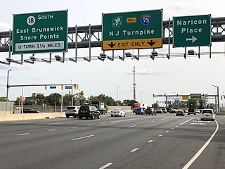
Route 18 is a 47.9-mile-long (77.1 km) state highway in the central part of the US state of New Jersey. It begins at an intersection with Route 138 in Wall Township, Monmouth County and ends at I-287 in Piscataway, Middlesex County. Route 18 is a major route through Central New Jersey that connects the Jersey Shore to the Raritan Valley region, connecting the county seats of Monmouth (Freehold) and Middlesex respectively. The route runs through Ocean Township, Marlboro, East Brunswick, and is the main thoroughfare for Rutgers University. Much of the route is a freeway. The remainder of the route is an arterial road with traffic lights in the East Brunswick and Old Bridge areas, and a boulevard in the remainder of Piscataway. Route 18 was designated in 1939 as a proposed freeway from Old Bridge to Eatontown. The section west of Old Bridge was formerly designated as part Route S28, a prefixed spur of State Highway Route 28 from Middlesex to Matawan. The designation, assigned in the 1927 renumbering, remained until a second renumbering in 1953. At that point, Route S28 was redesignated as Route 18, though the section from Old Bridge to Matawan was signed as TEMP 18, as this section would be decommissioned when the Route 18 freeway was built.

Middlesex County is a county located in the north-central part of the U.S. state of New Jersey, extending inland from the Raritan Valley region to the northern portion of the Jersey Shore. As of the 2020 United States census, the county was the state's third-most populous county with a population of 863,162, its highest decennial count ever and an increase of 53,304 (+6.6%) from the 2010 census count of 809,858, which in turn reflected an increase of 59,696 (8.0%) from the 750,162 counted in the 2000 census. Middlesex is part of the New York metropolitan area. Many communities within the county serve as commuter towns to and from New York City and other points north. The county is part of the Central Jersey region of the state.
East Brunswick is a township in Middlesex County, in the U.S. state of New Jersey. The suburban bedroom community is part of the New York City metropolitan area and is located on the southern shore of the Raritan River, directly adjacent to the city of New Brunswick and located roughly 29 miles (47 km) away from New York City. As of the 2020 United States census, the township's population was 49,715, its highest decennial count ever and an increase of 2,203 (+4.6%) from the 2010 census count of 47,512, which in turn reflected an increase of 756 (+1.6%) from the 46,756 counted in the 2000 census.
Highland Park is a borough in Middlesex County, in the U.S. state of New Jersey, in the New York City metropolitan area. The borough is located on the northern banks of the Raritan River, in the Raritan Valley region. As of the 2020 United States census, the borough's population was 15,072, an increase of 1,090 (+7.8%) from the 2010 census count of 13,982, which in turn reflected a decline of 17 (−0.1%) from the 13,999 counted in the 2000 census.

Piscataway is a township in Middlesex County, in the U.S. state of New Jersey. It is a suburb of the New York metropolitan area, in the Raritan Valley. As of the 2020 United States census, the township's population was 60,804, an increase of 4,760 (+8.5%) from the 2010 census count of 56,044, which in turn reflected an increase of 5,562 (+11.0%) from 50,482 at the 2000 census.

North Brunswick is a township in Middlesex County, in the U.S. state of New Jersey. It is centrally located in the Raritan Valley region within the New York metropolitan area. As of the 2020 United States census, the township's population was 43,905, an increase of 3,163 (+7.8%) from the 2010 census count of 40,742, which in turn reflected an increase of 3,455 (+12.3%) from the 36,287 counted in the 2000 census.

Central Jersey, or Central New Jersey, is the middle region of the U.S. state of New Jersey. The designation Central Jersey is a distinct administrative toponym. While New Jersey is often divided into North Jersey and South Jersey, many residents recognize Central Jersey as a distinct third entity. As of the 2020 census, Central Jersey has a population of 3,580,999.

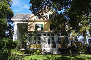
The Metlar House, also known as the Knapp House, the Bodine House, or the Metlar–Bodine House, is an historic house, now museum, located along River Road in Piscataway, New Jersey. It is also believed to be haunted. In 2003 a fire badly damaged the house. The museum has undergone major renovations over the past decade and, as of Summer 2014, is once again open to the public.

The Cornelius Low House is a Georgian manor in Piscataway, Middlesex County, New Jersey, United States, built in 1741 at Raritan Landing. The Cornelius Low House is listed on the New Jersey Register of Historic Places and National Register of Historic Places. The house currently holds the Cornelius Low House/Middlesex County Museum.

Landing Lane Bridge is part of County Route 609 and spans the Raritan River and the Delaware and Raritan Canal in New Jersey. The two lane bridge connects Piscataway to the north with New Brunswick to the south. The approaching roadways on both sides are known as "Landing Lane." The Delaware and Raritan Canal State Park and towpath is accessible from the bridge.

The Road Up Raritan Historic District is a 69-acre (28 ha) historic district located along River Road in the township of Piscataway in Middlesex County, New Jersey. It is north of Raritan Landing, once an important inland port on the Raritan River during the 18th and 19th centuries. The name is taken from an earlier colonial era name for what was once a Lenape path, Assunpink Trail that became a main road parallel to the river. Piscataway Township itself was formed on December 18, 1666 as one of the first seven townships in East Jersey, and is one of the oldest municipalities in the state. It was added to the National Register of Historic Places on September 18, 1997, for its significance in architecture, military history, and exploration/settlement. The district includes nine of fourteen historic homes along an approximately 1.2-mile (1.9 km) stretch of River Road. The Metlar-Bodine House and the Cornelius Low House are also in the immediate vicinity.
The Matthias Smock House is a historic house located at 851 River Road in the township of Piscataway in Middlesex County, New Jersey, United States. It was documented by the Historic American Buildings Survey (HABS) in 1938. The house was added to the National Register of Historic Places on December 4, 1973, for its significance in architecture. It was listed as a contributing property of the Road Up Raritan Historic District in 1997.

The Isaac Onderdonk House, also known as the Walter C. and Julia Meuly House, is a historic house located at 685 River Road in the township of Piscataway in Middlesex County, New Jersey, United States. It was added to the National Register of Historic Places on October 30, 1973, for its significance in architecture. It was listed as a contributing property of the Road Up Raritan Historic District in 1997.

East Jersey Old Town Village is an open-air museum located in Johnson Park in Piscataway, New Jersey. The Village is a collection of Raritan Valley area historic buildings and includes original, reconstructed, and replicated 18th and 19th century vernacular architecture typical of farm and merchant communities of Central Jersey. It is home to a permanent exhibition about Raritan Landing, an 18th-century inland port once located just downstream on the river. Since 1989, the Middlesex County Office of Arts and History has had responsibility for the village.

The Old Stone Arch Bridge is a bridge located in Bound Brook, New Jersey, United States. It is the second-oldest extant bridge in the US, after the Frankford Avenue Bridge over Pennypack Creek in North Philadelphia, Pennsylvania. Built in 1731, it is the oldest bridge in New Jersey. It spans the Green Brook and connects Bound Brook with Middlesex Borough in northern central New Jersey.

Fieldville is a historical unincorporated community located within Piscataway Township in Middlesex County, in the U.S. state of New Jersey. The location is sometimes described as being on River Road south of Bound Brook. The community was named after John Field and his descendants who settled the area.
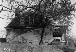
Ross Hall was a historic colonial farmhouse located on River Road in Piscataway, New Jersey. It was built c. 1739 by Edward Antill and is also known as the Edward Antill House. In 1768, it was purchased by its namesake, Dr. Alexander Ross.

Old Bridge, also known as the Historic Village of Old Bridge, is an unincorporated community located within East Brunswick in Middlesex County, in the U.S. state of New Jersey. It is on the South River, a tributary of the Raritan River. The community is named after the first bridge built here to cross the river, the South River Bridge. After other bridges were built crossing the river, it became known as the Old Bridge. The Old Bridge Historic District, encompassing much of the village, is listed on the state and national registers of historic places.

Piscatawaytown is the oldest neighborhood in Edison in Middlesex County, New Jersey. It was established in the 1660s as the original village in what was then within Piscataway. Piscatawaytown is centered around St. James Church, the Piscatawaytown Burial Ground and the Piscatawaytown Common, near the intersection of Plainfield and Woodbridge Avenues.


