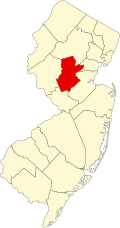
Six Mile Run, New Jersey | |
---|---|
Location in Somerset County Location in New Jersey | |
Coordinates: 40°28′12″N74°31′56″W / 40.469914°N 74.532222°W [1] [2] | |
Country | United States |
State | New Jersey |
County | Somerset |
Township | Franklin |
Area | |
• Total | 7.48 sq mi (19.38 km2) |
• Land | 7.47 sq mi (19.36 km2) |
• Water | 0.01 sq mi (0.02 km2) 0.10% |
Elevation | 98 ft (30 m) |
Population | |
• Total | 3,383 |
• Density | 452.58/sq mi (174.74/km2) |
Time zone | UTC−05:00 (Eastern (EST)) |
• Summer (DST) | UTC−04:00 (Eastern (EDT)) |
Area code(s) | 609/640 and 732/848 |
FIPS code | 34-67820 [1] [2] [6] |
GNIS feature ID | 02584028 [1] [2] |
Six Mile Run is an unincorporated community and census-designated place (CDP) located in Franklin Township, in Somerset County, in the U.S. state of New Jersey. [7] [8] [9] As of the 2010 United States Census, the CDP's population was 3,184. [10]
According to the United States Census Bureau, Six Mile Run had a total area of 7.484 square miles (19.383 km2), including 7.476 square miles (19.363 km2) of land and 0.008 square miles (0.020 km2) of water (0.10%). [1] [2]
Census | Pop. | Note | %± |
---|---|---|---|
2010 | 3,184 | — | |
2020 | 3,383 | 6.3% | |
Population sources: 2010 [10] [5] |
The 2010 United States census counted 3,184 people, 1,152 households, and 820 families in the CDP. The population density was 425.9 per square mile (164.4/km2). There were 1,218 housing units at an average density of 162.9 per square mile (62.9/km2). The racial makeup was 37.00% (1,178) White, 33.86% (1,078) Black or African American, 0.19% (6) Native American, 23.62% (752) Asian, 0.00% (0) Pacific Islander, 2.73% (87) from other races, and 2.61% (83) from two or more races. Hispanic or Latino of any race were 8.92% (284) of the population. [10]
Of the 1,152 households, 37.8% had children under the age of 18; 53.8% were married couples living together; 12.1% had a female householder with no husband present and 28.8% were non-families. Of all households, 22.7% were made up of individuals and 4.7% had someone living alone who was 65 years of age or older. The average household size was 2.76 and the average family size was 3.31. [10]
25.5% of the population were under the age of 18, 7.6% from 18 to 24, 31.2% from 25 to 44, 29.0% from 45 to 64, and 6.8% who were 65 years of age or older. The median age was 36.3 years. For every 100 females, the population had 93.2 males. For every 100 females ages 18 and older there were 90.4 males. [10]
Six Mile Run Historic District | |
Location | Franklin Township, New Jersey |
---|---|
Area | 64,450 acres (260.8 km2) |
NRHP reference No. | 95001191 |
Added to NRHP | October 25, 1995 |
The National Register of Historic Places defines the Six Mile Run Historic District as roughly bounded by Grouser Road, Amwell Road, Bennetts Lane, New Jersey Route 27, a diagonal line from the bridge at Six Mile Run to South Middlebush Road at Claremont, Butler Road and the Millstone River. It includes a portion of the Delaware and Raritan Canal and the Six Mile Run Canal House that are separately listed on the National Register. It contains 149 contributing buildings, 5 contributing sites and 44 contributing structures.
Examples of Six Mile Run Historic District contributing buildings are the three Meadows Foundation maintained properties listed here:
Six Mile Run is the historic name for an unincorporated community located within portions of North Brunswick Township and South Brunswick Township in Middlesex County and Franklin Township in Somerset County, in New Jersey. Route 27 (historically known as Old Road/King's Highway and once part of the Lincoln Highway system) bisects the village and serves as the dividing line between the two counties. [11] The name of the settlement was formally changed from Six Mile Run to Franklin Park on June 25, 1872. [12]
In 1710, a congregation of the Dutch Reformed Church (now the Reformed Church in America) formed the Six Mile Run Reformed Church. [13] [14] The first building was replaced by a new building in 1766 and was later replaced in 1817 by a third structure on the same site. The current building replaced the 1817 church that was destroyed by fire in 1879. The Frelinghuysen Memorial Chapel was added in 1907 and the Fellowship Hall was dedicated in 1958. [15]
The proposed Six Mile Run Reservoir Site is adjacent to the Delaware and Raritan Canal and included a large portion of the Six Mile Run Watershed in central Franklin Township. In 1970, the land for the reservoir was acquired by the State through the New Jersey Department of Environmental Protection, Division of Water Resources as a future reservoir and recreation area and included many of the properties later listed as contributing to the Six Mile National Register Historic District. The reservoir was never built, and in 1993 administration of the area was transferred to the Division of Parks and Forestry. [16]
Today the Six Mile Run Reservoir site is maintained as a State Park and includes several trails that are used primarily by mountain bikers, hikers, and horseback riders. It has 8 miles (13 km) of twisting single track maintained by JORBA. Access to the park can be found at the large parking lot on Canal Road near Six Mile Run Road, from the parking lot of the private soccer club on Route 27, and from several smaller parking areas on roads that traverse the park. [17] [16]
Because part of the land at the site was taken out of cultivation 39 years ago, the process of "old field succession" has now yielded up trees and foliage that are unique among state park lands. In the section between Canal Road and South Middlebush Road, there are postings describing the foliage and the natural process. The "Red Dot" hiking trail, which runs between Canal Road and South Middlebush Road, has now been extended from South Middlebush Road up to NJ Route 27. There is a new White Trail, not fully blazed but very usable, running from a left fork off Red Dot near South Middlebush Road, to a parking lot off Jacques Lane.
Somerset County is a county located in the north-central part of the U.S. state of New Jersey. As of the 2020 census, the county was the state's 13th-most-populous county, with a population of 345,361, its highest decennial count ever and an increase of 21,917 (+6.8%) from the 2010 census count of 323,444. Somerset County constitutes part of the New York metropolitan area. Its county seat is Somerville. The most populous place in the county was Franklin Township, with 68,364 residents at the time of the 2020 census, while Hillsborough Township, with 55.00 square miles (142.4 km2), covered the largest total area of any municipality.
Kingston is an unincorporated community and census designated place (CDP) along the border of South Brunswick Township in Middlesex County and Franklin Township in Somerset County, and also located relatively near Princeton in Mercer County in the U.S. state of New Jersey. The historic settlement is in the Raritan Valley region, located along the course of the Millstone River. As of the 2010 United States Census, the CDP's population was 1,493, of which 1,222 were in South Brunswick Township and 271 in Franklin Township.
Bridgewater Township is a township in Somerset County in the U.S. state of New Jersey, located within the heart of the Raritan Valley region. Situated within Central New Jersey and crisscrossed by several major highways, the township is known for being both the regional commercial hub for Somerset County and as a suburban bedroom community of New York City within the New York Metropolitan Area. The township is located roughly 32 miles (51 km) away from Manhattan and about 20 miles (32 km) away from Staten Island.
Franklin Township is a township in Somerset County, in the U.S. state of New Jersey. It is centrally located in the Raritan Valley region, within the New York Metropolitan Area. As of the 2020 United States census, the township's population was 68,364, an increase of 6,064 (+9.7%) from the 2010 census count of 62,300, which in turn reflected an increase of 11,397 (+22.4%) from the 50,903 counted in the 2000 census. The township was the state's 19th most-populous municipality in 2020, after being ranked 22nd in 2010.
Blackwells Mills is an unincorporated community and census-designated place (CDP) located in Franklin Township in Somerset County, in the U.S. state of New Jersey. As of the 2010 U.S. census, the CDP's population was 803.
Martinsville is an unincorporated community and census-designated place (CDP) located within Bridgewater Township, in Somerset County, in the U.S. state of New Jersey. As of the 2010 United States Census, the CDP's population was 11,980.
Zarephath is an unincorporated community and census-designated place (CDP) and located in Franklin Township, in Somerset County, in the U.S. state of New Jersey, about 15 mi (24 km) north of Princeton. As of the 2020 United States census, the CDP's population was 69, an increase of 32 (+86.5%) from the 37 enumerated at the 2010 census.
The Six Mile Run Reservoir Site, part of the Delaware and Raritan Canal State Park, is located in Franklin Township, Somerset County, New Jersey, United States. It is adjacent to the Delaware and Raritan Canal. It covers 3,037 acres (12.29 km2). The reservoir plan was to flood the Six Mile Run watershed. The Six Mile Run is a tributary of the Millstone River that, with its tributaries, drains a large area in central Franklin Township, Somerset County, New Jersey and western portions of North Brunswick and South Brunswick Townships in Middlesex County, New Jersey. It derives its name, along with other streams, from the distance early surveyors estimated it was from the point where the historic King's Highway left the Raritan River at New Brunswick to the point the roadway crossed the stream. The estimates were not very accurate but the stream names have remained in use ever since.
Harlingen is an unincorporated community and census-designated place (CDP) located within Montgomery Township, in Somerset County, in the U.S. state of New Jersey. As of the 2010 United States Census, the CDP's population was 297.
Griggstown is an unincorporated community and census-designated place (CDP) located within Franklin Township, in Somerset County, in the U.S. state of New Jersey. As of the 2010 United States Census, the CDP's population was 819. The area was first settled around 1733.
Middlebush is an unincorporated community and census-designated place (CDP) located in Franklin Township, in Somerset County, in the U.S. state of New Jersey. As of the 2010 United States Census, the CDP's population was 2,326. It is perhaps most distinguished as being the host section for Franklin Township's municipal complex.
East Millstone is an unincorporated community and census-designated place (CDP) located in Franklin Township in Somerset County, in the U.S. state of New Jersey.
Franklin Park is an unincorporated community and census-designated place (CDP) located within Franklin Township, in Somerset County, in the U.S. state of New Jersey. As of the 2010 United States Census, the CDP's population was 13,295. Route 27 bisects the village and serves as the dividing line between the two counties. The adjacent sections of South Brunswick and North Brunswick, Middlesex County on the east side of Route 27 are also known as Franklin Park, but are not included within the CDP's boundaries.
Pleasant Plains is an unincorporated community and census-designated place (CDP) located in Franklin Township, in Somerset County, in the U.S. state of New Jersey. As of the 2010 United States Census, the CDP's population was 922. Having no distinct boundaries, a large area in the center of Franklin Township centered on the intersections of South Middlebush Road with Claremont and Suydam Roads is generally considered Pleasant Plains.
Weston is an unincorporated community and census-designated place (CDP) located in Franklin Township, in Somerset County, in the U.S. state of New Jersey. As of the 2010 United States Census, the CDP's population was 1,235.
Six Mile Run is a tributary of the Millstone River that drains a large area in central Franklin Township in Somerset County and as well western portions of North Brunswick and South Brunswick Townships in Middlesex County, New Jersey in the United States.
The Middlebush Village Historic District is a historic district located in the Village of Middlebush, an unincorporated community within Franklin Township, Somerset County, New Jersey. The district was added to the National Register of Historic Places on April 24, 2007. It includes 37 contributing buildings and three contributing sites.
Colonial Farms, also known as the Voorhees House, is located at 1719 Amwell Road in the Middlebush section of Franklin Township, Somerset County, New Jersey, United States. It was built in 1793 by P. Metz in a Georgian style. It is part of the Middlebush Village Historic District. The oldest building in the district, it was used in 1834 to organized the Middlebush Reformed Church. The location also includes a contributing large, red shingle, 19th-century Dutch barn. It is now the Stage House Tavern.
Finderne is an unincorporated community and census-designated place (CDP) located within Bridgewater Township, in Somerset County, in the U.S. state of New Jersey. As of the 2010 United States Census, the CDP's population was 5,600.
Ten Mile Run is an unincorporated community and census-designated place (CDP) located in Franklin Township, in Somerset County, in the U.S. state of New Jersey. As of the 2010 United States Census, the CDP's population was 1,959.