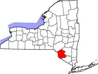
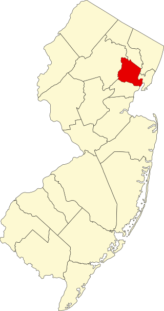
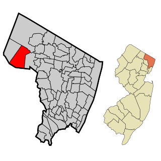
List of the National Register of Historic Places listings in Hudson County, New Jersey
Contents
| Atlantic – Bergen (Closter, Franklin Lakes, Ridgewood, Saddle River, Wyckoff) – Burlington – Camden – Cape May – Cumberland – Essex – Gloucester – Hudson – Hunterdon – Mercer – Middlesex – Monmouth – Morris – Ocean – Passaic – Salem – Somerset – Sussex – Union – Warren |
This is intended to be a complete list of properties and districts listed on the National Register of Historic Places in Hudson County, New Jersey. Latitude and longitude coordinates of the sites listed on this page may be displayed in an online map. [1]
The steam yacht Kestrel, originally listed in Hudson, has subsequently been moved to Upstate New York, while the ferry Yankee, originally listed in New York City was moored in Hoboken for a time; it is now moored in Brooklyn.
This National Park Service list is complete through NPS recent listings posted March 8, 2024. [2]
| [3] | Name on the Register [4] | Image | Date listed [5] | Location | City or town | Description |
|---|---|---|---|---|---|---|
| 1 | Association of Exempt Firemen Building |  | March 30, 1984 (#84002678) | 213 Bloomfield St. 40°44′22″N74°02′01″W / 40.739444°N 74.033611°W | Hoboken | Hoboken Firefighters Museum; part of the Hoboken Firehouses and Firemen's Monument Thematic Resource (TR) |
| 2 | Dr. William Barrow Mansion |  | May 2, 1977 (#77000872) | 83 Wayne St. 40°43′12″N74°02′56″W / 40.72°N 74.048889°W | Jersey City | |
| 3 | Bayonne Truck House No. 1 |  | January 2, 1976 (#76001155) | 12 W. 47th St. 40°40′51″N74°06′18″W / 40.680833°N 74.105°W | Bayonne | Bayonne Firefighters Museum |
| 4 | Bayonne Trust Company | 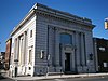 | August 8, 2006 (#06000693) | 229–231 Broadway 40°39′25″N74°07′35″W / 40.656944°N 74.126389°W | Bayonne | Bayonne Community Museum |
| 5 | Buildings at 1200–1206 Washington Street |  | March 9, 1987 (#87000350) | 1200–1206 Washington St. 40°44′57″N74°01′38″W / 40.749167°N 74.027222°W | Hoboken | aka The Yellow Flats |
| 6 | Church of Our Lady of Grace | 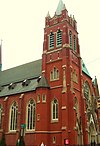 | May 31, 1996 (#96000550) | 400 Willow Ave. 40°44′32″N74°02′03″W / 40.742222°N 74.034167°W | Hoboken | |
| 7 | Church of the Holy Innocents |  | May 24, 1977 (#77000871) | Willow Ave. and 6th St. 40°44′38″N74°02′01″W / 40.743889°N 74.033611°W | Hoboken | |
| 8 | Clark Thread Company Historic District |  | June 2, 1978 (#78001764) | 900 Passaic Ave. 40°45′07″N74°09′45″W / 40.751944°N 74.1625°W | East Newark | |
| 9 | Engine Company No. 2 |  | March 30, 1984 (#84002684) | 1313 Washington St. 40°45′09″N74°01′36″W / 40.7525°N 74.026667°W | Hoboken | part of the Hoboken Firehouses and Firemen's Monument TR |
| 10 | Engine Company No. 3 |  | March 30, 1984 (#84002687) | 201 Jefferson St. 40°44′27″N74°02′17″W / 40.740833°N 74.038056°W | Hoboken | part of the Hoboken Firehouses and Firemen's Monument TR |
| 11 | Engine Company No. 4 |  | March 30, 1984 (#84002691) | 212 Park Ave. 40°44′23″N74°02′01″W / 40.739722°N 74.033611°W | Hoboken | part of the Hoboken Firehouses and Firemen's Monument TR |
| 12 | Engine Company No. 5 | 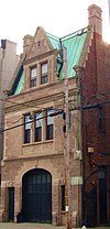 | March 30, 1984 (#84002693) | 412 Grand St. 40°44′33″N74°02′10″W / 40.7425°N 74.036111°W | Hoboken | part of the Hoboken Firehouses and Firemen's Monument TR |
| 13 | Engine Company No. 6 |  | March 30, 1984 (#84002695) | 801 Clinton St. 40°44′47″N74°02′01″W / 40.746389°N 74.033611°W | Hoboken | part of the Hoboken Firehouses and Firemen's Monument TR |
| 14 | Engine House No. 3, Truck No. 2 |  | March 30, 1984 (#84002700) | 501 Observer Hwy. 40°44′11″N74°02′26″W / 40.736389°N 74.040556°W | Hoboken | part of the Hoboken Firehouses and Firemen's Monument TR |
| 15 | Erie-Lackawanna Railroad Terminal at Hoboken |  | July 24, 1973 (#73001102) | On the Hudson River at the foot of Hudson Pl. 40°44′05″N74°01′27″W / 40.734722°N 74.024167°W | Hoboken | |
| 16 | Excelsior Engine Co. No. 2 Firehouse – Exempt Firemen Association Headquarters |  | August 12, 2022 (#100007991) | 6106 Polk Street 40°47′28″N74°01′02″W / 40.79103°N 74.0173°W | West New York | Exempt Firemen Association Headquarters |
| 17 | Fairmount Apartments |  | March 3, 1995 (#95000183) | 2595 Kennedy Blvd. 40°43′30″N74°04′27″W / 40.725°N 74.074167°W | Jersey City | |
| 18 | Ficken's Warehouse | 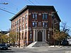 | June 14, 1984 (#84002703) | 750–766 Grand St. 40°42′55″N74°04′12″W / 40.715278°N 74.07°W | Jersey City | |
| 19 | Firemen's Monument |  | October 30, 1986 (#86003454) | Church Square Pk. 40°44′31″N74°01′56″W / 40.741944°N 74.032222°W | Hoboken | part of the Hoboken Firehouses and Firemen's Monument TR |
| 20 | First Baptist Church | 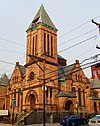 | February 1, 2006 (#05001570) | 901–907 Bloomfield St. 40°44′58″N74°01′43″W / 40.749444°N 74.028611°W | Hoboken | |
| 21 | First Reformed Dutch Church of Bergen Neck | 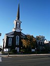 | April 22, 1982 (#82003274) | Avenue C and 33rd St. 40°40′25″N74°06′52″W / 40.673611°N 74.114444°W | Bayonne | |
| 22 | Grace Church Van Vorst | 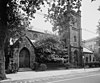 | August 1, 1979 (#79001492) | 268 2nd St 40°43′21″N74°02′42″W / 40.7225°N 74.045°W | Jersey City | |
| 23 | Great Atlantic and Pacific Tea Company Warehouse | 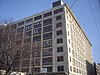 | June 2, 1978 (#78001766) | Provost St. between 1st and Bay Sts. 40°43′16″N74°02′25″W / 40.721111°N 74.040278°W | Jersey City | |
| 24 | Hackensack Water Company Complex |  | January 3, 1980 (#80002491) | 4100 Park Ave. 40°46′24″N74°01′13″W / 40.773333°N 74.020278°W | Weehawken | |
| 25 | Hale-Whitney Mansion |  | June 7, 1996 (#96000657) | 100 Broadway 40°38′56″N74°07′42″W / 40.648889°N 74.128333°W | Bayonne | |
| 26 | Hamilton Park Historic District |  | January 25, 1979 (#79001493) | Roughly bounded by Brunswick, Grove, 6th, and 9th Sts. • Boundary increase (listed December 2, 1982, refnum 82001044): Jersey Ave. and 10th St. 40°43′35″N74°02′45″W / 40.726389°N 74.045833°W | Jersey City | |
| 27 | Harsimus Cove Historic District | 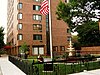 | December 9, 1987 (#87002118) | Roughly bounded by Grove Dr., Bay & First Sts., Jersey Ave., Second, & Coles Sts. 40°43′24″N74°02′41″W / 40.723333°N 74.044722°W | Jersey City | |
| 28 | Highland Hose No. 4 | 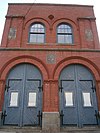 | May 29, 1987 (#87000856) | 72–74 Halstead St. 40°45′45″N74°09′03″W / 40.7625°N 74.150833°W | Kearny | |
| 29 | Hoboken City Hall | 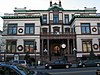 | January 1, 1976 (#76001156) | 86–98 Washington St. 40°44′14″N74°01′55″W / 40.737222°N 74.031944°W | Hoboken | |
| 30 | Hoboken Free Public Library and Manual Training School |  | August 4, 2015 (#14000535) | 500 Park Ave. 40°44′34″N74°01′56″W / 40.74290°N 74.03228°W | Hoboken | |
| 31 | Hoboken Land and Improvement Company Building | 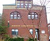 | July 3, 1979 (#79001491) | 1 Newark St. 40°44′10″N74°01′44″W / 40.736111°N 74.028889°W | Hoboken | |
| 32 | Holland Tunnel |  | November 4, 1993 (#93001619) | Connecting Lower Manhattan and Jersey City, running under the Hudson R. Coordinates missing | Jersey City | |
| 33 | Hook and Ladder No. 3 |  | August 24, 2015 (#15000049) | 218 Central Ave. 40°44′31″N74°03′07″W / 40.741999°N 74.051920°W | Jersey City | |
| 34 | Hudson and Manhattan Railroad Powerhouse | 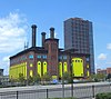 | November 23, 2001 (#01001256) | 60–84 Bay St., 344–56 Washington Blvd. 40°43′14″N74°02′10″W / 40.720556°N 74.036111°W | Jersey City | |
| 35 | Hudson County Courthouse |  | August 25, 1970 (#70000385) | Newark and Baldwin Aves. 40°43′53″N74°03′29″W / 40.731389°N 74.058056°W | Jersey City | |
| 36 | Jefferson Trust Company |  | February 13, 1986 (#86000214) | 313–315 First St. 40°44′15″N74°02′09″W / 40.7375°N 74.035833°W | Hoboken | |
| 37 | Jersey City Central Railroad Terminal |  | September 12, 1975 (#75001138) | U.S. 78 north of Ellis Island 40°42′30″N74°02′39″W / 40.708333°N 74.044167°W | Jersey City | |
| 38 | Jersey City High School |  | June 1, 1982 (#82003275) | 2 Palisade Ave. 40°43′48″N74°03′16″W / 40.73°N 74.054444°W | Jersey City | |
| 39 | Jersey City Medical Center |  | November 27, 1985 (#85003057) | Roughly bounded by Montgomery St., Cornelison Ave., Dupont St., Clifton Pl., and Baldwin Ave. 40°43′20″N74°03′51″W / 40.722222°N 74.064167°W | Jersey City | Renovation/restoration as residential/commercial mixed-use development, The Beacon |
| 40 | Jersey City YMCA | 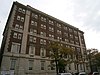 | November 12, 1999 (#99001314) | 654 Bergen Ave. 40°43′17″N74°04′19″W / 40.721389°N 74.071944°W | Jersey City | |
| 41 | Keuffel and Esser Manufacturing Complex | 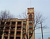 | September 12, 1985 (#85002183) | 3rd, Grand & Adams St. 40°44′29″N74°02′13″W / 40.741389°N 74.036944°W | Hoboken | Now residences known as Clock Towers |
| 42 | Labor Bank Building |  | June 14, 1984 (#84002705) | 26 Journal Sq. 40°43′49″N74°03′50″W / 40.730278°N 74.063889°W | Jersey City | |
| 43 | Lembeck and Betz Eagle Brewing Company District | 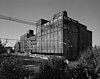 | June 21, 1984 (#84002707) | Bounded by 9th, 10th, Grove and Henderson StS. 40°43′42″N74°02′29″W / 40.728333°N 74.041389°W | Jersey City | The brewery buildings were demolished in 1997. |
| 44 | Loew's Jersey Theatre |  | April 25, 2022 (#100007648) | 54 Journal Sq. 40°43′56″N74°03′52″W / 40.7322°N 74.0645°W | Jersey City | |
| 45 | Monastery and Church of Saint Michael the Archangel |  | March 6, 1986 (#86000418) | 2019 West St. 40°45′56″N74°02′14″W / 40.765556°N 74.037222°W | Union City | |
| 46 | Morris Canal |  | October 1, 1974 (#74002228) | Irregular line beginning at Phillipsburg and ending at Jersey City Coordinates missing | Not applicable | |
| 47 | Morton Memorial Laboratory of Chemistry |  | April 25, 2022 (#100007647) | 6th and River Sts. (Stevens Institute of Technology) 40°44′35″N74°01′37″W / 40.74308°N 74.0269°W | Hoboken | |
| 48 | Old Bergen Church |  | August 14, 1973 (#73001103) | Bergen and Highland Aves. 40°43′37″N74°04′10″W / 40.726944°N 74.069444°W | Jersey City | |
| 49 | Paulus Hook Historic District | 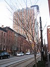 | June 21, 1982 (#82003276) | Greene, Washington, Grand, Sussex, Morris, Essex, Warren and York Sts. • Boundary increase (listed May 13, 1985, refnum 85002450): Roughly bounded by York, Green, Essex and Henderson 40°42′55″N74°02′21″W / 40.715278°N 74.039167°W | Jersey City | |
| 50 | Pohlmann's Hall | 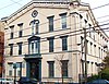 | September 5, 1985 (#85002001) | 154 Ogden Ave. 40°44′23″N74°02′45″W / 40.739722°N 74.045833°W | Jersey City | |
| 51 | Reservoir No. 3 |  | August 27, 2012 (#12000569) | Bounded by Summit, Jefferson, Central & Reservoir Aves. 40°44′25″N74°03′18″W / 40.740307°N 74.054956°W | Jersey City | |
| 52 | Robbins Reef Light Station | 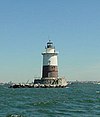 | July 19, 2006 (#06000631) | Southwest Upper New York Bay, 2.6 miles (4.2 km) southeast of I-78 Interchange 14A 40°39′26″N74°03′56″W / 40.657222°N 74.065556°W | Bayonne | |
| 53 | Route 1 Extension | 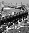 | August 12, 2005 (#05000880) | US 1 and 9 milepoint: 51.25-54.55, NJ 139 milepoint 0-1.45 40°44′09″N74°05′30″W / 40.73583°N 74.09167°W | Jersey City and Kearny | Includes Pulaski Skyway. Also listed in Essex County section. |
| 54 | Saint Ann Roman Catholic Church and Rectory |  | November 24, 2015 (#15000817) | 704 Jefferson Street 40°44′46″N74°02′10″W / 40.746226°N 74.036196°W | Hoboken | |
| 55 | St. Anthony of Padua Roman Catholic Church |  | March 22, 2004 (#04000225) | 457 Monmouth St. 40°43′41″N74°02′57″W / 40.728056°N 74.049167°W | Jersey City | |
| 56 | St. Patrick's Parish and Buildings | 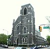 | September 17, 1980 (#80002489) | Grand St., Ocean and Bramhall Aves. 40°42′50″N74°04′23″W / 40.713889°N 74.073056°W | Jersey City | |
| 57 | St. Vincent de Paul Roman Catholic Church | 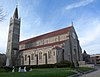 | August 24, 2011 (#11000590) | 979 Ave. C 40°40′55″N74°06′24″W / 40.681944°N 74.106667°W | Bayonne | |
| 58 | Statue of Liberty National Monument, Ellis Island and Liberty Island |  | October 15, 1966 (#66000058) | Upper New York Bay 40°41′38″N74°02′37″W / 40.693889°N 74.043611°W | Jersey City | |
| 59 | Edwin A. Stevens Hall | 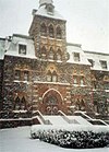 | February 4, 1994 (#94000009) | Fifth St. between Hudson and River Sts. 40°44′32″N74°01′41″W / 40.742222°N 74.028056°W | Hoboken | |
| 60 | United Synagogue of Hoboken |  | June 27, 2008 (#08000563) | 115–117 Park Ave 40°44′17″N74°02′01″W / 40.738104°N 74.033496°W | Hoboken | |
| 61 | Van Vorst Park Historic District |  | March 5, 1980 (#80002490) | Roughly bounded by Railroad Ave., Henderson, Grand, Bright, and Monmouth Sts. • Boundary increase (listed October 11, 1984, refnum 84000084): Roughly bounded by Railroad Ave., Henderson, Bright, Varick and Monmouth Sts. 40°43′07″N74°02′50″W / 40.718611°N 74.047222°W | Jersey City | |
| 62 | Van Wagenen House | 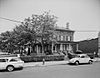 | August 16, 2006 (#05000884) | 298 Academy St. 40°43′49″N74°03′58″W / 40.730259°N 74.066242°W | Jersey City | |
| 63 | William Hall Walker Gymnasium | 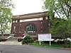 | May 9, 2019 (#100003907) | 6th St. at Fieldhouse Rd., Castle Point on Hudson 40°44′35″N74°01′35″W / 40.7430°N 74.0264°W | Hoboken | |
| 64 | West Bergen-East Lincoln Park Historic District | 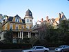 | July 19, 2016 (#15000050) | Roughly bounded by Bergen, Harrison, West Side, Kensington & Fairmount Aves., Kennedy Blvd. & Montgomery St. 40°43′13″N74°04′19″W / 40.720326°N 74.072016°W | Jersey City |