South Branch is an unincorporated community located within Hillsborough Township in Somerset County, New Jersey, United States. The community is named for and is located along the South Branch Raritan River. The South Branch Historic District encompassing the village was listed on the state and national registers of historic places in 1977.

Raven Rock is an unincorporated community and hamlet along the Delaware River approximately three miles (4.8 km) north of Stockton along New Jersey Route 29. The hamlet was known earlier as Saxtonville. It is located within Delaware Township in Hunterdon County, New Jersey, United States. It is the site of Bull's Island Recreation Area. The rock outcrop for which it is named is the southwest corner of the Hunterdon Plateau.

Pittstown is an unincorporated community located at the intersection of the boundaries of Alexandria, Franklin and Union townships in Hunterdon County, New Jersey. The area is named after William Pitt. The area is served as United States Postal Service ZIP Code 08867. The area was named Hofftown in the 18th century after landowner Lawrence Hoff. The Pittstown Historic District was listed on the state and national registers of historic places in 1990.

Millington is an unincorporated community located within Long Hill Township in Morris County, New Jersey, United States.

Mercerville is an unincorporated community and census-designated place (CDP) located within Hamilton Township, in Mercer County, New Jersey, United States. As of the 2010 United States Census, the CDP's population was 13,230. Until after the 2000 Census, the area was part of the Mercerville-Hamilton Square CDP. For the 2010 Census it was split into two CDPs, Mercerville and Hamilton Square.

Rutherford is a New Jersey Transit railroad station served by the Bergen County Line. The station straddles the border between Rutherford and East Rutherford in Bergen County, New Jersey, United States. The station building and Hoboken Terminal-bound platform is located near a traffic circle at the junction of Park Avenue, Union Avenue, Erie Avenue and Orient Way known as Station Square, with a grade crossing on Park Avenue. The tracks serve as the border between the two municipalities and the Suffern-bound platform and a small parking lot on the same side are actually located in East Rutherford; only the Hoboken-bound platform and a larger commuter lot are located on the Rutherford side.

Heislerville is an unincorporated community and census-designated place (CDP) that is part of Maurice River Township in Cumberland County in the U.S. state of New Jersey. It was named after the Heisler family, prominent members of the Methodist Episcopal Church established here in 1828.

Brookside is a historic unincorporated community within Mendham Township in Morris County, New Jersey, United States. It is located approximately 6 mi (9.7 km) west of Morristown. It is close to the Washington Valley Historic District in neighboring Morris Township.

Liberty Corner is an unincorporated community located in Bernards Township, in Somerset County, New Jersey. Liberty Corner is about 3.75 miles (6 km) south of Bernardsville. Liberty Corner has a post office with ZIP code 07938. The Liberty Corner Historic District was listed on the state and national registers of historic places in 1991.

Holmdel Dutch Reformed Church is a historic church at 41 Main Street in Holmdel Township, Monmouth County, New Jersey, United States.

Van Riper–Hopper House is located in Wayne, Passaic County, New Jersey, United States. The house was built in 1786 and was added to the National Register of Historic Places on August 21, 1972. The house is home to the Wayne Township Museum.

Smithburg is an unincorporated community located where the municipal boundaries of Freehold, Manalapan and Millstone townships intersect in Monmouth County, New Jersey, United States. County Route 527 and Monmouth Road pass through the center of the quaint village of Smithburg.

Arneytown is an unincorporated community located along Province Line Road on the border of North Hanover Township in Burlington County and Upper Freehold Township in Monmouth County of New Jersey. It is two miles (3.2 km) north of Jacobstown. Province Line Road was on the boundary line between the Provinces of East Jersey and West Jersey. The area was once called Upper Freehold by 18th-century Quaker settlers. With the establishment of the first post office in 1827, it became known as Arneytown.
Montrose is an unincorporated community located near the intersection of Dutch Lane Road and Boundary Road along the border of Colts Neck and Marlboro townships in Monmouth County, New Jersey, United States. The town was located in "Atlantic Township" at one time prior to the name being changed to "Colts Neck". Prior to being called Montrose, the area was called "Barrentown".

Rosemont is an unincorporated community located within Delaware Township in Hunterdon County, in the U.S. state of New Jersey. Its ZIP code is 08556. Located at the top of a small hill, the center of the community is located along Kingwood Stockton Road near its intersections with Raven Rock Rosemont Road and Rosemont Ringoes Road. Farmland and residences make up the surrounding area while the center of the settlement includes residences, a post office, and an antique shop.

Readingsburg, also known as Stone Mill, is an unincorporated community located along the South Branch Raritan River within Clinton Township in Hunterdon County, New Jersey.
Zion is an unincorporated community along the border of Hillsborough Township and Montgomery Township in Somerset County, New Jersey, United States. It is located on Rock Brook, approximately 3 mi (4.8 km) north of Hopewell.

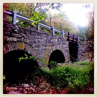
Rockefellows Mills is an unincorporated community located within Raritan Township in Hunterdon County, New Jersey, United States. The settlement is located along the South Branch Raritan River near Three Bridges. The river is spanned in the area by the historic Rockafellows Mill Bridge built in 1900 and part of the Raritan–Readington South Branch Historic District. Most of the area within the Raritan Township side of the river is forested however on the north side of the river in Readington Township, some farmland dots the area.

The Kingston Mill Historic District is a 49-acre (20 ha) historic district in Kingston, New Jersey. It is roughly bounded by Herrontown, River, and Princeton-Kingston Roads in the townships of Princeton in Mercer County, South Brunswick in Middlesex County, and Franklin in Somerset County. It was added to the National Register of Historic Places on April 10, 1986 for its significance in engineering, exploration/settlement, industry, and transportation. The district includes 16 contributing buildings and 2 contributing structures.

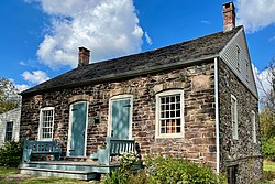
The Dirck Gulick House is a historic house built in 1752 and located at 506 County Route 601 in the Dutchtown section of Montgomery Township in Somerset County, New Jersey. The house was added to the National Register of Historic Places on December 11, 2003 for its significance in architecture and exploration/settlement. It is now operated as a historic house museum by the Van Harlingen Historical Society.