
Mercer County is a county located in the U.S. state of New Jersey. Its county seat is Trenton, also the state capital, prompting its nickname The Capital County. Mercer County alone constitutes the Trenton–Princeton metropolitan statistical area and is considered part of the New York combined statistical area by the U.S. Census Bureau, but also directly borders the Philadelphia metropolitan area and is included within the Federal Communications Commission's Philadelphia Designated Media Market Area. The county is part of the Central Jersey region of the state.

West Amwell Township is a township in Hunterdon County, in the U.S. state of New Jersey. As of the 2020 United States census, the township's population was 3,005, a decrease of 835 (−21.7%) from the 2010 census count of 3,840, which in turn reflected an increase of 1,457 (+61.1%) from the 2,383 counted in the 2000 census.

Ewing Township is a township in Mercer County, in the U.S. state of New Jersey. The township falls within the New York metropolitan area as defined by the U.S. Census Bureau. It borders the Philadelphia metropolitan area and is part of the Federal Communications Commission's Philadelphia Designated Market Area. As of the 2020 United States census, the township's population was 37,264, its highest decennial count ever and an increase of 1,474 (+4.1%) from the 35,790 recorded at the 2010 census, which in turn reflected an increase of 83 (+0.2%) from the 35,707 counted in the 2000 census.

Hopewell is a borough in Mercer County, in the U.S. state of New Jersey. Centrally located within the Raritan Valley region, this historical settlement is an exurban commuter suburb of New York City in the New York metropolitan area as defined by the United States Census Bureau. As of the 2020 United States census, the borough's population was 1,918, a decrease of 4 (−0.2%) from the 2010 census count of 1,922, which in turn had reflected a decline of 113 (−5.6%) from the 2,035 counted at the 2000 census.

Hopewell Township is a township in Mercer County, in the U.S. state of New Jersey. Located at the cross-roads between the Delaware Valley region to the southwest and the Raritan Valley region to the northeast, the township considered an exurb of New York City in the New York metropolitan area as defined by the United States Census Bureau, while also directly bordering the Philadelphia metropolitan area, being a part of the Federal Communications Commission's Philadelphia Designated Market Area. As of the 2020 United States census, the township's population was 17,491, its highest decennial count ever and an increase of 187 (+1.1%) from the 2010 census count of 17,304, which in turn reflected an increase of 1,199 (+7.4%) from the 16,105 counted in the 2000 census.

Lawrence Township is a township in Mercer County, in the U.S. state of New Jersey. Located at the cross-roads between the Delaware Valley region to the southwest and the Raritan Valley region to the northeast, the township is an outer-ring suburb of New York City in the New York Metropolitan area, as defined by the United States Census Bureau, while also directly bordering the Philadelphia metropolitan area and is part of the Federal Communications Commission's Philadelphia Designated Market Area.
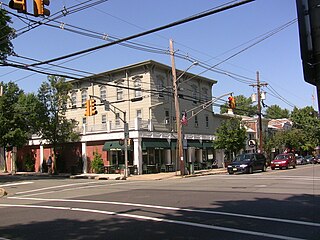
Pennington is a borough in Mercer County, in the U.S. state of New Jersey. The borough is located at the cross-roads between the Delaware Valley region to the southwest and the Raritan Valley region to the northeast. As of the 2020 United States census, the borough's population was 2,802, its highest decennial count ever and an increase of 217 (+8.4%) from the 2010 census count of 2,585, which in turn had reflected a decline of 111 (−4.1%) from the 2,696 counted in the 2000 census.

Princeton Township was a township in Mercer County, in the U.S. state of New Jersey, that existed from 1838 until the end of 2012. On January 1, 2013, it merged with the Borough of Princeton to form Princeton, New Jersey; both Princeton Township and the Borough of Princeton were dissolved in the merger.

Robbinsville Township is a township in Mercer County, in the U.S. state of New Jersey. It is located on the border of the New York metropolitan area and the Philadelphia metropolitan area. As of the 2020 United States census, the township's population was 15,476, its highest decennial count ever. Inspired by its central geographical location within New Jersey, Robbinsville's motto is Be at the Center of it All.

Montgomery Township is a township in southern Somerset County, in the U.S. state of New Jersey. It is located in the New York Metropolitan Area. As of the 2020 United States census, the township's population was 23,690, an increase of 1,436 (+6.5%) from the 2010 census count of 22,254, which in turn reflected an increase of 4,773 (+27.3%) from the 17,481 counted in the 2000 census.

Titusville is an unincorporated community and census-designated place (CDP) in Hopewell Township, Mercer County, in the U.S. state of New Jersey. As of the 2020 census, the population was 633. The area includes a post office with its own ZIP Code (08560), several restaurants, gas stations, a firehouse, and a small cluster of homes. Washington Crossing State Park, dedicated to George Washington's crossing of the Delaware River in 1776, is adjacent to the community.
New Jersey's 12th congressional district is represented by Democrat Bonnie Watson Coleman, who has served in Congress since 2015. The district is known for its research centers and educational institutions such as Princeton University, Rider University, The College of New Jersey, Institute for Advanced Study, Johnson & Johnson and Bristol-Myers Squibb. The district is primarily suburban in character, covering portions of Mercer, Somerset, Union, and Middlesex counties, although the district contains the state capital of Trenton as well as the smaller city of Plainfield.

County Route 518 is a county highway in the U.S. state of New Jersey. The highway extends 20.58 miles (33.12 km) from Route 29/Route 165 in Lambertville to Lincoln Highway in Franklin Township. It is also known as the Georgetown Franklin Turnpike.

The Sourlands is a region in the central portion of the U.S. state of New Jersey that includes portions of Hunterdon County, Mercer County, and Somerset County. It is centered on Sourland Mountain and comprises parts of Lambertville, East Amwell, West Amwell, Hillsborough, Hopewell Boro, Hopewell Township, and Montgomery Township. The region is flanked by the Hopewell Fault to the south and Amwell Valley to the north that runs from Mount Airy to an area just west of Flagtown and a diabase formation running from Lambertville to Mount Airy. The Sourland also include a hilly area towards the southwest called Pleasant Valley, with a number of farms. Although much of the Sourlands is not conducive to farming, Pleasant Valley and the slopes on the surrounding ridges have a number of farms. The slopes of the ridge to the north are also home to Unionville Vineyard.

Mount Rose is an unincorporated community located within Hopewell Township, in Mercer County, in the U.S. state of New Jersey, situated at the corner of Carter Road, Pennington-Rocky Hill Road, and Cherry Valley Road. It is named for a local gardener. The Mount Rose section of Rocky Hill Ridge through the community also takes its name from the gardener. Richard Stout opened the first general store in the village around 1822 and in 1830, Josiah Cook and Reuben Savidge opened a second store. The settlement was also later home to two shoe shops, a dressmaker, wheelwrights, a blacksmith, a harness shop, an agricultural implements warehouse, a post office and a steam sawmill. In its heyday the community had about 20 houses. Nathaniel Drake opened an applejack distillery in the village in the mid-19th century. He made and sold peach brandy, apple cider and apple whiskey. The Whiskey House, the office building for the distillery and the only remaining Drake building in the village, is listed on the township, state and national registers of historic places. The community's schoolhouse, a stone building east of the crossroads, was later replaced by a frame building on the southern end of the village that is a private residence today. After 1880, Mount Rose began shrinking, due to the growth of nearby Hopewell Borough. It is planned that the Lawrence Hopewell Trail will go through the community.

Harbourton is an unincorporated community located within Hopewell Township in Mercer County, in the U.S. state of New Jersey. It is located along County Route 579 at the intersection with Harbourton-Mount Airy Road. The Harbourton Historic District, encompassing the community, was listed on the state and national registers of historic places in 1974.
Marshalls Corner is an unincorporated community located within Hopewell Township in Mercer County, in the U.S. state of New Jersey and is centered about the intersection of Pennington-Hopewell Road and Woodsville-Marshalls Corner Road. The community has many residences, a Kooltronic manufacturing facility, and is the site of the vacant Pennytown Shopping Center. The proposed redevelopment of Pennytown as a housing complex is controversial to residents due to concerns about increased traffic and site drainage.
Washington Crossing is an unincorporated community and census-designated place (CDP) in Hopewell Township, Mercer County, New Jersey, in the United States. The CDP and surrounding Hopewell Township lie on the eastern flank of the Washington Crossing Bridge spanning the Delaware River. Washington Crossing State Park is located adjacent to the community in New Jersey, while across the river lies Washington Crossing Historic Park in Washington Crossing, Pennsylvania. As of the 2020 United States census, the CDP's population was 371.

Pleasant Valley is an unincorporated community located within Hopewell Township in Mercer County, in the U.S. state of New Jersey. The Howell Living History Farm, also known as the Joseph Phillips Farm, is located in the community.

The Joseph Stout House, also known as the Hunt House and the Weart–Hunt House, is a historic stone house built in 1752 and located on Province Line Road in the Stoutsburg section of Hopewell Township in Mercer County, New Jersey, United States. It was documented by the Historic American Buildings Survey (HABS) in 1937. The house was added to the National Register of Historic Places on October 29, 1974, for its significance in military and religion history.


