
East Windsor is a township in Mercer County, in the U.S. state of New Jersey. Located at the cross-roads between the Delaware Valley region to the southwest and the Raritan Valley region to the northeast, the township is an outer-ring suburb of New York City in the New York Metropolitan area, as defined by the United States Census Bureau, but directly borders the Philadelphia metropolitan area and is part of the Federal Communications Commission's Philadelphia Designated Market Area. Since East Windsor is situated at the confluence of several major highways that serve both the major cities of New York City and Philadelphia, and even the local commercial hubs of nearby Freehold, Princeton, and the state capital of Trenton, the community has been a longtime residential, commercial, and industrial hub in the heart of Central New Jersey.

West Windsor is a township in Mercer County, in the U.S. state of New Jersey. Located at the cross-roads between the Delaware Valley region to the southwest and the Raritan Valley region to the northeast, the township is considered to be an outer-ring suburb of New York City in the New York metropolitan area, as defined by the United States Census Bureau. As of the 2020 United States census, the township's population was 29,518, its highest decennial count ever and an increase of 2,353 (+8.7%) from the 27,165 recorded at the 2010 census, which in turn reflected an increase of 5,258 (+24.0%) from the 21,907 counted in the 2000 census.

Plainsboro Township is a township situated in southern Middlesex County, in the U.S. state of New Jersey. Centrally located in the Raritan Valley region, the township is an outer-ring suburb of New York City in the New York metropolitan area, even though it is slightly geographically closer to Center City, Philadelphia than to Midtown Manhattan. As of the 2020 United States census, the township's population was 24,084, its highest decennial count ever and an increase of 1,085 (+4.7%) from the 22,999 recorded at the 2010 census, which in turn reflected an increase of 2,784 (+13.8%) from the 20,215 counted in the 2000 census.

Fox Chapel is a borough in Allegheny County, Pennsylvania, United States. It is a suburb of Pittsburgh located 6 miles (10 km) northeast of downtown. The population was 5,343 as of the 2020 census. The borough continually garners national prominence and is home to many of the wealthiest and most powerful patriciate families in Pennsylvania.
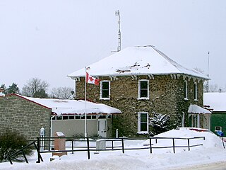
Elizabethtown-Kitley is a township in eastern Ontario, Canada, in the United Counties of Leeds and Grenville. Its southern border lies along the St. Lawrence River and it extends north into many rural hamlets and villages. The township was created on January 1, 2001, by the amalgamation of the former Township of Elizabethtown and Township of Kitley.

Clarksburg is an unincorporated community located within Millstone Township in Monmouth County, in the U.S. state of New Jersey. The area is served as United States Postal Service ZIP code 08510.

Rossville is a neighborhood of Staten Island, New York, on the island's South Shore. It is located to the north of Woodrow, to the west of Arden Heights, and to the south and east of the Arthur Kill. Rossville is located within Staten Island Community Board 3.

Edwardsburgh/Cardinal is a township in the United Counties of Leeds and Grenville of eastern Ontario, Canada. Edwardsburgh township was first surveyed in 1783, and incorporated in 1850. The township was part of the historical Grenville County before it merged with Leeds County to form the United Counties in the 19th century.

The West Windsor-Plainsboro Regional School District is a comprehensive high achieving regional public school district in the U.S. state of New Jersey, serving students in pre-kindergarten through twelfth grade from West Windsor Township and Plainsboro Township. There are four elementary schools, two upper elementary schools, two middle schools and two high schools. Niche.com listed the district as fourth best in New Jersey, and 63rd best in the nation, according to its 2023 Best Schools ranking.
Grovers Mill is an unincorporated community located within West Windsor in Mercer County, in the U.S. state of New Jersey. It is centered around the intersection of Clarksville Road and Cranbury Road, adjacent to the community's mill-pond.

Gildersome is a village and civil parish in the City of Leeds metropolitan borough 5 miles (7 km) south-west of Leeds city centre in West Yorkshire, England. Glidersome forms part of the Heavy Woollen District.

Maria Stein is a census-designated place in central Marion Township, Mercer County, Ohio, United States. The community and the Maria Stein Convent lie at the center of the area known as the Land of the Cross-Tipped Churches, where a missionary priest, Father Francis de Sales Brunner, established a number of parishes for German Catholics.
Mount Ulla Township is one of fourteen townships in Rowan County, North Carolina, United States. It is currently the smallest township in Rowan County by population.
Edinburg is a 1700s-era unincorporated community located within West Windsor in Mercer County, in the U.S. state of New Jersey. The community is located at the junction of Old Trenton Road, Edinburg Road, and Windsor Road.

Penns Neck is an unincorporated community located within West Windsor Township in Mercer County, in the U.S. state of New Jersey. The community developed at the intersection of the Trenton-New Brunswick Turnpike and Washington Road. The Penns Neck Circle and the historic Penns Neck Baptist Church (1812) are both located in Penns Neck. The Princeton Branch rail line, known as the Dinky, has run through the area since 1865, and stopped at Penns Neck station until January 1971.

Port Mercer is an unincorporated community located where the municipal boundaries of Lawrence Township, Princeton and West Windsor Township intersect in Mercer County, in the U.S. state of New Jersey. It is the location of the historic Port Mercer Canal House along the Delaware and Raritan Canal.

Berrien City, also known simply as Berrien, is an unincorporated community located within West Windsor in Mercer County, in the U.S. state of New Jersey. The neighborhood is located within the Princeton Junction census designated place centered about the intersection of Alexander Road and Scott Avenue, located within walking distance of the Princeton Junction train station and Princeton-Hightstown Road.

The Washington Road Elm Allée is a 0.7-mile-long (1.1 km) stretch of Washington Road in West Windsor, New Jersey that is lined with Princeton Elm trees. The allée runs through the West Windsor fields of Princeton University and provides, along with the bridge over Lake Carnegie, a dramatic entrance to the campus. The Delaware and Raritan Canal can be found at the northern end of the allée, just before the lake. A jogging path runs through the allée and connects to the canal towpath, the main campus of the university, and other trails through the adjacent fields.

Cool Springs Township is a non-functioning administrative division of Iredell County, North Carolina, United States. By the requirements of the North Carolina Constitution of 1868, the counties were divided into townships, which included Cool Springs township as one of sixteen townships in Iredell County.
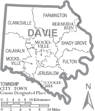
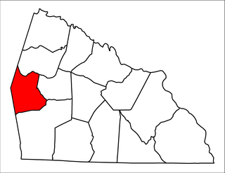
Calahaln Township is a non-functioning administrative division of Davie County, North Carolina, United States. By the requirements of the North Carolina Constitution of 1868, the counties were divided into townships, which included Calahaln township as one of sixteen townships in Davie County. Calahaln township is in western Davie County. The western border is the Iredell County line. The southern border is the South Yadkin River and Rowan County line. The northern and eastern borders are irregular and include portions of the Hunting Creek in on the southern end and Bear Creek on the northern end. The township was named for the Calahaln community, which was named for William Calahan or his descendants. William Calahan was in the area as early as 1778. Calahaln Mountain at 845 feet (258 m) is the highest point in Calahaln Township (35°55′32″N80°40′10″W.


