Route 18 is a 42.8-mile-long (68.9 km) state highway in the central part of the US state of New Jersey. It begins at an intersection with Route 138 in Wall Township, Monmouth County and ends at Interstate 287 (I-287) in Piscataway Township, Middlesex County. Route 18 is a major route through central New Jersey that connects the Jersey Shore to the Raritan Valley region, connecting the county seats of Monmouth (Freehold) and Middlesex respectively. The route runs through Ocean Township, Marlboro Township, and East Brunswick, as for much of the route is a freeway. The remainder of the route is an expressway with traffic lights in the East Brunswick and Old Bridge areas, and a boulevard in the remainder of Piscataway. Route 18 was designated in 1939 as a proposed freeway from Old Bridge to Eatontown. The section west of Old Bridge was formerly designated as part Route S28, a prefixed spur of State Highway Route 28 from Middlesex to Matawan. The designation, assigned in the 1927 renumbering, remained until a second renumbering in 1953. At that point, Route S28 was redesignated as Route 18, though the section from Old Bridge to Matawan was signed as TEMP 18, as this section would be decommissioned when the Route 18 freeway was built.

Route 12 is a state highway located in Hunterdon County, New Jersey, United States. It runs 11.69 mi (18.81 km) from the Uhlerstown–Frenchtown Bridge at the Delaware River border with Pennsylvania in Frenchtown east to an intersection with U.S. Route 202 and Route 31 at the Flemington Circle in Flemington. The route is mostly a two-lane undivided road that passes through rural areas of woodland and farmland. It intersects Route 29 and County Route 513 in Frenchtown, CR 519 in Kingwood Township, CR 579 on the border of Delaware Township and Raritan Township, and CR 523 in Raritan Township.

Route 29 is a state highway in the U.S. state of New Jersey. Signed north-south, it runs 34.76 mi (55.94 km) from an interchange with Interstate 295 (I-295) in Hamilton Township in Mercer County, where the road continues east as I-195, northwest to Route 12 in Frenchtown, Hunterdon County. Between the southern terminus and I-295 in Ewing Township, the route is a mix of freeway and expressway that runs along the Delaware River through Trenton. This section includes a truck-restricted tunnel that was built along the river near historic houses and Riverview Cemetery. North of I-295, Route 29 turns into a scenic and mostly two-lane highway. North of the South Trenton Tunnel, it is designated the Delaware River Scenic Byway, a New Jersey Scenic Byway and National Scenic Byway, that follows the Delaware River in mostly rural sections of Mercer County and Hunterdon County. The obsolete Delaware & Raritan Canal usually stands between the river and the highway. Most sections of this portion of Route 29 are completely shaded due to the tree canopy. Route 29 also has a spur, Route 129, which connects Route 29 to U.S. Route 1 (US 1) in Trenton.

Route 33 is a state highway in the central part of the US state of New Jersey. The highway extends 42.03 miles (67.64 km), from an interchange with U.S. Route 1 (US 1) in Trenton, Mercer County, east to an intersection with Route 71 in Neptune, Monmouth County. Route 33 is a major route through central New Jersey, as it runs from the greater state capital area in the Delaware Valley region, through a mixture of farmland, housing, and commercial developments in the lower Raritan Valley region, en route to the greater Asbury Park area on the Jersey Shore. The route traverses through historic towns such as Hightstown, Monroe, Manalapan, Freehold, and Tinton Falls. There are several intersections on Route 33 with future developments.

Ewing Township is a township in Mercer County, in the U.S. state of New Jersey. The township falls within the New York metropolitan area as defined by the U.S. Census Bureau. It borders the Philadelphia metropolitan area and is part of the Federal Communications Commission's Philadelphia Designated Market Area. As of the 2020 United States census, the township's population was 37,264, its highest decennial count ever and an increase of 1,474 (+4.1%) from the 35,790 recorded at the 2010 census, which in turn reflected an increase of 83 (+0.2%) from the 35,707 counted in the 2000 census.

Raritan River is a major river of New Jersey. Its watershed drains much of the mountainous area of the central part of the state, emptying into the Raritan Bay on the Atlantic Ocean.
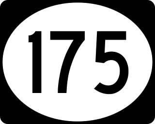
Route 175 is a short, 2.95-mile (4.75 km) long state highway in Mercer County, New Jersey, United States. The route runs along a former alignment of Route 29 before the construction of the John Fitch Parkway in the 1960s. The route begins at Route 29 in the capital city of Trenton, running along Sanhican Road, River Road, and West Upper Ferry Road into Ewing Township. The route serves primarily as a frontage road for Route 29. The northernmost portion of Route 175 is parallel to the Delaware and Raritan Canal until coming to an end at a merge with Route 29 in Ewing Township.
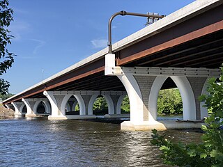
The Scudder Falls Bridge is a toll bridge that carries Interstate 295 (I-295) over the Delaware River, connecting Lower Makefield Township in Bucks County, Pennsylvania, with the Scudders Falls section of Ewing Township in Mercer County, New Jersey, United States. It is maintained by the Delaware River Joint Toll Bridge Commission (DRJTBC). The original bridge was a plate girder bridge constructed from 1958 to 1961, and the current structure is a box-girder bridge that opened in 2019. Previously, the bridge was a toll-free crossing. However, this changed on July 14, 2019, when an all-electronic toll was levied for Pennsylvania-bound traffic; the toll can be paid using E-ZPass or Toll-by-Plate.
The United New Jersey Railroad and Canal Company (UNJ&CC) was a United States-based railroad company established in 1872. It was formed by the consolidation of three existing companies: the Camden and Amboy Railroad, Delaware and Raritan Canal Company, and New Jersey Rail Road and Transportation Company. The Camden and Amboy and New Jersey Rail Road were among the earliest North American railroads. The Pennsylvania Railroad leased the United New Jersey Railroad and Canal Company in 1872.

Titusville is an unincorporated community and census-designated place (CDP) located within Hopewell Township in Mercer County, in the U.S. state of New Jersey. The area includes a post office with its own ZIP Code (08560), several restaurants, gas stations, a firehouse, and a small cluster of homes. The Washington Crossing State Park, dedicated to George Washington's crossing of the Delaware River in 1776, is adjacent to the community.
Pennsylvania Route 32 is a scenic two-lane highway that runs along the west side of the Delaware River in Bucks County, Pennsylvania. Signed north-south, it runs from U.S. Route 1 in Falls Township outside of Morrisville northwest to PA 611 in the village of Kintnersville in Nockamixon Township. PA 32 passes through Washington Crossing Historic Park, a Revolutionary War-themed historical park on the site of George Washington's crossing on the night of December 25–26, 1776. It also passes through the boroughs of Morrisville, Yardley, and New Hope.

County Route 579 is a county highway in the U.S. state of New Jersey. The highway extends 37.24 miles (59.93 km) from John Fitch Parkway in Trenton to Route 173 in Greenwich Township.

U.S. Route 9 (US 9) is a United States Numbered Highway in the Mid-Atlantic United States, running from Laurel, Delaware, north to Champlain, New York. In New Jersey, the route runs 166.80 miles (268.44 km) from the Cape May–Lewes Ferry terminal in North Cape May, Cape May County, where the ferry carries US 9 across the Delaware Bay to Lewes, Delaware, north to the George Washington Bridge in Fort Lee, Bergen County, where the route along with Interstate 95 (I-95) and US 1 continue into New York City. US 9 is the longest U.S. Highway in the state. From North Cape May north to Toms River in Ocean County, US 9 is mostly a two-lane undivided road that closely parallels the Garden State Parkway and runs near the Jersey Shore. Along this stretch, it passes through the communities of Rio Grande, Cape May Court House, Somers Point, Pleasantville, Absecon, Tuckerton, Manahawkin, Beachwood, and Berkeley Township. In the Toms River area, US 9 runs along the Garden State Parkway for a short distance before heading northwest away from it and the Jersey Shore into Lakewood Township. Upon entering Monmouth County, the route transitions into a multilane suburban divided highway and continues through Howell Township, Freehold Township, Manalapan Township, Marlboro Township, Old Bridge Township, Sayreville, and South Amboy. In Woodbridge Township, US 9 merges with US 1 and the two routes continue through northern New Jersey as US 1/9 to the George Washington Bridge.
Route 39 was a major state highway in the southwestern portions of the U.S. state of New Jersey. It was fully concurrent with U.S. Route 206 from its southern terminus at U.S. Route 30/State Highway Route 43/State Highway Route 54 in Hammonton to the current-day intersection with County Route 524 in Hamilton Township. Route 39 originally continued westward, crossing the Yardley–Wilburtha Bridge in the community of Wilburtha, New Jersey near State Highway Route 29.

County Route 524 is a county highway in the U.S. state of New Jersey. The highway extends 39.90 miles (64.21 km) from the White Horse Circle in Hamilton Township to Route 71 in Spring Lake Heights.

County Route 520 is a county highway in the U.S. state of New Jersey. County Route 520 is a major road across Monmouth County connecting the county's central towns to the Jersey Shore at Sea Bright. The highway extends 22.39 miles (36.03 km) from Englishtown Road in Old Bridge Township to Ocean Avenue in Sea Bright.

Pennsylvania Route 532 is a 19.1-mile-long (30.7 km) state route located in the Philadelphia, Pennsylvania area. The route runs from an intersection with U.S. Route 1 in Northeast Philadelphia north to an intersection with PA 32 in Washington Crossing near the Washington Crossing Bridge over the Delaware River. The route passes through developed areas in Northeast Philadelphia before heading north through suburban Bucks County, serving Feasterville, Holland, and Newtown before coming to Washington Crossing.
The Yardley–Wilburtha Bridge was a bridge spanning the Delaware River. A majority of the bridge was washed away by severe flooding in 1955 and was later demolished in 1961 after the completion of the nearby Scudder Falls Bridge.
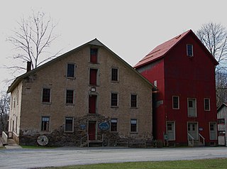
Prallsville is an unincorporated community located along New Jersey Route 29 by the border of Stockton and Delaware Township in Hunterdon County, New Jersey. The Delaware River and Wickecheoke Creek border the community. The Prallsville District was listed on the National Register of Historic Places in 1979.