
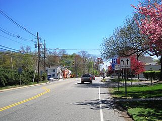
Lawrenceville is an unincorporated community and census-designated place (CDP) within Lawrence Township in Mercer County, in the U.S. state of New Jersey. The community is situated roughly halfway between Princeton and Trenton. Lawrenceville is part of the Trenton–Princeton metropolitan area within the New York combined statistical area; however, the CDP actually is located approximately 15 miles closer to Philadelphia than to New York City, and as with the remainder of Mercer County, lies within the Federal Communications Commission's Philadelphia Designated Market Area. As of the 2020 census, the CDP's population was 3,751, a decrease of 136 (−3.5%) from the 3,887 recorded at the 2010 census, which in turn had reflected a decrease of 194 (−4.8%) from the 4,081 counted in the 2000 census.

Mercer County is a county located in the U.S. state of New Jersey. Its county seat is Trenton, also the state capital, prompting its nickname The Capital County. Mercer County alone constitutes the Trenton–Princeton metropolitan statistical area and is considered part of the New York combined statistical area by the U.S. Census Bureau, but also directly borders the Philadelphia metropolitan area and is included within the Federal Communications Commission's Philadelphia Designated Media Market Area. The county is part of the Central Jersey region of the state.

East Windsor is a township in Mercer County, in the U.S. state of New Jersey. Located at the cross-roads between the Delaware Valley region to the southwest and the Raritan Valley region to the northeast, the township is an outer-ring suburb of New York City in the New York Metropolitan area, as defined by the United States Census Bureau, but directly borders the Philadelphia metropolitan area and is part of the Federal Communications Commission's Philadelphia Designated Market Area. Since East Windsor is situated at the confluence of several major highways that serve both the major cities of New York City and Philadelphia, and even the local commercial hubs of nearby Freehold, Princeton, and the state capital of Trenton, the community has been a longtime residential, commercial, and industrial hub in the heart of Central New Jersey.

Ewing Township is a township in Mercer County, in the U.S. state of New Jersey. The township falls within the New York metropolitan area as defined by the U.S. Census Bureau. It borders the Philadelphia metropolitan area and is part of the Federal Communications Commission's Philadelphia Designated Market Area. As of the 2020 United States census, the township's population was 37,264, its highest decennial count ever and an increase of 1,474 (+4.1%) from the 35,790 recorded at the 2010 census, which in turn reflected an increase of 83 (+0.2%) from the 35,707 counted in the 2000 census.

Lawrence Township is a township in Mercer County, in the U.S. state of New Jersey. Located at the cross-roads between the Delaware Valley region to the southwest and the Raritan Valley region to the northeast, the township is an outer-ring suburb of New York City in the New York Metropolitan area, as defined by the United States Census Bureau, while also directly bordering the Philadelphia metropolitan area and is part of the Federal Communications Commission's Philadelphia Designated Market Area.

Princeton Junction is an unincorporated community and census-designated place (CDP) located within West Windsor township, Mercer County, in the U.S. state of New Jersey. As of the 2020 census, the CDP's population was 2,475.

Twin Rivers is an unincorporated community and census-designated place (CDP) situated within East Windsor Township, in Mercer County, in the U.S. state of New Jersey. As of the 2020 United States census, Twin Rivers' population was 7,787 its highest decennial count ever and an increase of 344 (+4.6%) from the 7,443 recorded at the 2010 census, which in turn reflected an increase of 21 (+0.3%) from the 7,422 counted in the 2000 census. Twin Rivers was the first planned unit development in New Jersey.

Robbinsville Township is a township in Mercer County, in the U.S. state of New Jersey. It is located on the border of the New York metropolitan area and the Philadelphia metropolitan area. As of the 2020 United States census, the township's population was 15,476, its highest decennial count ever. Inspired by its central geographical location within New Jersey, Robbinsville's motto is Be at the Center of it All.

West Windsor is a township in Mercer County, in the U.S. state of New Jersey. Located at the cross-roads between the Delaware Valley region to the southwest and the Raritan Valley region to the northeast, the township is considered to be an outer-ring suburb of New York City in the New York metropolitan area, as defined by the United States Census Bureau. As of the 2020 United States census, the township's population was 29,518, its highest decennial count ever and an increase of 2,353 (+8.7%) from the 27,165 recorded at the 2010 census, which in turn reflected an increase of 5,258 (+24.0%) from the 21,907 counted in the 2000 census.

Plainsboro Township is a township situated in southern Middlesex County, in the U.S. state of New Jersey. Centrally located in the Raritan Valley region, the township is an outer-ring suburb of New York City in the New York metropolitan area, even though it is slightly geographically closer to Center City, Philadelphia than to Midtown Manhattan. As of the 2020 United States census, the township's population was 24,084, its highest decennial count ever and an increase of 1,085 (+4.7%) from the 22,999 recorded at the 2010 census, which in turn reflected an increase of 2,784 (+13.8%) from the 20,215 counted in the 2000 census.

West Freehold is an unincorporated community and census-designated place (CDP) within Freehold Township, in Monmouth County, New Jersey, United States. As of the 2010 United States Census, the CDP's population was 13,613. Due to the community's close proximity to the Battle of Monmouth, West Freehold is home to several important historical structures, which have been preserved in the 'West Freehold Village Historic District'. The historically preserved Monmouth Battlefield, along with the historic villages of Clarksburg, Englishtown, Smithburg and Tennent are a short distance away.
Grovers Mill is an unincorporated community located within West Windsor in Mercer County, in the U.S. state of New Jersey. It is centered around the intersection of Clarksville Road and Cranbury Road, adjacent to the community's mill-pond.
Deans is an unincorporated community and census-designated place (CDP) located within South Brunswick Township in Middlesex County, in the U.S. state of New Jersey.

County Route 571 is a county highway in the U.S. state of New Jersey. The highway extends 43.96 miles (70.75 km) from Route 37 in Toms River Township to Route 27 in Princeton. Though it is designated a north–south county route by the New Jersey Department of Transportation (NJDOT), it is signed both as north–south and east–west inconsistently.
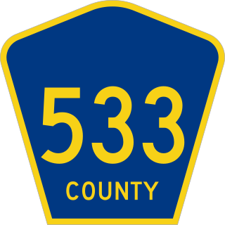
County Route 533 is a county highway in the U.S. state of New Jersey. The highway extends 32.78 miles (52.75 km) from the White Horse Circle, in Hamilton Township to Middlesex CR 607 on the border of Bound Brook and Middlesex Borough. CR 533 shares a long concurrency with U.S. Route 206 through Princeton and Montgomery Township, while portions of the roadway in Somerset County are part of the Millstone River Valley Scenic Byway.

Mercerville is an unincorporated community and census-designated place (CDP) located within Hamilton Township, in Mercer County, in the U.S. state of New Jersey. As of the 2020 census, the CDP's population was 13,447. Until after the 2000 census, the area was part of the Mercerville-Hamilton Square CDP. For the 2010 Census it was split into two CDPs, Mercerville and Hamilton Square.

Penns Neck is an unincorporated community located within West Windsor Township in Mercer County, in the U.S. state of New Jersey. The community developed at the intersection of the Trenton-New Brunswick Turnpike and Washington Road. The Penns Neck Circle and the historic Penns Neck Baptist Church (1812) are both located in Penns Neck. The Princeton Branch rail line, known as the Dinky, has run through the area since 1865, and stopped at Penns Neck station until January 1971.

Port Mercer is an unincorporated community located where the municipal boundaries of Lawrence Township, Princeton and West Windsor Township intersect in Mercer County, in the U.S. state of New Jersey. It is the location of the historic Port Mercer Canal House along the Delaware and Raritan Canal.

Berrien City, also known simply as Berrien, is an unincorporated community located within West Windsor in Mercer County, in the U.S. state of New Jersey. The neighborhood is located within the Princeton Junction census designated place centered about the intersection of Alexander Road and Scott Avenue, located within walking distance of the Princeton Junction train station and Princeton-Hightstown Road.


