
Trenton is the capital city of the U.S. state of New Jersey and the seat of Mercer County. It was the capital of the United States from November 1 to December 24, 1784. Trenton and Princeton are the two principal cities of the Trenton–Princeton metropolitan statistical area, which encompasses those cities and all of Mercer County for statistical purposes and constitutes part of the New York combined statistical area by the U.S. Census Bureau. However, Trenton directly borders the Philadelphia metropolitan area to its west, and the city was part of the Philadelphia combined statistical area from 1990 until 2000.

Mercer County is a county located in the U.S. state of New Jersey. Its county seat is Trenton, also the state capital, prompting its nickname The Capital County. Mercer County alone constitutes the Trenton–Princeton metropolitan statistical area and is considered part of the New York metropolitan area by the U.S. Census Bureau, but also directly borders the Philadelphia metropolitan area and is included within the Federal Communications Commission's Philadelphia Designated Media Market Area.

Ewing Township is a township in Mercer County, in the U.S. state of New Jersey. The township falls within the New York metropolitan area as defined by the U.S. Census Bureau. It borders the Philadelphia metropolitan area and is part of the Federal Communications Commission's Philadelphia Designated Market Area. As of the 2020 United States census, the township's population was 37,264, its highest decennial count ever and an increase of 1,474 (+4.1%) from the 35,790 recorded at the 2010 census, which in turn had reflected an increase of 83 (+0.2%) from the 35,707 counted at the 2000 census.

West Windsor is a township in Mercer County, in the U.S. state of New Jersey. Located within the Raritan Valley region, the township is an outer-ring suburb of New York City in the New York metropolitan area, as defined by the United States Census Bureau. As of the 2020 United States census, the township's population was 29,518, its highest decennial count ever and an increase of 2,353 (+8.7%) from the 27,165 recorded at the 2010 census, which in turn had reflected an increase of 5,258 (+24.0%) from the 21,907 counted at the 2000 census.
Route 175 is a short, 2.95-mile (4.75 km) long state highway in Mercer County, New Jersey, United States. The route runs along a former alignment of Route 29 before the construction of the John Fitch Parkway in the 1960s. The route begins at Route 29 in the capital city of Trenton, running along Sanhican Road, River Road, and West Upper Ferry Road into Ewing Township. The route serves primarily as a frontage road for Route 29. The northernmost portion of Route 175 is parallel to the Delaware and Raritan Canal until coming to an end at a merge with Route 29 in Ewing Township.
County Route 583 is a county highway in the U.S. state of New Jersey. Its northern end is at an intersection with Route 27 in Princeton; its southern end is in a concurrency with U.S. Route 1 Business and U.S. Route 206 at an intersection with County Route 653 in Trenton.

County Route 579 is a county highway in the U.S. state of New Jersey. The highway extends 37.24 miles (59.93 km) from John Fitch Parkway in Trenton to Route 173 in Greenwich Township.

County Route 571 is a county highway in the U.S. state of New Jersey. The highway extends 43.96 miles (70.75 km) from Route 37 in Toms River Township to Route 27 in Princeton. Though it is designated a north–south county route by the New Jersey Department of Transportation (NJDOT), it is signed both as north–south and east–west inconsistently.

County Route 539 is a county highway in the U.S. state of New Jersey. The highway extends 54.32 miles (87.42 km) from Main Street in Tuckerton to CR 535 in Cranbury Township. Much of the two-lane route passes through isolated areas of the Pine Barrens and the eastern end of the Fort Dix entity of Joint Base McGuire–Dix–Lakehurst. In these stretches, the route has a speed limit of 55 miles per hour (89 km/h), one of the few two-lane roads in the state to carry a 55 mph limit. CR 539 passes through three boroughs: Tuckerton, Allentown, and Hightstown. Other than those boroughs, the route travels mainly through rural townships.

County Route 535 is a county highway in the U.S. state of New Jersey. The highway extends 32.31 miles (52.00 km) from Logan Avenue, at the boundary between Trenton and Hamilton Township in Mercer County to an interchange with U.S. Route 9 (US 9) and Route 35 in South Amboy, Middlesex County.
The Trenton Bath House is an influential design by the architect Louis Kahn, with the help of his associate, architect Anne Tyng. This changing room facility is located adjacent to a swimming pool at 999 Lower Ferry Road, Ewing Township, Mercer County, New Jersey, United States. It was listed in the National Register of Historic Places in 1984.

County Route 528 is a county highway in the U.S. state of New Jersey. The highway is designated 39.89 miles (64.20 km) from Farnsworth Avenue in Bordentown to Ocean Avenue in Mantoloking. The eastern end of the highway sustained extensive damage in 2012 when an inlet opened between Barnegat Bay and the Atlantic Ocean during Hurricane Sandy, scouring away the road east of the Mantoloking Bridge. The bridge and Route 35 intersection fully reopened in February 2013.

Ewingville is a section of Ewing Township in Mercer County, New Jersey, United States originally settled as a village on Shabakunk Creek. Located at the intersection of Ewingville Road/Upper Ferry Road and Pennington Road, it is one of the oldest settlements in Ewing Township and dates back to the 18th century. The community was known as Cross Keys before adopting its current name in 1836, two years after the incorporation of Ewing Township in 1834.

Trenton–Mercer Airport is a county-owned, joint civil–military, public airport located four miles northwest of Trenton in the West Trenton section of Ewing Township, Mercer County, New Jersey. Formerly known as Mercer County Airport, the airport serves one scheduled airline plus general and corporate aviation. The U.S. Department of Transportation reports that approximately 201,000 passengers departed and 200,000 arrived at the airport in the 12 months ending October 2021, for a total of 401,000 passengers.
Wilburtha is a section of Ewing Township in Mercer County, New Jersey, United States. Located where Wilburtha Road crosses the Delaware and Raritan Canal, it is one of the oldest settlements in Ewing Township and developed due to the construction of the canal in the early 19th century. The community was known as Greensburg before adopting its current name in 1883. The Yardley–Wilburtha Bridge once connected Wilburtha to Yardley, Pennsylvania on the other side of the Delaware River. The Belvidere Delaware Railroad once passed through the village. Today, Wilburtha is primarily a residential neighborhood consisting of detached, single-family homes, the majority of which were built in the 1950s through the early 1980s. There are still many Georgian and Federal-style homes found in the area.

Bear Tavern is an unincorporated community located within Hopewell Township in Mercer County, New Jersey, United States.

Berrien City, also known simply as Berrien, is an unincorporated community located within West Windsor Township in Mercer County, New Jersey, United States. The area is located within the Princeton Junction census designated place centered about the intersection of Alexander Road and Scott Avenue, located within walking distance of the Princeton Junction train station and Princeton-Hightstown Road. It was developed as an upper-middle class development after World War I and features homes constructed about 100 years ago. Most of the homes still exist with some small businesses located along Alexander Road with the West Windsor Arts Center operating its facilities out of the former Princeton Junction Fire Company fire station.

Ewing is a section of Ewing Township in Mercer County, New Jersey, United States. Located at the intersection of Upper Ferry Road and Scotch Road, it is one of the oldest settlements in Ewing Township and dates back to the 18th century. The community was known as Carleton before adopting its current name.
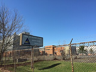
Naval Air Warfare Center Trenton is the former site of United States Navy facility in the West Trenton section of Ewing Township, New Jersey, just outside the city of Trenton. Opened during the final year of the Korean War in 1953, the center encompassed 528 acres (214 ha) on Parkway Avenue in Ewing, directly adjacent to the Trenton–Mercer Airport. It was used as a jet engine test facility for the US Navy until its closure per recommendations of the 1993 Base Closure and Realignment Commission, due to Navy decision making under President George H. W. Bush. Nearly 700 civilian positions were lost, most of which were relocated to other facilities in Maryland and Tennessee. The base's Marine operations were transferred to Fort Dix, which has since become Joint Base McGuire-Dix-Lakehurst. HomeFront, a charity to end homelessness, acquired the base at no cost in October 2013 in a process involving the United States Department of Defense, the United States Department of Housing and Urban Development, Mercer County and Ewing Township.
Marie H. Katzenbach School for the Deaf (MKSD), also known as the New Jersey School for the Deaf and Blind, initially the New Jersey State Institution for the Deaf , is a K-12 statewide school in West Trenton, Ewing Township, New Jersey. Its age range is pre-Kindergarten to age 21. The New Jersey Department of Education oversees the school. It is named after Marie Hilson Katzenbach.


