
Rosedale is an unincorporated community in central Pike Township, Madison County, Ohio, United States, and roughly thirty miles west of the city of Columbus. The ZIP code is 43029 and mail is currently delivered by the Irwin post office.

Elton is an unincorporated community located within Manalapan Township, in Monmouth County, New Jersey, United States.
Montrose is an unincorporated community located near the intersection of Dutch Lane Road and Boundary Road along the border of Colts Neck and Marlboro townships in Monmouth County, New Jersey, United States. The historic one-room Montrose Schoolhouse, built before 1820, is located in the Colts Neck portion of the community.

Prospertown is an unincorporated community located within the New Jersey townships of Jackson and Plumsted in Ocean County and Upper Freehold in Monmouth County. The community is home to Prospertown Lake and is adjacent to Six Flags Great Adventure, both located on County Route 537. The center of the community is located at the intersection of CR 537, Hawkin Road, and Emleys Hill Road. Most of the area consists of pine forests but there are some homes along the roads in the area.

Centerville is an unincorporated community located within Hopewell Township in Mercer County, New Jersey, United States. The community is located at the intersection of Pennington-Rocky Hill Road and Titus Mill Road. Bristol-Myers Squibb's Hopewell Campus is located in Centerville.

Bakersville, also known as Bakers Basin, is an unincorporated community located within Lawrence Township in Mercer County, New Jersey, United States. The center of the community is located at the intersection of U.S. Route 1, Franklin Corner Road, and Bakers Basin Road.

Harneys Corner is an unincorporated community located within Lawrence Township in Mercer County, New Jersey, United States. It is located at the intersection of Lawrence Road and Princeton Pike / Avenue. Located in the southern portion of the township close to the Trenton and Ewing borders, the area consists of small houses on nearby side streets and businesses along the aforementioned arterial roads. The intersection itself is located about 0.3 miles (0.48 km) north of the Brunswick Circle.

Ackors Corner is an unincorporated community located within Hopewell Township in Mercer County, New Jersey, United States. The settlement is located at the intersection of Bear Tavern Road / Trenton-Harbourton Road, Pennington-Harbourton Road and Pleasant Valley Road. It is named for the Ackors family which owned land near the current intersection. Small residences and farmland make up the area surrounding Ackors Corner but the area rises in elevation from east to west as one approaches Baldpate Mountain, part of the Sourland Mountain range.

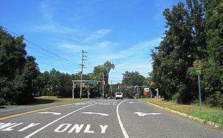
Pages Corners or Pages Corner is an unincorporated community located within Robbinsville Township in Mercer County, New Jersey, United States. The intersection defining the corners is at Sharon Road and Gordon Road. The intersection is at a skewed angle which led to numerous accidents. The township installed a traffic signal at the intersection and activated it on September 25, 2015.

Amwell is an unincorporated community located at the tripoint of East Amwell Township in Hunterdon County and Hillsborough and Montgomery townships in Somerset County, in New Jersey, United States. The community is located along Spring Hill Road near its intersection with Zion Road and is located along the top of the Sourland Mountain.

Redshaw Corner is an unincorporated community located within Old Bridge Township in Middlesex County, New Jersey, United States. The settlement is located at the intersection of Old Bridge–Englishtown Road and Texas Road. A cluster of businesses are found around this intersection while some housing developments are located west of CR 527. New developments are in the process of being constructed in the sandy areas of land east of CR 527.

Everett is an unincorporated community located along the border of Holmdel and Middletown townships in Monmouth County, New Jersey, United States. The community is located on Everett Road, along which the township line runs, at its intersection with Stillwell Road and Sunnyside Road. Most of the area in Everett is composed of homes with some farmlands nearby. Holmdel's Bell Labs Complex is located to the west of Everett.

Herberts Corner is an unincorporated community located within Marlboro Township in Monmouth County, New Jersey, United States. The center of the community is located at the intersection of Wyncrest Road and Newman Springs Road.
Hillsdale is an unincorporated community located within Colts Neck and Marlboro townships in Monmouth County, New Jersey, United States. The community is located at the intersection of County Route 520 which runs east and west, Conover Road which heads north, and Boundary Road which heads south. The southeastern quadrant of this intersection is a part of Colts Neck while the other three are in Marlboro. The community is located atop a small hill and is largely rural. The Colts Neck quadrant is made up of a housing development while the Marlboro side is mostly forests, parkland, and the remains of the Marlboro Psychiatric Hospital.
Holland is an unincorporated community located on the border of Holmdel and Middletown townships in Monmouth County, New Jersey, United States. The community is centered on the intersection of County Route 52 and Holland Road. The area making up Holland is hilly and consists of large single-family residences. An AT&T Labs campus is located off Laurel Avenue while Tatum County Park is also located in the area, both of which are on the Middletown side of the border.

Kirbys Mills is an unincorporated community located within Upper Freehold Township in Monmouth County, New Jersey, United States. Centered near the intersection of Burlington Path Road and Holmes Mill Road, the area consists of housing developments and small farms.

Matthews is an unincorporated community located within Howell Township in Monmouth County, New Jersey, United States. The settlement is located on the western border of the township near Jackson Township, Ocean County and Interstate 195. It is located about the intersection of Hulses Corner Road and Fort Plains Road. The Howell side of the North Branch Metedeconk River is mainly rural with only a few houses located along the main surface roads while the Jackson side of the river is more suburbanized.

Scotts Corner or Scotts Corners is an unincorporated community located within Plainsboro Township in Middlesex County, New Jersey, United States. The corner itself is located at the intersection of Scotts Corner Road and Dey Road in the eastern portion of the township. The area contains residential neighborhoods on all four quadrants of the intersection; an apartment complex comprises the southwestern corner of it while single-family housing developments are located in the other three corners.
Stone Church is an unincorporated community located in Middletown Township in Monmouth County, New Jersey, United States, within the census-designated place of Navesink. The settlement is located at the intersection of Valley Road and Locust Avenue, Navesink Avenue, and Monmouth Avenue. In the center of the community, the historic All Saint's Memorial Episcopal Church built in 1864 sits at the main intersection. The remainder of the area consists of single-family houses and forests on the slopes of nearby Mount Mitchill.

Ellisdale is an unincorporated community located along the border of North Hanover Township in Burlington County and Upper Freehold Township in Monmouth County, in New Jersey, United States. The community is centered about the intersection of Province Line Road and Hill Road / Ellisdale-Crosswicks Road. The Crosswicks Creek runs to the north of the settlement and the nearby Ellisdale Fossil Site takes its name from Ellisdale.


