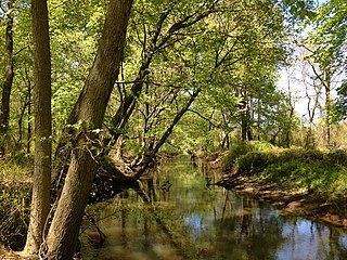
Assunpink Creek is a 22.9-mile-long (36.9 km) tributary of the Delaware River in western New Jersey in the United States. The name Assunpink is from the Lenape Ahsën'pink, meaning "stony, watery place".

Mill Hill is a historic neighborhood located within the city of Trenton in Mercer County, New Jersey, United States. It is considered to be part of Downtown Trenton and was added to the National Register of Historic Places in 1977. The name Mill Hill refers to central New Jersey's first industrial site, a mill, erected in 1679, at the southeast corner of the present Broad Street crossing of the Assunpink Creek. Mill Hill and its wooden mill were among the holdings of the first settler in the vicinity of Trenton, Mahlon Stacy, a Quaker who arrived in North America in 1678. The mill was destroyed in a flood.

Glenmoore is an unincorporated community located within Hopewell Township in Mercer County, New Jersey, United States. Single-family homes make up most of the land in the area though two golf courses, the Hopewell Valley Golf Club and the Stonybrook Golf Club, are located in Glenmoore. The settlement is centered about the intersection of Pennington-Hopewell Road and Moores Mill-Mount Rose Road.

Hillside Terrace is an unincorporated community located within Robbinsville Township in Mercer County, New Jersey, United States. The community consists of single-family houses on both sides of Robbinsville-Allentown Road between U.S. Route 130 and the New Jersey Turnpike. The original section of the neighborhood near the intersection of CR 526 and Spring Garden Road was constructed between the late 1950s and the early 1960s. A more modern subdivision was constructed on the southwestern side of CR 526 by 1995 consisting of larger homes.

New Canton is an unincorporated community located along the border of Robbinsville Township in Mercer County and Upper Freehold Township in Monmouth County, New Jersey, United States. The area was once known as Cabbagetown and has been settled since the 18th century. The settlement is located at the intersection of Old York Road and New Canton-Stone Tavern Road just north of Interstate 195's interchange 8. The Upper Freehold side of the area contains farmland and new housing developments while the Robbinsville side features new commercial warehouse buildings including an Amazon.com Fulfillment Center opened in July 2014.

New Sharon is an unincorporated community located along the border of Robbinsville Township in Mercer County and Upper Freehold Township in Monmouth County, New Jersey, United States. Old York Road passes through the center of the community.

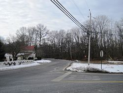
Pages Corners or Pages Corner is an unincorporated community located within Robbinsville Township in Mercer County, New Jersey, United States. The intersection defining the corners is at Sharon Road and Gordon Road. The intersection is at a skewed angle which led to numerous accidents. The township installed a traffic signal at the intersection and activated it on September 25, 2015.
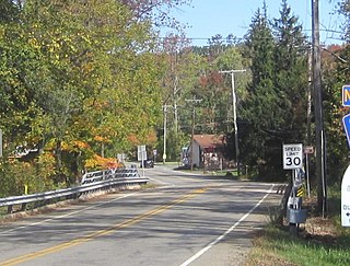
Croton is an unincorporated community located along the border of Delaware and Raritan townships in Hunterdon County, New Jersey, United States. County Route 579 is the main north–south road through the area which consists of mostly forest within the Hunterdon Plateau and some houses and businesses along Route 579 and nearby New Jersey Route 12. The headwaters of the Wickecheoke Creek are located northeast of Croton before it heads downstream through the community on its way to the Delaware River.

Idell is an unincorporated community located within Kingwood Township in Hunterdon County, New Jersey, United States. The community is located at the crossing of Byram-Kingwood Road over the Lockatong Creek. The area is very rural and consists of small farms, houses, and forest land.

Wyckoffs Mills is an unincorporated community located along the border of Cranbury and Monroe townships in Middlesex County, New Jersey, United States. Located at the intersection of Wyckoff Mills Road and Wyckoffs Mills Road, the area only contains lots containing residential structures; the remainder of the land is made up of farmland and wetlands. The Millstone River flows to the south of the settlement and a 500-kilovolt transmission line crosses the farmland to the north and south.

Bergen Mills is an unincorporated community located within Millstone Township in Monmouth County, New Jersey, United States. Centered on Bergen Mills Road, Millstone Road, and Route 33, the area is made up of mostly farmland with some residential homes scattered about, small business along Route 33, and a rock quarry on Old Bergen Mills Road.

Cooleys Corner is an unincorporated community located within Upper Freehold Township in Monmouth County, New Jersey, United States. The site of the settlement is within the Assunpink Wildlife Management Area, a New Jersey Department of Environmental Protection Division of Fish and Wildlife-operated preserved area in Monmouth and Mercer counties along the Assunpink Creek. Before the creation of the Assunpink Lake in the 1970s, the area consisted of farmland located at the intersection of Clarksburg Road and Imlaystown-Hightstown Road. Some farmland is still present in the area but is now mostly used by hunters. The main boat ramp to Assunpink Lake is located along the former Imlaystown-Hightstown Road.

Kirbys Mills is an unincorporated community located within Upper Freehold Township in Monmouth County, New Jersey, United States. Centered near the intersection of Burlington Path Road and Holmes Mill Road, the area consists of housing developments and small farms.

Philips Mills or Philip Mills is an unincorporated community located along the border of Holmdel and Middletown townships in Monmouth County, New Jersey, United States. It is located about the intersection of Palmer Avenue and Middle Road and Main Street. Around the area, some small businesses are located along the main arterial roads; single-family houses dot the area mostly towards the east side of the community. Throughout most of the west side, wooded areas lining the Waackaack Creek are found.

Pullentown is an unincorporated community located within Upper Freehold Township in Monmouth County, New Jersey, United States. The settlement is located along County Route 526 east of Allentown and just west of its intersection with Sharon Station Road. The area contains mostly farmland with some homes and small businesses located along the road.

Robinsville is an unincorporated community located within Upper Freehold Township in Monmouth County, New Jersey, United States. Located in the northeastern corner of the township near Millstone Township and Roosevelt, the area is located wholly in the Assunpink Wildlife Management Area, the area consists of forest and some farmland that was in existence prior to the creation of the WMA in the 1970s.

Headquarters is an unincorporated community located within Delaware Township in Hunterdon County, New Jersey, United States. The settlement is centered aon the crossing of Zentek Road over the Caponockons Creek, near the intersection of Zentek Road and Ringoes-Rosemont Road. The area is part of the Headquarters Historic District, a listing on the National Register of Historic Places. Headquarters was the site of a mill established in 1735, one of the first in Hunterdon County. The industry thrived until the early 20th century when the mill shut down. The district was first established as a historic area by Delaware Township in the 1980s to push back against a widening of CR 604. It is now on the national list of historic districts with a renewal of its boundaries occurring in 2016.

Sharon is an unincorporated community located within Upper Freehold Township in Monmouth County, New Jersey, United States. Located at the intersection of Herbert Road and Sharon Station Road, the settlement is the site of a former stop on the Pemberton and Hightstown Railroad. Except for a few single-family homes in the area, most of the area is farmland. The railroad has since been abandoned and is being converted to the Union Transportation Trail, a rail trail. Sharon is the current northern terminus of the trail.

Spring Mill is an unincorporated community located within Upper Freehold Township in Monmouth County, New Jersey, United States. The settlement is located along County Route 524 between Hamilton Township and Allentown on a commercialized segment of the road originally built as New Jersey Route 37. A vestige of the state construction remains along the road through a wide right-of-way and a bridge crossing Doctor's Creek stating that it was constructed by the state in 1940 for State Highway Route 37.

Dunns Mill or Dunns Mills is an unincorporated community located within Bordentown Township in Burlington County, New Jersey, United States. The site is named for a gristmill established in 1708 that is located near the settlement along Blacks Creek. Martin Luther Dunn purchased the mill in 1875 but burned down in 1901. The site is presently located near the crossing of the New Jersey Turnpike over County Route 545. A mix of housing developments and preserved open space are located around Dunns Mill today.