
Trenton is the capital city of the U.S. state of New Jersey and the county seat of Mercer County. It briefly served as the capital of the United States in 1784. The city's metropolitan area, consisting of Mercer County, is grouped with the New York Combined Statistical Area by the United States Census Bureau, but it directly borders the Philadelphia metropolitan area and was from 1990 until 2000 part of the Philadelphia Combined Statistical Area. As of the 2010 United States Census, Trenton had a population of 84,913, making it the state's 10th-largest municipality after having been the state's ninth-largest municipality in 2000. The population declined by 490 (-0.6%) from the 85,403 counted in the 2000 Census, which had in turn declined by 3,272 (-3.7%) from the 88,675 counted in the 1990 Census. The Census Bureau's Population Estimates Program estimated that the city's population was 83,974 in 2018.

Newark is the most populous city in the U.S. state of New Jersey and the seat of Essex County. As one of the nation's major air, shipping, and rail hubs, the city had a population of 282,090 in 2018, making it the nation's 73rd-most populous municipality, after being ranked 63rd in the nation in 2000.

Mercer County is a county located in the U.S. state of New Jersey. Its county seat is Trenton, the state capital. The county constitutes the Trenton-Ewing, NJ Metropolitan Statistical Area and is considered part of the New York Metropolitan Area by the United States Census Bureau, but also directly borders the Philadelphia metropolitan area and is included within the Federal Communications Commission's Philadelphia Designated Market Area. As of the 2018 Census estimate, the county's population was 369,811, making it the state's 12th-most populous county, an increase of 2.2% from the 2010 United States Census, when its population was enumerated at 366,513, in turn an increase of 15,752 (4.5%) from the 350,761 enumerated in the 2000 Census, retaining its position as the 12th-most populous county in the state.

Alpine is a borough in Bergen County, New Jersey, United States. It is located 15 miles (24 km) north of midtown Manhattan. It is the easternmost community in the state of New Jersey.

Franklin Lakes is a borough in Bergen County, New Jersey, United States. As of the 2010 census, the borough's population was 10,590, reflecting an increase of 168 (+1.6%) from the 10,422 counted in the 2000 Census, which had in turn increased by 549 (+5.6%) from the 9,873 counted in the 1990 Census. Becton Dickinson, a Fortune 500 company, is headquartered in Franklin Lakes.

Ewing Township is a township in Mercer County, New Jersey, United States. The township is within the New York metropolitan area as defined by the United States Census Bureau. It also directly borders the Philadelphia metropolitan area and is part of the Federal Communications Commission's Philadelphia Designated Market Area. As of the 2010 United States Census, the township's population was 35,790, reflecting an increase of 83 (+0.2%) from the 35,707 counted in the 2000 Census, which had increased by 1,522 (+4.5%) from the 34,185 counted in the 1990 Census.

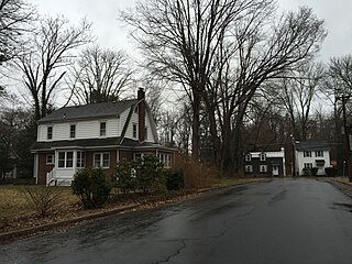
West Trenton is a section of Ewing Township in Mercer County, New Jersey, United States. It is a suburban area located adjacent to the northwestern portion of the city of Trenton, from which it derives its name. Located at the intersection of Bear Tavern Road/Grand Avenue and West Upper Ferry Road, it is one of the oldest settlements in Ewing Township.
Cherry Hill is a township in Camden County, New Jersey, United States. As of the 2010 United States Census, the township had a population of 71,045, reflecting an increase of 1,080 (+1.5%) from the 69,965 counted in the 2000 Census, which had in turn increased by 617 (+0.9%) from the 69,348 counted in the 1990 Census. As of 2010, the township was the state's 15th most populous municipality and the second-largest in Camden County, after having been the state's 13th most populous municipality in the 2000 Census. An edge city of Philadelphia, Cherry Hill is situated on the Delaware Valley coastal plain, approximately 8 miles (13 km) southeast of Center City, Philadelphia.

Ewingville is a section of Ewing Township in Mercer County, New Jersey, United States originally settled as a village on Shabakunk Creek. Located at the intersection of Ewingville Road/Upper Ferry Road and Pennington Road, it is one of the oldest settlements in Ewing Township and dates back to the 18th century. The community was known as Cross Keys before adopting its current name in 1836, two years after the incorporation of Ewing Township in 1834.
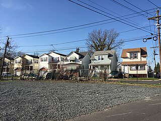
Wilburtha is a section of Ewing Township in Mercer County, New Jersey, United States. Located where Wilburtha Road crosses the Delaware and Raritan Canal, it is one of the oldest settlements in Ewing Township and developed due to the construction of the canal in the early 19th century. The community was known as Greensburg before adopting its current name in 1883. The Yardley–Wilburtha Bridge once connected Wilburtha to Yardley, Pennsylvania on the other side of the Delaware River. The Belvidere Delaware Railroad once passed through the village. Today, Wilburtha is primarily a residential neighborhood consisting of detached, single-family homes, the majority of which were built in the 1950s through the early 1980s.

The Shabakunk Creek is a tributary of the Assunpink Creek in Mercer County, New Jersey, United States. Via the Assunpink, its water ultimately flows into the Delaware River. The name Shabakunk is from the Lenape word meaning "shore land".

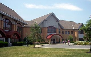
Lake Sylva is an 11-acre man-made lake along the Shabakunk Creek on the campus of The College of New Jersey in Ewing, Mercer County, New Jersey, United States. The lake was created when an earthen dam was constructed across the Shabakunk in the 1920s by a local landowner, prior to the construction of the current college campus. It once contained several islands, but these were removed during a dredging project in 1988-1989. The lake is adjacent to Lake Ceva, and together the two lakes are the basis of the name of the Hillwood Lakes section of Ewing.

Glendale is a neighborhood located within Ewing Township in Mercer County, New Jersey, United States.

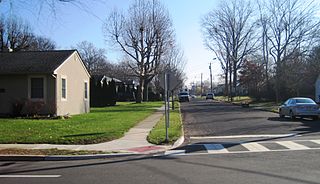
Prospect Heights is a neighborhood located within Ewing Township in Mercer County, New Jersey, United States. It is a residential neighborhood primarily consisting of detached, single-family homes built in the 1920s through the 1970s.
Slackwood is an unincorporated community located within Lawrence Township in Mercer County, New Jersey, United States. The area is named for the owners of the land that was subdivided into the neighborhood today, Joseph Slack and William Wood. The neighborhood was first developed in 1890 as the first suburban development in the reconfigured Lawrence Township. Its location between Princeton Pike and Brunswick Pike allowed for an easy walk to nearby Trenton factories. Today, most of the homes in Slackwood are still small bungalows with some businesses along Princeton and Brunswick Pikes. The neighborhood is bounded by the two highways on the northwest and southeast, Slackwood Park and forest on the southwest, and Shabakunk Creek and Park on the northeast.

Braeburn Heights is a neighborhood located within Ewing Township in Mercer County, New Jersey, United States. It is a residential neighborhood primarily consisting of detached, single family homes built from the 1940s through the 1970s.
Prospect Park is a neighborhood located within Ewing Township in Mercer County, New Jersey, United States.

Hillwood Lakes is a neighborhood located within Ewing Township in Mercer County, New Jersey, United States. It is centered on and immediately north of The College of New Jersey. The neighborhood takes its name from two lakes in the area, Lake Sylva and Lake Ceva.

Lake Ceva is a 6-acre (2.4 ha) man-made lake near the Shabakunk Creek on the campus of The College of New Jersey in Ewing Township, Mercer County, New Jersey, United States. The lake was created when an earthen dam was constructed across a small tributary of the Shabakunk in the 1920s by a local landowner, prior to the construction of the current college campus. The lake is adjacent to Lake Sylva, and together the two lakes are the basis of the name of the Hillwood Lakes section of Ewing.


