
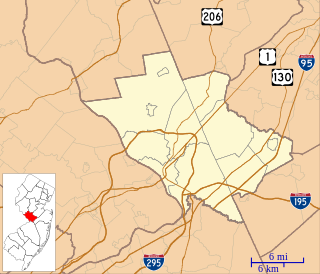
Mercer County is a county located in the U.S. state of New Jersey. Its county seat is Trenton, the state capital. The county constitutes the Trenton-Ewing, NJ Metropolitan Statistical Area and is considered part of the New York Metropolitan Area by the United States Census Bureau, but also directly borders the Philadelphia metropolitan area and is included within the Federal Communications Commission's Philadelphia Designated Market Area. As of the 2018 Census estimate, the county's population was 369,811, making it the state's 12th-most populous county, an increase of 2.2% from the 2010 United States Census, when its population was enumerated at 366,513, in turn an increase of 15,752 (4.5%) from the 350,761 enumerated in the 2000 Census, retaining its position as the 12th-most populous county in the state.

Ewing Township is a township in Mercer County, New Jersey, United States. The township is within the New York metropolitan area as defined by the United States Census Bureau. It also directly borders the Philadelphia metropolitan area and is part of the Federal Communications Commission's Philadelphia Designated Market Area. As of the 2010 United States Census, the township's population was 35,790, reflecting an increase of 83 (+0.2%) from the 35,707 counted in the 2000 Census, which had increased by 1,522 (+4.5%) from the 34,185 counted in the 1990 Census.

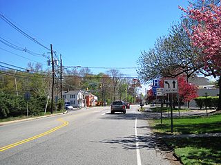
Hopewell is a borough in Mercer County, New Jersey, United States. As of the 2010 United States Census, the borough's population was 1,922, reflecting a decline of 113 (-5.6%) from the 2,035 counted in the 2000 Census, which had in turn increased by 67 (+3.4%) from the 1,968 counted in the 1990 Census.

Pennington is a borough in Mercer County, New Jersey, United States. As of the 2010 United States Census, the borough's population was 2,585, reflecting a decline of 111 (-4.1%) from the 2,696 counted in the 2000 Census, which had in turn increased by 159 (+6.3%) from the 2,537 counted in the 1990 Census.
Deans is an unincorporated community located within South Brunswick Township in Middlesex County, New Jersey, United States.

New Lisbon is an unincorporated community located within Pemberton Township in Burlington County, New Jersey, United States. It is a settlement along Four Mile Road where it intersects Mount Misery Road. The community is located along the Philadelphia and Long Branch Railway, later a part of the Pennsylvania Railroad, and featured a train station.

Hopewell station is located in Hopewell, Mercer County, New Jersey, United States. The station was built in 1876. The head house has been on the state and federal registers of historic places since 1984 and was originally listed as part of the Operating Passenger Railroad Stations Thematic Resource. New Jersey Transit has proposed reopening the station to railroad service as part of the West Trenton Line.

Bakersville, also known as Bakers Basin, is an unincorporated community located within Lawrence Township in Mercer County, New Jersey, United States. The center of the community is located at the intersection of U.S. Route 1, Franklin Corner Road, and Bakers Basin Road.

Penns Neck is an unincorporated community located within West Windsor Township in Mercer County, New Jersey, United States. The community developed at the intersection of the Trenton-New Brunswick Turnpike and Washington Road. The Penns Neck Circle and the historic Penns Neck Baptist Church (1812) are both located in Penns Neck. The Princeton Branch rail line, known as the Dinky, has run through the area since 1865, and stopped at Penns Neck station until January 1971.

Ackors Corner is an unincorporated community located within Hopewell Township in Mercer County, New Jersey, United States. The settlement is located at the intersection of Bear Tavern Road / Trenton-Harbourton Road, Pennington-Harbourton Road and Pleasant Valley Road. It is named for the Ackors family which owned land near the current intersection. Small residences and farmland make up the area surrounding Ackors Corner but the area rises in elevation from east to west as one approaches Baldpate Mountain, part of the Sourland Mountain range.

East Trenton Heights is an unincorporated community within Hamilton Township in Mercer County, New Jersey, United States. The area is made up of residential single-family homes, but development on the site of the former American Standard factory is bringing condominiums and commercial offices to the area. The Hamilton train station on the Northeast Corridor railroad line is in the area of East Trenton Heights. Sloan Avenue and Sweet Briar Avenue is the main east-west road through the area and provides access to the nearby Interstate 295.
Moore is an unincorporated community located within Hopewell Township in Mercer County, New Jersey, United States.
Lawrence Station is an unincorporated community located within Lawrence Township in Mercer County, New Jersey, United States. The settlement is named for a former railroad station on the Pennsylvania Railroad's New York Division line, now a part of the Northeast Corridor. Today, some wooded areas and buildings from the time of the station remain but more townhouse developments, cultural centers, and industrial facilities are located along the main road through the area, Lawrence Station Road.
Maple Shade is an unincorporated community located within Hamilton Township in Mercer County, New Jersey, United States.

Battle Monument, also known as Five Points, is a neighborhood located within the city of Trenton in Mercer County, New Jersey, United States. The name Battle Monument is in reference to the Trenton Battle Monument, which sits just south of the Five Points formed from the intersection of Pennington Avenue, Princeton Avenue, Brunswick Avenue, North Broad Street and North Warren Street. The Philadelphia and Reading Railroad Freight Station is in the neighborhood.

Hoffman is an unincorporated community located within Monroe Township in Middlesex County, New Jersey, United States. The settlement is located at the site of a former railroad station on the Freehold and Jamesburg Agricultural Railroad. Today, most of the area is made up of homes and housing developments along Hoffman Station Road and Gravel Hill-Spotswood Road. Forestland and the Manalapan Brook valley make up the remainder of the area.
Tracy is an unincorporated community located within Monroe Township in Middlesex County, New Jersey, United States. The settlement is located at the site of a former station on the Freehold and Jamesburg Agricultural Railroad in the southeastern edge of the township. Most of the area is forestland with some homes and light commercial businesses located along Federal Road and Tracy Station Road.

Ewansville or Ewanville is an unincorporated community located in Burlington County, New Jersey, United States. The community is centered on the crossing of U.S. Route 206 (US 206) and the North Branch Rancocas Creek just north of the former Philadelphia and Long Branch Railway. Ewansville was the site of a station on the aforementioned railroad and was the terminus for a short spur track to Vincentown.

Sharon is an unincorporated community located within Upper Freehold Township in Monmouth County, New Jersey, United States. Located at the intersection of Herbert Road and Sharon Station Road, the settlement is the site of a former stop on the Pemberton and Hightstown Railroad. Except for a few single-family homes in the area, most of the area is farmland. The railroad has since been abandoned and is being converted to the Union Transportation Trail, a rail trail. Sharon is the current northern terminus of the trail.

Browns Mills Junction is an unincorporated community located within Pemberton Township in Burlington County, New Jersey, United States. The site, located about 1.6 miles (2.6 km) southwest of downtown Browns Mills, is located at the crossing of Junction Road and the Philadelphia and Long Branch Railway, later a part of the Pennsylvania Railroad. It was the site of a train station named Browns Mills in-the-Pines where a short branch connected the main line to Browns Mills. The settlement features a few houses along Junction Road and Mount Misery Road but is otherwise very forested as a part of the New Jersey Pine Barrens.


