Interstate 95 (I-95) is a major Interstate Highway that traverses nearly the full extent of the East Coast of the United States, from Florida to Maine. In the state of New Jersey, it runs along much of the mainline of the New Jersey Turnpike, as well as the Pearl Harbor Memorial Extension, and the New Jersey Turnpike's I-95 Extension to the George Washington Bridge for a total of 77.96 mi (125.46 km). Located in the northeastern part of the state near New York City, the 11.03-mile (17.75 km) Western Spur of the New Jersey Turnpike, considered to be Route 95W by the New Jersey Department of Transportation (NJDOT), is also part of I-95.
County Route 533 is a county highway in the U.S. state of New Jersey. The highway extends 32.78 miles (52.75 km) from the White Horse Circle, in Hamilton Township to Middlesex CR 607 on the border of Bound Brook and Middlesex Borough. CR 533 shares a long concurrency with U.S. Route 206 through Princeton and Montgomery Township, while portions of the roadway in Somerset County are part of the Millstone River Valley Scenic Byway.

Raven Rock is an unincorporated community and hamlet along the Delaware River approximately three miles (4.8 km) north of Stockton along New Jersey Route 29. The hamlet was known earlier as Saxtonville. It is located within Delaware Township in Hunterdon County, New Jersey, United States. It is the site of Bull's Island Recreation Area. The rock outcrop for which it is named is the southwest corner of the Hunterdon Plateau.

Locust is an unincorporated community located within Middletown Township in Monmouth County, New Jersey, United States. It is situated along the north banks of the Navesink River and Claypit Creek. The area consists of mostly medium-to-large sized houses throughout the hilly terrain of this part of the township. The Oceanic Bridge connects Locust with Rumson to the south.

Mill Hill is a historic neighborhood located within the city of Trenton in Mercer County, New Jersey, United States. It is considered to be part of Downtown Trenton and was added to the National Register of Historic Places in 1977. The name Mill Hill refers to central New Jersey's first industrial site, a mill, erected in 1679, at the southeast corner of the present Broad Street crossing of the Assunpink Creek. Mill Hill and its wooden mill were among the holdings of the first settler in the vicinity of Trenton, Mahlon Stacy, a Quaker who arrived in North America in 1678. The mill was destroyed in a flood.

Stoutsburg is an unincorporated community located along the border of Hopewell Township in Mercer County and Montgomery Township in Somerset County, New Jersey, United States. County Route 518 passes through the community from the east and west, while Province Line Road passes through north and south. Province Line Road follows the Keith line which formerly separated the provinces of West Jersey and East Jersey, now parts of Hopewell and Montgomery townships respectively.

Jacobstown is an unincorporated community located within North Hanover Township, in Burlington County, New Jersey, United States. Jacobstown got its name from a Quaker named Jacob Andrew. The community houses the North Hanover Township municipal building, courthouse, and two elementary schools within the North Hanover Township School District.
Smithburg is an unincorporated community located where the municipal boundaries of Freehold, Manalapan and Millstone townships intersect in Monmouth County, New Jersey, United States. County Route 527 and Monmouth Road pass through the center of the quaint village of Smithburg.
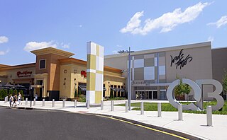
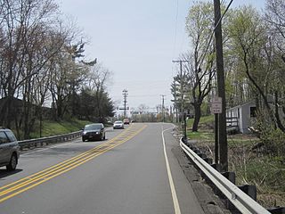
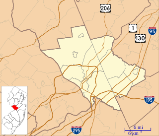
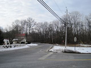
Clarksville is an unincorporated community partially in Lawrence Township, and partially in West Windsor Township, in Mercer County, New Jersey, United States. It was historically centered at the intersection of the Trenton-New Brunswick Turnpike, Quakerbridge Road and Province Line Road, and had a blacksmith shop, saloon, store, hotel and school. Today, Clarksville is dominated by several large shopping centers, including the Quaker Bridge Mall.
North Crosswicks is an unincorporated community located within Hamilton Township in Mercer County, New Jersey, United States. Residential homes, a cemetery, and farmland make up the area around North Crosswicks. Located across the Crosswicks Creek from the Chesterfield Township settlement of Crosswicks, a covered bridge formerly connected the two localities.

Penns Neck is an unincorporated community located within West Windsor Township in Mercer County, New Jersey, United States. The community developed at the intersection of the Trenton-New Brunswick Turnpike and Washington Road. The Penns Neck Circle and the historic Penns Neck Baptist Church (1812) are both located in Penns Neck. The Princeton Branch rail line, known as the Dinky, has run through the area since 1865, and stopped at Penns Neck station until January 1971.
Carsons Mills is an unincorporated community located within Robbinsville Township in Mercer County, New Jersey, United States. The community is located at the junctions of the Assunpink Creek and the New Sharon Branch creek and Sharon Road and Windsor Road southeast of the New Jersey Turnpike. Developed areas nearby include small residences and farmland while the undeveloped areas are forest and floodplains as a part of the Assunpink Wildlife Management Area.

New Canton is an unincorporated community located along the border of Robbinsville Township in Mercer County and Upper Freehold Township in Monmouth County, New Jersey, United States. The area was once known as Cabbagetown and has been settled since the 18th century. The settlement is located at the intersection of Old York Road and New Canton-Stone Tavern Road just north of Interstate 195's interchange 8. The Upper Freehold side of the area contains farmland and new housing developments while the Robbinsville side features new commercial warehouse buildings including an Amazon.com Fulfillment Center opened in July 2014.

New Sharon is an unincorporated community located along the border of Robbinsville Township in Mercer County and Upper Freehold Township in Monmouth County, New Jersey, United States. Old York Road passes through the center of the community.
Zion is an unincorporated community along the border of Hillsborough Township and Montgomery Township in Somerset County, New Jersey, United States. It is located on Rock Brook, approximately 3 mi (4.8 km) north of Hopewell.

Rockefellows Mills is an unincorporated community located within Raritan Township in Hunterdon County, New Jersey, United States. The settlement is located along the South Branch Raritan River near Three Bridges. The river is spanned in the area by a 1910-constructed Pratt through truss bridge. Most of the area within the Raritan Township side of the river is forested however on the north side of the river in Readington Township, some farmland dots the area.

Cottrell Corners is an unincorporated community located within Old Bridge Township in Middlesex County, New Jersey, United States. Located at the corner of Old Bridge-Matawan Road and Cottrell Road, the area is named for the Cottrell Family who owned an apple farm at the crossroads since before the United States was founded. Though the last parcel of the farmland had originally been sold to a developer in 2002, the Middlesex County Freeholder Board purchased the property and intends to preserve it. In addition to the farm, the area contains stores, a townhouse development, and is the seat of the Old Bridge municipal offices and library.

East Spotswood, also known as the settlement of Old Bridge, is an unincorporated community located within East Brunswick, New Jersey and Old Bridge townships in Middlesex County, New Jersey, United States. The area is made up of homes, businesses, and wetlands for the South River. The area is located at the junction of New Jersey Route 18, County Route 527, the western end of CR 516, and the Bordentown and South Amboy Turnpike. The still-active Jamesburg Branch of the former Camden & Amboy Railroad also runs through the community.

Oceanic is an unincorporated community located within Rumson in Monmouth County, New Jersey, United States. Located on the north side of the borough, Oceanic contains most of Rumson's commercial businesses mainly along Bingham Avenue and River Road. Bingham Avenue connects directly to the Oceanic Bridge over the Navesink River to the Middletown Township community of Locust Point.

Spring Mill is an unincorporated community located within Upper Freehold Township in Monmouth County, New Jersey, United States. The settlement is located along County Route 524 between Hamilton Township and Allentown on a commercialized segment of the road originally built as New Jersey Route 37. A vestige of the state construction remains along the road through a wide right-of-way and a bridge crossing Doctor's Creek stating that it was constructed by the state in 1940 for State Highway Route 37.


