Route 33 is a state highway in the US state of New Jersey. The highway extends 42.03 miles (67.64 km), from Trenton at an intersection with U.S. Route 1 (US 1) and Route 129 to an intersection with Route 71 in Neptune Township. There are several intersections on Route 33 with future developments.
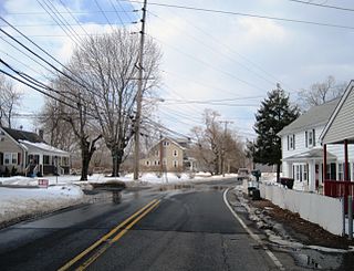
Route 156 is a 1.28-mile (2.06 km) long state highway in New Jersey, United States. It is a short connector in Yardville, a census-designated place which is part of Hamilton Township, Mercer County. It is an old two-lane alignment of U.S. Route 130 that was bypassed by a new multi-lane highway a short distance to the east in the 1950s, and designated just before the 1953 renumbering of state highways. The route intersects Route 130 at both termini; it carries local traffic to and from US 130 southbound through Yardville. The route has remained mainly intact since 1953.
U.S. Route 130 is a U.S. Highway that is a spur route of US 30, located completely within the state of New Jersey. It is signed with north and south cardinal directions, following a general northeast–southwest diagonal path, with "north" corresponding to the general eastward direction and vice versa. The route runs 83.46 mi (134.32 km) from Interstate 295 (I-295) and US 40 at Deepwater in Pennsville Township, Salem County, where the road continues south as Route 49, north to US 1 in North Brunswick Township, Middlesex County, where Route 171 continues north into New Brunswick. The route briefly runs concurrent with US 30 near Camden, about one-third of the way to New Brunswick. The road runs within a close distance of I-295 south of Bordentown and a few miles from the New Jersey Turnpike for its entire length, serving as a major four- to six-lane divided local road for most of its length. US 130 passes through many towns including Penns Grove, Bridgeport, Westville, Camden, Pennsauken, Burlington, Bordentown, Hightstown, and North Brunswick.

Harmony is an unincorporated community located within Jackson Township, in Ocean County, New Jersey, United States.
Interstate 195 (I-195) is an auxiliary route of the Interstate Highway System located in the U.S. state of New Jersey. Its western end is at I-295 and Route 29 just south of Trenton, New Jersey, in Hamilton Township, Mercer County, while its eastern end is at the Garden State Parkway, Route 34 and Route 138 in Wall Township, Monmouth County. I-195 is 34.17 miles (54.99 km) in length. The route is mostly a four-lane highway that runs through wooded areas in Central Jersey. It has an interchange with the New Jersey Turnpike (I-95) in Robbinsville Township and serves as a main access road to the Six Flags Great Adventure amusement park and the Jersey Shore. I-195 is occasionally referred to as the Central Jersey Expressway. On April 6, 1988, President Ronald Reagan signed H.R. 4263 naming Interstate 195 in New Jersey the James J. Howard Interstate Highway, in honor of the late James J. Howard.
County Route 571 is a county highway in the U.S. state of New Jersey. The highway extends 43.96 miles (70.75 km) from Route 37 in Toms River Township to Route 27 in Princeton. Though it is designated a north–south county route by the New Jersey Department of Transportation (NJDOT), it is signed both as north–south and east–west inconsistently.
County Route 539 is a county highway in the U.S. state of New Jersey. The highway extends 54.32 miles (87.42 km) from Main Street in Tuckerton to CR 535 in Cranbury Township. Much of the two-lane route passes through isolated areas of the Pine Barrens and the eastern end of the Fort Dix entity of Joint Base McGuire–Dix–Lakehurst. In these stretches, the route has a speed limit of 55 miles per hour (89 km/h), one of the few two-lane roads in the state to carry a 55 mph limit. CR 539 passes through three boroughs: Tuckerton, Allentown, and Hightstown. Other than those boroughs, the route travels mainly through rural townships.
County Route 535 is a county highway in the U.S. state of New Jersey. The highway extends 32.31 miles (52.00 km) from Logan Avenue, at the boundary between Trenton and Hamilton Township in Mercer County to an interchange with U.S. Route 9 (US 9) and Route 35 in South Amboy, Middlesex County.
County Route 526 is a county highway in the U.S. state of New Jersey. The highway extends 35.56 miles (57.23 km) from Princeton–Hightstown Road in West Windsor Township to Lanes Mill Road in Lakewood Township.
County Route 524 is a county highway in the U.S. state of New Jersey. The highway extends 39.90 miles (64.21 km) from the White Horse Circle in Hamilton Township to Route 71 in Spring Lake Heights.

Mercerville is an unincorporated community and census-designated place (CDP) located within Hamilton Township, in Mercer County, New Jersey, United States. As of the 2010 United States Census, the CDP's population was 13,230. Until after the 2000 Census, the area was part of the Mercerville-Hamilton Square CDP. For the 2010 Census it was split into two CDPs, Mercerville and Hamilton Square.

Hedding is an unincorporated community located within Mansfield Township, in Burlington County, New Jersey, United States. From 1793–1813, the area was known as Bryant's Tavern after William Byrant of Brian the proprietor. In 1817, the name was changed to Three Tuns as a sign before the hostelry depicted three casks or tuns. In 1847, a church was built which was named Hedding Methodist Episcopal Church in honor of Elijah Hedding, a Bishop of this denomination. Three Tuns remained as the name of the area until 1920 when it was changed to Hedding, named after the church. The community itself is made up of single-family houses clustered around the main intersection in the settlement, Old York Road and Kinkora Road / Columbus Hedding Road ; the remainder of the area consists of farmland. Interstate 295 runs southeast of the community but no interchanges provide direct access to it.
Etra is an unincorporated community located within East Windsor Township, in Mercer County, New Jersey, United States. It consists mostly of residential homes and farmland. East Windsor's largest park, Etra Lake Park, is located just east of the community.

Prospertown is an unincorporated community located within the New Jersey townships of Jackson and Plumsted in Ocean County and Upper Freehold in Monmouth County. The community is home to Prospertown Lake and is adjacent to Six Flags Great Adventure, both located on County Route 537. The center of the community is located at the intersection of CR 537, Hawkin Road, and Emleys Hill Road. Most of the area consists of pine forests but there are some homes along the roads in the area.
Millstone is an unincorporated community located within East Windsor Township in Mercer County, New Jersey, United States. Located in the northern portion of the township near Old Cranbury Road, U.S. Route 130, and New Jersey Route 133, it is a planned community constructed in the 1960s.

New Canton is an unincorporated community located along the border of Robbinsville Township in Mercer County and Upper Freehold Township in Monmouth County, New Jersey, United States. The area was once known as Cabbagetown and has been settled since the 18th century. The settlement is located at the intersection of Old York Road and New Canton-Stone Tavern Road just north of Interstate 195's interchange 8. The Upper Freehold side of the area contains farmland and new housing developments while the Robbinsville side features new commercial warehouse buildings including an Amazon.com Fulfillment Center opened in July 2014.

Sandy Ridge is an unincorporated community located within Delaware Township in Hunterdon County, New Jersey, United States. As its name implies, the community is located at the top of a small hill that is sandwiched between the Hunterdon Plateau and the Sourland Mountains. Sandy Ridge Road is the main road east and west through the community while County Route 605 is a minor arterial road that passes north and south through the area. CR 605 enters from the south on Sandy Ridge-Mt. Airy Road, jogs to the west on Sandy Ridge Road for 0.04 miles (64 m), and exits to the north on Cemetery Road towards CR 523. The area consists of mainly residences with some farmland and forestland. The Sandy Ridge Church is a Baptist church founded in 1818 with its current building constructed in 1866 and is located in the center of Sandy Ridge.

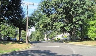
Burlington Heights is an unincorporated community located within Freehold Township in Monmouth County, New Jersey, United States. The community was created in the early 1960s and originally consisted of 112 homes of mixed styles designed by Peter Petillo and Associates of Freehold. It is located along Colts Neck Road on the east side of the township, near New Jersey Route 18 and the Colts Neck municipal line.

Lower Squankum is an unincorporated community located within Howell Township in Monmouth County, New Jersey, United States. The settlement is located along Lakewood-Farmingdale Road at its intersection with Herbertsville Road and Old Tavern Road in the eastern side of the township. It is also located near the boundary of Allaire State Park and is south of Interstate 195's exit 31. Nearby the community are the remains of the Lower Squankum Mill and the Lower Squankum Friends Burial Site, located within the median of CR 547 at the aforementioned interchange.

Headquarters is an unincorporated community located within Delaware Township in Hunterdon County, New Jersey, United States. The settlement is centered aon the crossing of Zentek Road over the Caponockons Creek, near the intersection of Zentek Road and Ringoes-Rosemont Road. The area is part of the Headquarters Historic District, a listing on the National Register of Historic Places. Headquarters was the site of a mill established in 1735, one of the first in Hunterdon County. The industry thrived until the early 20th century when the mill shut down. The district was first established as a historic area by Delaware Township in the 1980s to push back against a widening of CR 604. It is now on the national list of historic districts with a renewal of its boundaries occurring in 2016.


