
Trenton is the capital city of the U.S. state of New Jersey and the county seat of Mercer County. It was the capital of the United States from November 1 until December 24, 1784. Trenton and Princeton are the two principal cities of the Trenton–Princeton metropolitan statistical area, which encompasses those cities and all of Mercer County for statistical purposes and constitutes part of the New York combined statistical area by the U.S. Census Bureau. However, Trenton directly borders the Philadelphia metropolitan area to its west, and the city was part of the Philadelphia combined statistical area from 1990 until 2000.

Mercer County is a county located in the U.S. state of New Jersey. Its county seat is Trenton, also the state capital, prompting its nickname The Capital County. Mercer County alone constitutes the Trenton–Princeton metropolitan statistical area and is considered part of the New York combined statistical area by the U.S. Census Bureau, but also directly borders the Philadelphia metropolitan area and is included within the Federal Communications Commission's Philadelphia Designated Media Market Area. The county is part of the Central Jersey region of the state.

Ewing Township is a township in Mercer County, in the U.S. state of New Jersey. The township falls within the New York metropolitan area as defined by the U.S. Census Bureau. It borders the Philadelphia metropolitan area and is part of the Federal Communications Commission's Philadelphia Designated Market Area. As of the 2020 United States census, the township's population was 37,264, its highest decennial count ever and an increase of 1,474 (+4.1%) from the 35,790 recorded at the 2010 census, which in turn reflected an increase of 83 (+0.2%) from the 35,707 counted in the 2000 census.

Lawrence Township is a township in Mercer County, in the U.S. state of New Jersey. Located at the cross-roads between the Delaware Valley region to the southwest and the Raritan Valley region to the northeast, the township is an outer-ring suburb of New York City in the New York Metropolitan area, as defined by the United States Census Bureau, while also directly bordering the Philadelphia metropolitan area and is part of the Federal Communications Commission's Philadelphia Designated Market Area.

West Windsor is a township in Mercer County, in the U.S. state of New Jersey. Located at the cross-roads between the Delaware Valley region to the southwest and the Raritan Valley region to the northeast, the township is considered to be an outer-ring suburb of New York City in the New York metropolitan area, as defined by the United States Census Bureau. As of the 2020 United States census, the township's population was 29,518, its highest decennial count ever and an increase of 2,353 (+8.7%) from the 27,165 recorded at the 2010 census, which in turn reflected an increase of 5,258 (+24.0%) from the 21,907 counted in the 2000 census.
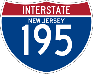
Interstate 195 (I-195) is an auxiliary route of the Interstate Highway System located in the US state of New Jersey. Its western end is at I-295 and Route 29 just south of Trenton in Hamilton Township, Mercer County, while its eastern end is at the Garden State Parkway, Route 138, and Route 34 in Wall Township, Monmouth County. I-195 is 34.17 miles (54.99 km) in length. The route is mostly a four-lane highway that mainly runs through agrarian and wooded areas in Central Jersey. It has an interchange with the New Jersey Turnpike (I-95) in Robbinsville Township and serves as a main access road to New Jersey's state capital of Trenton, the Horse Park of New Jersey, the Six Flags Great Adventure amusement park, and the Jersey Shore. I-195 is occasionally referred to as the Central Jersey Expressway. On April 6, 1988, President Ronald Reagan signed H.R. 4263 naming I-195 in New Jersey the James J. Howard Interstate Highway, in honor of the late James J. Howard.

North Trenton is a neighborhood located within the city of Trenton in Mercer County, in the U.S. state of New Jersey.

South Trenton is a neighborhood located within the city of Trenton in Mercer County, in the U.S. state of New Jersey. It is home to Italian Americans, Latin Americans, Irish Americans and their descendants. South Trenton borders Hamilton Township to the southeast and the Delaware River to the west. It had a brief existence as an independent municipality from 1840 to 1851.

West Trenton is an unincorporated community within Ewing Township in Mercer County, New Jersey, United States. It is a suburban area located adjacent to the northwestern portion of the city of Trenton, from which it derives its name. Located at the intersection of Bear Tavern Road/Grand Avenue and West Upper Ferry Road, it is one of the oldest settlements in Ewing Township.
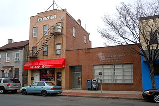
Chambersburg is a neighborhood located within the city of Trenton in Mercer County, in the U.S. state of New Jersey. It is considered part of South Trenton. Chambersburg was an independent municipality from 1872 to 1888.
Millham was a township that existed in Mercer County, New Jersey, United States, from 1882 to 1888.
Bonhamtown is a section of Edison Township in Middlesex County, New Jersey, United States.
Slackwood is an unincorporated community located within Lawrence Township in Mercer County, in the U.S. state of New Jersey. The area is named for the owners of the land that was subdivided into the neighborhood today, Joseph Slack and William Wood. The neighborhood was first developed in 1890 as the first suburban development in the reconfigured Lawrence Township. Its location between Princeton Pike and Brunswick Pike allowed for an easy walk to nearby Trenton factories. Today, most of the homes in Slackwood are still small bungalows with some businesses along with Princeton and Brunswick Pikes. The neighborhood is bounded by the two highways on the northwest and southeast, Slackwood Park and forest on the southwest, and Shabakunk Creek and Park on the northeast.
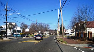
Eldridge Park is an unincorporated community located within Lawrence Township in Mercer County, in the U.S. state of New Jersey. The neighborhood is named for Stephen Eldridge, a farm owner in the township in the early 20th century. The neighborhood itself was established in 1906 as a settlement along the Trenton & Princeton Traction Company trolleyline and Lawrence Road for European immigrants to purchase small houses in the suburbs of Trenton. The growing population led to the construction of the Eldridge Park Elementary School and St. Ann's, the township's first Roman Catholic church. As it was in the past, the area is mostly made up of small houses with businesses clustered around US 206.

Duck Island is an unincorporated community located along the border of Hamilton Township and the city of Trenton in Mercer County, in the U.S. state of New Jersey. The community takes its name from Duck Island, which extends southeastward from the community. The city of Trenton provides public docks for fishing in Duck Island.

Top Road is a neighborhood located within the city of Trenton in Mercer County, in the U.S. state of New Jersey. Much of Top Road was once part of Lawrence Township and then was added to the now-defunct Millham Township before being annexed by Trenton in 1888.

Wilbur is a neighborhood located within the city of Trenton in Mercer County, in the U.S. state of New Jersey. It was an independent borough from 1891 to 1898.

The Island is a neighborhood in the city of Trenton in Mercer County, in the U.S. state of New Jersey. It is primarily a residential neighborhood consisting of detached, single-family homes and semi-attached (twin) residences built in the 1920s. The name is derived from it formerly being located on a man-made island bounded on the south and west by the Delaware River and on the north and east by the Trenton Water Power Canal. The canal was filled in to provide space for present-day Route 29 during the 1950s.
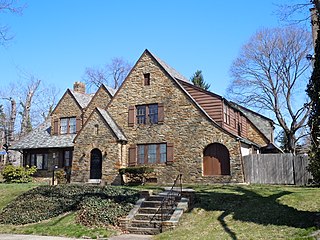
Berkeley Square, also known as Cadwalader Place, is a neighborhood located within the city of Trenton in Mercer County, in the U.S. state of New Jersey. It is primarily a residential neighborhood consisting of detached, single-family homes constructed in the late 19th century and early 20th century. As an extremely early example of suburbia, it was listed on the National Register of Historic Places in 1980.

Ewing/Carroll is a neighborhood located within the city of Trenton in Mercer County, in the U.S. state of New Jersey. It is considered to be an enclave within the larger Coalport/North Clinton neighborhood.


